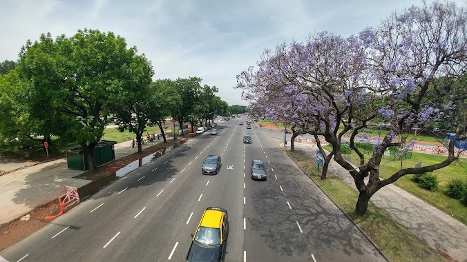
Park nearby Rubén Darío Park
Coronavirus disease (COVID-19) Situation
confirmed cases
10128845
deaths
130841
Argentina
Park nearby Rubén Darío Park
Rubén Darío Park
2302, Avenida Presidente Figueroa Alcorta, C1425, Comuna 2, Buenos Aires, AR Argentyna
contacts phone
:
+54 000000
website:
www.buenosaires.gob.ar
Latitude:
-34.5834072
, Longitude:
-58.3939051
larger map & directions
read more
nearest Park
Parque Rubén Darío
2800, C1425CKR, Avenida Presidente Figueroa Alcorta 2302
Park
read more
171 m
Plaza Francia
Buenos Aires
Park
read more
322 m
Plaza Int. Torcuato de Alvear
C1129AAQ, Emilio Pettorutti 2188-2200
Park
read more
324 m
Plaza Luis Federico Leloir
2599,C1425EIC, Agüero 2501
Park
read more
330 m
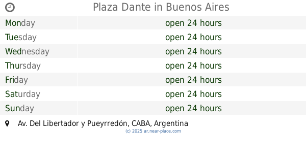
Plaza Dante
Av. Del Libertador y Pueyrredón
Park
read more
377 m
Plaza República Oriental del Uruguay
Recoleta
Park
read more
406 m
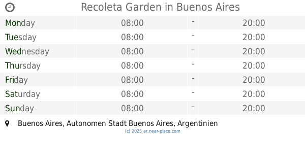
Recoleta Garden
Park
read more
408 m
Plazoleta Brig. Gral. Tomás de Iriarte
Park
read more
432 m
Plaza Julio de Caro
Avenida del Libertador 1201-1255, C1112ABC
Park
read more
446 m
Plaza Intendente Torcuato de Alvear
Avenida Pueyrredón
Park
read more
475 m
Solarium Plaza Francia
Park
read more
507 m
Square Ramón J. Cárcano
Park
read more
507 m
Plaza Ramón J. Cárcano
Park
read more
513 m
Reino de Tailandia
C1425EOA, Doctor Luis Agote 2201-2299
Park
read more
524 m
Plaza del Lector
Avenida General Las Heras 2505
Park
read more
525 m
C. González Pecotche
Galileo 2402-2420
Park
read more
525 m
Plazoleta Juan XXIII
C1113AAU, Junín 1849
Park
read more
526 m
Plaza San Martín de Tours
Avenida Alvear 2136
Park
read more
584 m
Plaza República de Chile
Av Libertador y Castilla, Palermo
Park
read more
649 m
Paseo de la Recoleta
Vicente López 2050
Park
read more
757 m
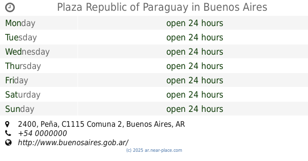
Plaza Republic of Paraguay
Peña 2400
Park
read more
804 m
Templo
Palermo
Park
read more
827 m
Plaza Bélgica
C1425CKX, Avenida Presidente Figueroa Alcorta 3102-3200
Park
read more
959 m
Alejandro Petión
Alejandro María de Aguado 2892-2900
Park
read more
1.269 km
Plaza Carlos Pellegrini
Avenida Alvear 1350
Park
read more
📑
all categories
Accounting
Administrative area level 1
Administrative area level 2
Airport
Amusement park
Aquarium
Art gallery
Atm
Bakery
Bank
Bar
Beauty salon
Bicycle store
Book store
Bowling alley
Bus station
Cafe
Campground
Car dealer
Car rental
Car repair
Car wash
Casino
Cemetery
Church
City hall
Clothing store
Colloquial area
Convenience store
Country
Courthouse
Dentist
Department store
Doctor
Electrician
Electronics store
Embassy
Establishment
Finance
Fire station
Florist
Food
Funeral home
Furniture store
Gas station
General contractor
Grocery or supermarket
Gym
Hair care
Hardware store
Health
Hindu Temple
Home goods store
Hospital
Insurance agency
Intersection
Jewelry store
Laundry
Lawyer
Library
Light rail station
Liquor store
Local government office
Locality
Locksmith
Lodging
Meal delivery
Meal takeaway
Mosque
Movie rental
Movie theater
Moving company
Museum
Natural feature
Neighborhood
Night club
Painter
Park
Parking
Pet store
Pharmacy
Physiotherapist
Place of worship
Plumber
Point of interest
Police
Political
Post office
Premise
Real estate agency
Restaurant
Roofing contractor
Route
Rv park, camping
School
Shoe store
Shopping mall
Spa
Stadium
Storage
Store
Subpremise
Subway station
Supermarket
Synagogue
Taxi stand
Train station
Transit station
Travel agency
University
Veterinary care
Zoo
sublocality level 1
sublocality level 3
↑