Parking nearby Estacionamiento Sila
Coronavirus disease (COVID-19) Situation
confirmed cases
10128845
deaths
130841
Argentina
Parking nearby Estacionamiento Sila
Estacionamiento Sila
349, Gascón, C1181ACE, Comuna 5, Buenos Aires, AR Argentina
contacts phone
:
+54 11 4981-3684
Latitude:
-34.6075809
, Longitude:
-58.4245469
larger map & directions
read more
nearest Parking
179 m
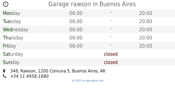
Garage rawson
Rawson 348
Parking
read more
180 m
Garage Figueroa Norte
Francisco Acuña de Figueroa 333
Parking
read more
264 m
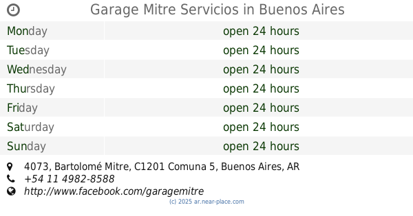
Garage Mitre Servicios
Bartolomé Mitre 4073
Parking
read more
301 m
TenetZ club de tenis
Estado de Palestina 555
Parking
read more
328 m
Garage
Estado de Palestina 556
Parking
read more
353 m
Garage Día Vélez 3861
Avenida Díaz Vélez 3839
Parking
read more
355 m
Estacionamiento Sarmiento
Sarmiento 4139
Parking
read more
368 m
Garage Glamaro S.R.L.
Argentina
Parking
read more
374 m
Garage Potosi 3836
Potosí 3846
Parking
read more
386 m
Garage Alison
Pringles 240
Parking
read more
419 m
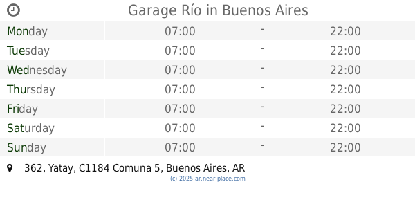
Garage Río
Yatay 362
Parking
read more
519 m
Iglesia Universal
Avenida Corrientes 4144
Parking
read more
744 m
Garage Bravo Mario 33
Mario Bravo 25
Parking
read more
747 m
Meller Norberto M
Yatay 864
Parking
read more
825 m
Garaje Bulnes
Humahuaca 3824
Parking
read more
858 m
Juan C Cattolico
Billinghurst 57
Parking
read more
886 m
Los Ruteros
Presidente Teniente General Juan Domingo Perón 3401
Parking
read more
914 m
Garage Boedo
Avenida Boedo 160
Parking
read more
961 m
Garage Gascon
Gascón 1005
Parking
read more
1.048 km
Butaca
C1174ACC, Virrey Liniers 191
Parking
read more
1.048 km
Parada ABASTO
Avenida Corrientes 3469
Parking
read more
1.068 km
Garage Bogota
Bogotá 172
Parking
read more
1.151 km
Garage Campi S.R.L.
Campichuelo 240
Parking
read more
1.17 km
Garage Vera 181
Vera 181
Parking
read more
1.243 km
Rao Domingo
Virrey Liniers 352
Parking
read more
📑
all categories
Accounting
Administrative area level 1
Administrative area level 2
Airport
Amusement park
Aquarium
Art gallery
Atm
Bakery
Bank
Bar
Beauty salon
Bicycle store
Book store
Bowling alley
Bus station
Cafe
Campground
Car dealer
Car rental
Car repair
Car wash
Casino
Cemetery
Church
City hall
Clothing store
Colloquial area
Convenience store
Country
Courthouse
Dentist
Department store
Doctor
Electrician
Electronics store
Embassy
Establishment
Finance
Fire station
Florist
Food
Funeral home
Furniture store
Gas station
General contractor
Grocery or supermarket
Gym
Hair care
Hardware store
Health
Hindu Temple
Home goods store
Hospital
Insurance agency
Intersection
Jewelry store
Laundry
Lawyer
Library
Light rail station
Liquor store
Local government office
Locality
Locksmith
Lodging
Meal delivery
Meal takeaway
Mosque
Movie rental
Movie theater
Moving company
Museum
Natural feature
Neighborhood
Night club
Painter
Park
Parking
Pet store
Pharmacy
Physiotherapist
Place of worship
Plumber
Point of interest
Police
Political
Post office
Premise
Real estate agency
Restaurant
Roofing contractor
Route
Rv park, camping
School
Shoe store
Shopping mall
Spa
Stadium
Storage
Store
Subpremise
Subway station
Supermarket
Synagogue
Taxi stand
Train station
Transit station
Travel agency
University
Veterinary care
Zoo
sublocality level 1
sublocality level 3
↑