Pharmacy nearby Farmacity
Coronavirus disease (COVID-19) Situation
confirmed cases
10128845
deaths
130841
Argentina
Pharmacy nearby Farmacity
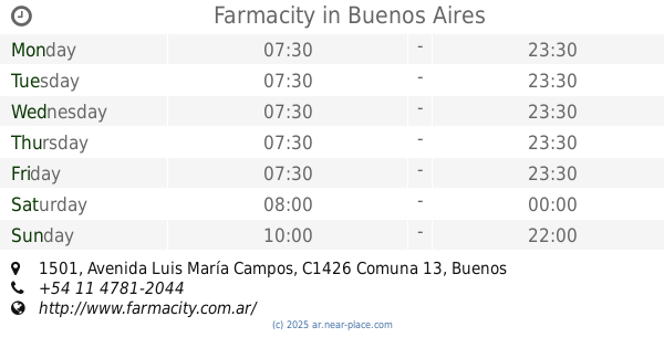
Farmacity
6068, Avenida del Libertador, C1428, Comuna 13, Buenos Aires, AR Argentina
contacts phone
:
+54 11 4780-2892
website:
www.farmacity.com.ar
Latitude:
-34.5561041
, Longitude:
-58.4484805
larger map & directions
read more
nearest Pharmacy
162 m
FARMACIA INTEGRAL
Juramento 1602
Pharmacy
read more
237 m
Farmacia Derby
Echeverría 1472
Pharmacy
read more
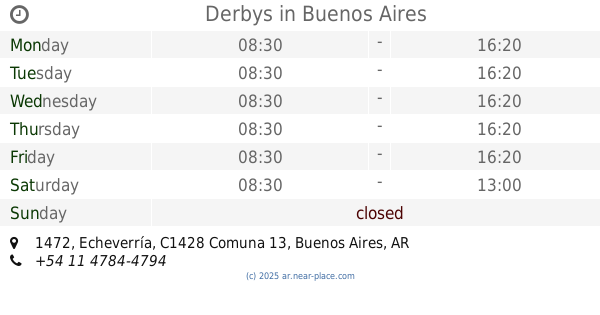
238 m
Derbys
Echeverría 1472
Pharmacy
read more
369 m
Alicia Scordo Pharmacy
Mariscal Antonio José de Sucre 1546
Pharmacy
read more
369 m
Alicia Scordo Farmacia
Mariscal Antonio José de Sucre 1546
Pharmacy
read more
527 m
Farmacity
Juramento 1941
Pharmacy
read more
604 m
Farmacia Salvatori
Juramento 2013
Pharmacy
read more
646 m
San Cristobal
Avenida Monroe 1993
Pharmacy
read more
647 m
SAN CRISTOBAL
Avenida Monroe 1901
Pharmacy
read more
665 m
San Diego
Arcos 2161
Pharmacy
read more
758 m
Farmacia Arcos 8 de Junio S.A.
Mariscal Antonio José de Sucre 2100
Pharmacy
read more
760 m
ARCOS
Mariscal Antonio José de Sucre 2092
Pharmacy
read more
858 m
Farmacity
Av. Luis María Campos 1501
Pharmacy
read more
858 m
Farmacity
Avenida Luis María Campos 1501
Pharmacy
read more
874 m
ATenas II
Arcos 1739
Pharmacy
read more
905 m
Botica del Arcon
La Pampa 2193
Pharmacy
read more
976 m
La Danesa
Avenida Cabildo 2171
Pharmacy
read more
977 m
Farmacity
Avenida Cabildo 2151
Pharmacy
read more
1.018 km
Farmacia de Las Torres
José Hernández 2225
Pharmacy
read more
1.033 km
Grimer Sa
Avenida Cabildo 2427
Pharmacy
read more
1.094 km
Farmacias Dr. AHORRO
Juramento 2477
Pharmacy
read more
1.098 km
La Danesa
C1428DNP, Juramento 2484
Pharmacy
read more
1.105 km
Farmacity
Avenida Cabildo 1840
Pharmacy
read more
1.212 km
El Cóndor
Avenida Federico Lacroze 1701
Pharmacy
read more
1.254 km
Farmacia 1810
Avenida Federico Lacroze 1810
Pharmacy
read more
📑
all categories
Accounting
Administrative area level 1
Administrative area level 2
Airport
Amusement park
Aquarium
Art gallery
Atm
Bakery
Bank
Bar
Beauty salon
Bicycle store
Book store
Bowling alley
Bus station
Cafe
Campground
Car dealer
Car rental
Car repair
Car wash
Casino
Cemetery
Church
City hall
Clothing store
Colloquial area
Convenience store
Country
Courthouse
Dentist
Department store
Doctor
Electrician
Electronics store
Embassy
Establishment
Finance
Fire station
Florist
Food
Funeral home
Furniture store
Gas station
General contractor
Grocery or supermarket
Gym
Hair care
Hardware store
Health
Hindu Temple
Home goods store
Hospital
Insurance agency
Intersection
Jewelry store
Laundry
Lawyer
Library
Light rail station
Liquor store
Local government office
Locality
Locksmith
Lodging
Meal delivery
Meal takeaway
Mosque
Movie rental
Movie theater
Moving company
Museum
Natural feature
Neighborhood
Night club
Painter
Park
Parking
Pet store
Pharmacy
Physiotherapist
Place of worship
Plumber
Point of interest
Police
Political
Post office
Premise
Real estate agency
Restaurant
Roofing contractor
Route
Rv park, camping
School
Shoe store
Shopping mall
Spa
Stadium
Storage
Store
Subpremise
Subway station
Supermarket
Synagogue
Taxi stand
Train station
Transit station
Travel agency
University
Veterinary care
Zoo
sublocality level 1
sublocality level 3
↑