Pharmacy nearby Farmacity
Coronavirus disease (COVID-19) Situation
confirmed cases
10128845
deaths
130841
Argentina
Pharmacy nearby Farmacity
Farmacity
1301, Avenida Independencia, C1100, Comuna 1, Buenos Aires, AR Argentina
contacts phone
:
+54 11 4381-7317
website:
www.farmacity.com
Latitude:
-34.6177632
, Longitude:
-58.384338
larger map & directions
read more
nearest Pharmacy
364 m
Farmacia Yerfino
Carlos Calvo 1500
Pharmacy
read more
652 m
Farmacia Y Optica Silvetti
Lima 330
Pharmacy
read more
685 m
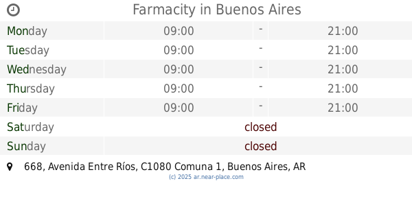
Farmacity
Ah, Avenida Entre Ríos 668
Pharmacy
read more
702 m
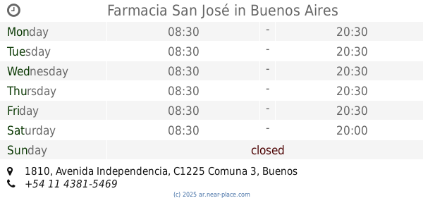
Farmacia San José
Avenida Independencia 1810
Pharmacy
read more
704 m
Farmacia Social
Moreno 1561
Pharmacy
read more
736 m
FARMACIA SOCIAL ONCE
C1073AAE, Lima 267
Pharmacy
read more
769 m
Farmacia Calper Sc
Pharmacy
read more
797 m
Diego F Salem
San José 1404
Pharmacy
read more
849 m
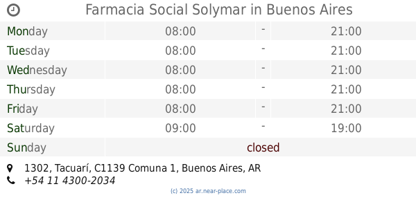
Farmacia Social Solymar
Tacuarí 1302
Pharmacy
read more
856 m
Farmacia Laion
Santiago del Estero 121
Pharmacy
read more
893 m
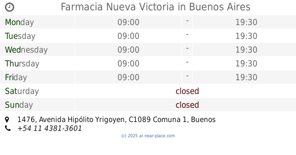
Farmacia Nueva Victoria
Avenida Hipólito Yrigoyen 1476
Pharmacy
read more
942 m
Farmacity
Avenida de Mayo 1300
Pharmacy
read more
946 m
Farmacia Nueva Avenida SRL
Avenida de Mayo 1180 C1085ABO
Pharmacy
read more
968 m
Farmacity
Avenida Hipólito Yrigoyen 992
Pharmacy
read more
968 m
Farmacity
Avenida Presidente Hipólito Yrigoyen 992
Pharmacy
read more
973 m
Yugo
H.Yrigoyen y B. Yrigoyen
Pharmacy
read more
976 m
Openfarma Orien
Avenida Entre Ríos 205
Pharmacy
read more
987 m
Pharmacy Av. De Mayo
Avenida de Mayo 1217
Pharmacy
read more
1.004 km
Veterinaria Neko
ACK, Humberto 1º 577
Pharmacy
read more
1.009 km
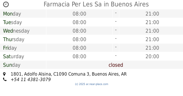
Farmacia Per Les Sa
Adolfo Alsina 1801
Pharmacy
read more
1.017 km
Farmacia Indiana
Chacabuco 1301
Pharmacy
read more
1.065 km
Farmacia del Sindicato de los Trabajadores Valijeros
Avenida Rivadavia 1581
Pharmacy
read more
1.086 km
Soy tu farmacia
Avenida de Mayo 892
Pharmacy
read more
1.201 km
Farmacity
C1022AAA, Avenida Callao 25
Pharmacy
read more
1.245 km
F.A.T.F.A
Constitución 2066
Pharmacy
read more
📑
all categories
Accounting
Administrative area level 1
Administrative area level 2
Airport
Amusement park
Aquarium
Art gallery
Atm
Bakery
Bank
Bar
Beauty salon
Bicycle store
Book store
Bowling alley
Bus station
Cafe
Campground
Car dealer
Car rental
Car repair
Car wash
Casino
Cemetery
Church
City hall
Clothing store
Colloquial area
Convenience store
Country
Courthouse
Dentist
Department store
Doctor
Electrician
Electronics store
Embassy
Establishment
Finance
Fire station
Florist
Food
Funeral home
Furniture store
Gas station
General contractor
Grocery or supermarket
Gym
Hair care
Hardware store
Health
Hindu Temple
Home goods store
Hospital
Insurance agency
Intersection
Jewelry store
Laundry
Lawyer
Library
Light rail station
Liquor store
Local government office
Locality
Locksmith
Lodging
Meal delivery
Meal takeaway
Mosque
Movie rental
Movie theater
Moving company
Museum
Natural feature
Neighborhood
Night club
Painter
Park
Parking
Pet store
Pharmacy
Physiotherapist
Place of worship
Plumber
Point of interest
Police
Political
Post office
Premise
Real estate agency
Restaurant
Roofing contractor
Route
Rv park, camping
School
Shoe store
Shopping mall
Spa
Stadium
Storage
Store
Subpremise
Subway station
Supermarket
Synagogue
Taxi stand
Train station
Transit station
Travel agency
University
Veterinary care
Zoo
sublocality level 1
sublocality level 3
↑