Pharmacy nearby M.Juncal
Coronavirus disease (COVID-19) Situation
confirmed cases
10128845
deaths
130841
Argentina
Pharmacy nearby M.Juncal
M.Juncal
2733, Juncal, C1425, Comuna 2, Buenos Aires, AR Argentina
contacts phone
:
+54 11 4821-5080
Latitude:
-34.5892995
, Longitude:
-58.40455
larger map & directions
read more
nearest Pharmacy
354 m
Soy Nueva Norte
Avenida Santa Fe 2936, Recoleta
Pharmacy
read more
354 m
Farmacia Nueva Norte Scs
Avenida Santa Fe 2936
Pharmacy
read more
363 m
La Nouvelle Pharmacie
Austria 2270
Pharmacy
read more
423 m
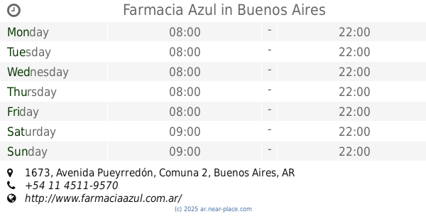
Farmacia Azul
Avenida Pueyrredón 1673
Pharmacy
read more
438 m
FARMACIA LA BOTICA DE BERUTI
Beruti 3300
Pharmacy
read more
447 m
Soy Franco Alemana
Antonio Beruti 2502, Recoleta
Pharmacy
read more
447 m
Soy Franco Alemana
Beruti 2502, Recoleta
Pharmacy
read more
448 m
Farmacia Vantage Franco Alemana
Beruti 2502
Pharmacy
read more
580 m
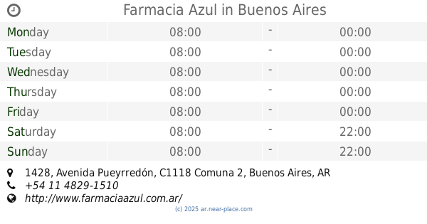
Farmacia Azul
Avenida Pueyrredón 1428
Pharmacy
read more
743 m
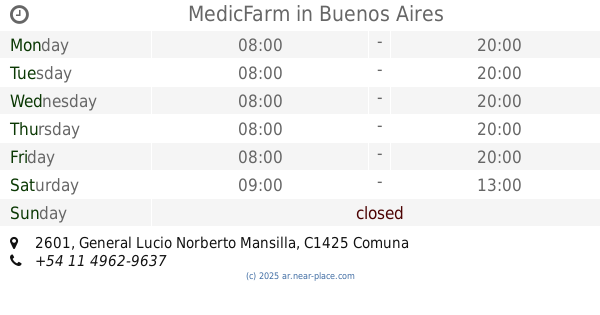
MedicFarm
General Lucio Norberto Mansilla 2601
Pharmacy
read more
750 m
Farmacia Scienza
Güemes 3500
Pharmacy
read more
831 m
Farmacia Politi - Polifarm SRL
Marcelo Torcuato de Alvear 2408
Pharmacy
read more
831 m
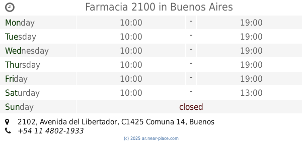
Farmacia 2100
Avenida del Libertador 2102
Pharmacy
read more
860 m
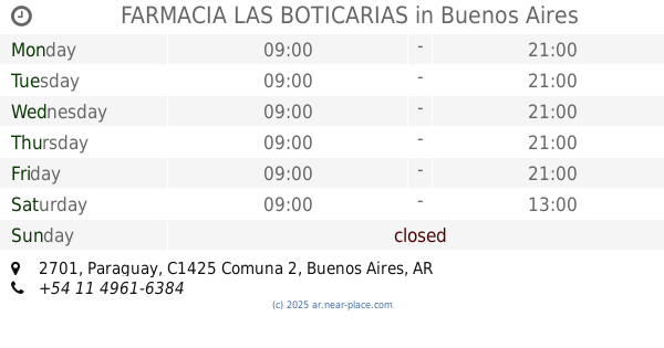
FARMACIA LAS BOTICARIAS
Paraguay 2701
Pharmacy
read more
918 m
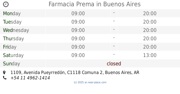
Farmacia Prema
Avenida Pueyrredón 1109
Pharmacy
read more
928 m
Farmacity
Avenida General Las Heras 2055
Pharmacy
read more
946 m
Farmacia D y L
Aráoz 2800
Pharmacy
read more
959 m
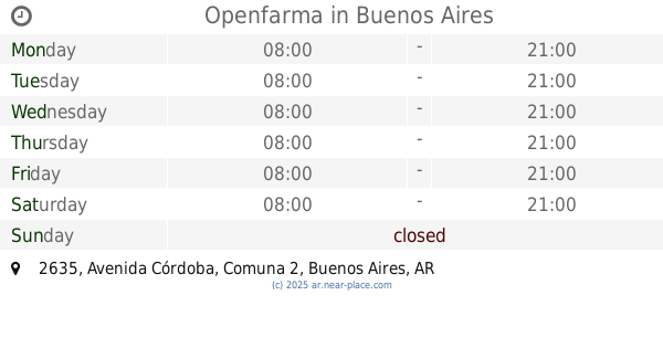
Openfarma
Avenida Córdoba 2635
Pharmacy
read more
965 m
Farmacia de Hoyos
Ayacucho 1241
Pharmacy
read more
978 m
Get The Look
Vicente López 2050
Pharmacy
read more
982 m
Farmacia Caledonia
Güemes 3732
Pharmacy
read more
1.01 km
farmacia health
C1121ABL, Paraguay 2322
Pharmacy
read more
1.018 km
Pharma Health
Paraguay 2332
Pharmacy
read more
1.111 km
Farmacity
Raúl Scalabrini Ortíz 3149
Pharmacy
read more
1.131 km
TKL
Marcelo Torcuato de Alvear 2045
Pharmacy
read more
📑
all categories
Accounting
Administrative area level 1
Administrative area level 2
Airport
Amusement park
Aquarium
Art gallery
Atm
Bakery
Bank
Bar
Beauty salon
Bicycle store
Book store
Bowling alley
Bus station
Cafe
Campground
Car dealer
Car rental
Car repair
Car wash
Casino
Cemetery
Church
City hall
Clothing store
Colloquial area
Convenience store
Country
Courthouse
Dentist
Department store
Doctor
Electrician
Electronics store
Embassy
Establishment
Finance
Fire station
Florist
Food
Funeral home
Furniture store
Gas station
General contractor
Grocery or supermarket
Gym
Hair care
Hardware store
Health
Hindu Temple
Home goods store
Hospital
Insurance agency
Intersection
Jewelry store
Laundry
Lawyer
Library
Light rail station
Liquor store
Local government office
Locality
Locksmith
Lodging
Meal delivery
Meal takeaway
Mosque
Movie rental
Movie theater
Moving company
Museum
Natural feature
Neighborhood
Night club
Painter
Park
Parking
Pet store
Pharmacy
Physiotherapist
Place of worship
Plumber
Point of interest
Police
Political
Post office
Premise
Real estate agency
Restaurant
Roofing contractor
Route
Rv park, camping
School
Shoe store
Shopping mall
Spa
Stadium
Storage
Store
Subpremise
Subway station
Supermarket
Synagogue
Taxi stand
Train station
Transit station
Travel agency
University
Veterinary care
Zoo
sublocality level 1
sublocality level 3
↑