Pharmacy nearby Promedic
Argentina
Pharmacy nearby Promedic
Promedic
1950-1958, Ángel Justiniano Carranza, Comuna 14, Buenos Aires, AR Argentinien
contacts phone
:
+54
Latitude:
-34.5805493
, Longitude:
-58.4360775
larger map & directions
read more
nearest Pharmacy
87 m
Maggi
Ángel Justiniano Carranza 2002
Pharmacy
read more
407 m
La Franco
Bonpland 1631
Pharmacy
read more
436 m
Farmacia Bonpland
Paraguay 5301
Pharmacy
read more
542 m
Farmacia Galicia
Bonpland 1507
Pharmacy
read more
549 m
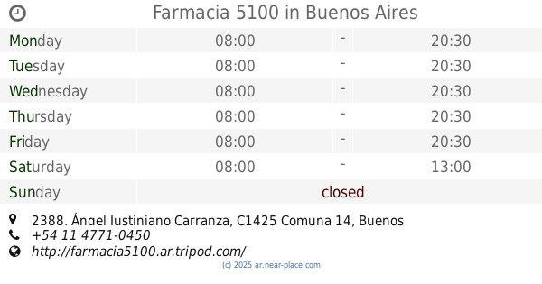
Farmacia 5100
Ángel Justiniano Carranza 2388
Pharmacy
read more
558 m
De los Santos Juan
Bonpland 1507
Pharmacy
read more
623 m
Charite
Paraguay 5002
Pharmacy
read more
705 m
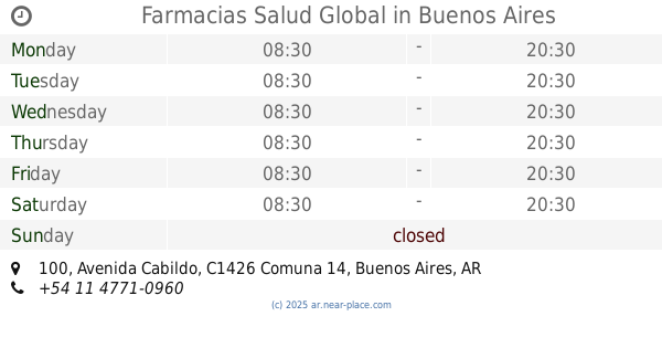
Farmacias Salud Global
Avenida Cabildo 100
Pharmacy
read more
747 m
Farmacia Nueva Aries
Avenida Santa Fe 4900, palermo
Pharmacy
read more
842 m
Farmacias ABC
Avenida Santa Fe 4800
Pharmacy
read more
842 m
Petville Petshop Palermo
Fray Justo Santa María de Oro 2193
Pharmacy
read more
845 m
Veterinaria SYBA
Te. Benjamín Matienzo 2504
Pharmacy
read more
861 m
Farmacia Granaderos
Avenida Luis María Campos 315
Pharmacy
read more
865 m
Gómez Quispe Mery L. y Valeriano Gómez E.
Avenida Luis María Campos 315
Pharmacy
read more
880 m
Estacion De Llavallol
Nicaragua 4942
Pharmacy
read more
937 m
La Franco
Paraguay 4695
Pharmacy
read more
972 m
Magda
Avenida Luis María Campos 500
Pharmacy
read more
1.044 km
SM Farma Express
Supermercado Vea, Avenida Córdoba 6150
Pharmacy
read more
1.062 km
Pharmacy Costa Rica
Costa Rica 4799
Pharmacy
read more
1.12 km
Portofino
Portal Palermo Shopping, Avenida Intendente Bullrich 345
Pharmacy
read more
1.136 km
Veterinaria Manoba, de Dra. Laura Mustillo
Nicaragua 4732
Pharmacy
read more
1.158 km
I am Your Pharmacy
Avenida Cerviño
Pharmacy
read more
1.171 km
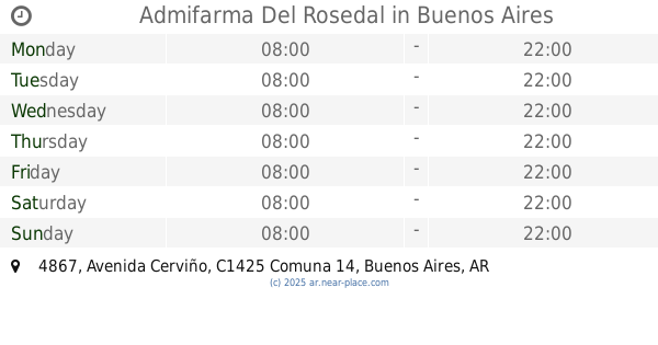
Admifarma Del Rosedal
Avenida Cerviño 4867
Pharmacy
read more
1.327 km
Farmacia Nueva Lacroze
Avenida Federico Lacroze 2599
Pharmacy
read more
1.327 km
Farmacia Nueva Lacroze
Av. Federico Lacroze 2599
Pharmacy
read more
📑
all categories
Accounting
Administrative area level 1
Administrative area level 2
Airport
Amusement park
Aquarium
Art gallery
Atm
Bakery
Bank
Bar
Beauty salon
Bicycle store
Book store
Bowling alley
Bus station
Cafe
Campground
Car dealer
Car rental
Car repair
Car wash
Casino
Cemetery
Church
City hall
Clothing store
Colloquial area
Convenience store
Country
Courthouse
Dentist
Department store
Doctor
Electrician
Electronics store
Embassy
Establishment
Finance
Fire station
Florist
Food
Funeral home
Furniture store
Gas station
General contractor
Grocery or supermarket
Gym
Hair care
Hardware store
Health
Hindu Temple
Home goods store
Hospital
Insurance agency
Intersection
Jewelry store
Laundry
Lawyer
Library
Light rail station
Liquor store
Local government office
Locality
Locksmith
Lodging
Meal delivery
Meal takeaway
Mosque
Movie rental
Movie theater
Moving company
Museum
Natural feature
Neighborhood
Night club
Painter
Park
Parking
Pet store
Pharmacy
Physiotherapist
Place of worship
Plumber
Point of interest
Police
Political
Post office
Premise
Real estate agency
Restaurant
Roofing contractor
Route
Rv park, camping
School
Shoe store
Shopping mall
Spa
Stadium
Storage
Store
Subpremise
Subway station
Supermarket
Synagogue
Taxi stand
Train station
Transit station
Travel agency
University
Veterinary care
Zoo
sublocality level 1
sublocality level 3
↑