Restaurant nearby Agatta
Argentina
Restaurant nearby Agatta
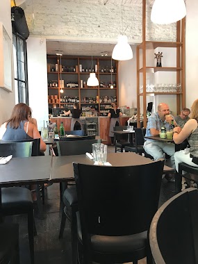
Agatta
3059, Avenida Elcano, C1426, Comuna 13, Buenos Aires, AR Argentina
contacts phone
:
+54 11 4552-1281
Latitude:
-34.571556
, Longitude:
-58.458763
larger map & directions
read more
nearest Restaurant
14 m
Betos Lomos
Avenida Elcano 3055
Restaurant
read more
30 m
Almacén de Pizzas
Avenida Elcano 3043
Restaurant
read more
74 m
Ding Sheng
Capitán General Ramón Freire 1539
Restaurant
read more
130 m
Restaurante Bambi
Capitán General Ramón Freire 1499
Restaurant
read more
325 m
Pizzeria Foggia Envios A Domicilio
Superí 1402
Restaurant
read more
406 m
Dorado
Capitán General Ramón Freire 1229
Restaurant
read more
426 m
La Gripella
Capitán General Ramón Freire 1201
Restaurant
read more
440 m
Pizza Chopping
Gral E Mart�nez 1425, Capital Federal, Capital Federal
Restaurant
read more
536 m
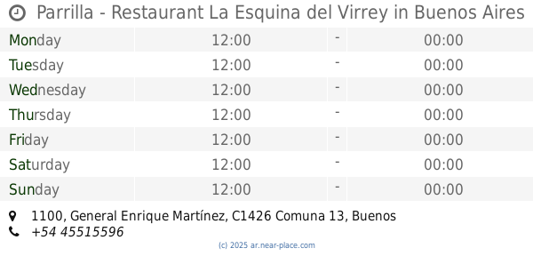
Parrilla - Restaurant La Esquina del Virrey
General Enrique Martínez 1100
Restaurant
read more
663 m
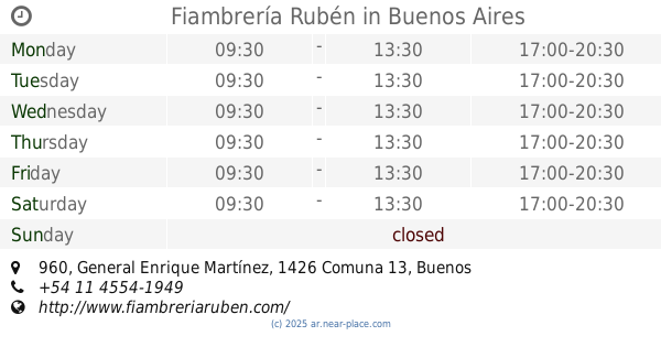
Fiambrería Rubén
General Enrique Martínez 960
Restaurant
read more
687 m
Gurú Deli
Mariscal Antonio José de Sucre 2676
Restaurant
read more
701 m
Comida China
Echeverría 2804
Restaurant
read more
814 m
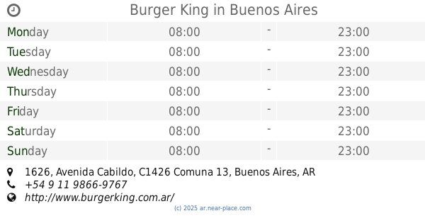
Burger King
Avenida Cabildo 1626
Restaurant
read more
824 m
Delicity
Mariscal Antonio José de Sucre 2500
Restaurant
read more
828 m
El Esquinazo
Amenábar 2000
Restaurant
read more
861 m
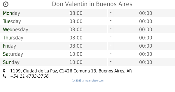
Don Valentin
Ciudad de La Paz 1199
Restaurant
read more
868 m
ESTOMBA BRASSERIE
Avenida de los Incas 3802
Restaurant
read more
938 m
Costumbres Argentinas
Virrey Avilés 3888
Restaurant
read more
984 m
CHINA TOWN EL WOK
Mendoza 2709
Restaurant
read more
1.007 km
Rotiseria la Abuela Carmen Delivery
Estomba 1244, Bahía Blanca
Restaurant
read more
1.01 km
Whoopies
C1426AAM, Avenida Cabildo 1287
Restaurant
read more
1.195 km
El Rey de la Milanesa
Holmberg 1415
Restaurant
read more
1.201 km
Baladi
Avenida Álvarez Thomas 630
Restaurant
read more
1.231 km
La Casa de Adann
O'Higgins 1731
Restaurant
read more
1.236 km
McDonald's
Avenida Álvarez Thomas 535-599
Restaurant
read more
📑
all categories
Accounting
Administrative area level 1
Administrative area level 2
Airport
Amusement park
Aquarium
Art gallery
Atm
Bakery
Bank
Bar
Beauty salon
Bicycle store
Book store
Bowling alley
Bus station
Cafe
Campground
Car dealer
Car rental
Car repair
Car wash
Casino
Cemetery
Church
City hall
Clothing store
Colloquial area
Convenience store
Country
Courthouse
Dentist
Department store
Doctor
Electrician
Electronics store
Embassy
Establishment
Finance
Fire station
Florist
Food
Funeral home
Furniture store
Gas station
General contractor
Grocery or supermarket
Gym
Hair care
Hardware store
Health
Hindu Temple
Home goods store
Hospital
Insurance agency
Intersection
Jewelry store
Laundry
Lawyer
Library
Light rail station
Liquor store
Local government office
Locality
Locksmith
Lodging
Meal delivery
Meal takeaway
Mosque
Movie rental
Movie theater
Moving company
Museum
Natural feature
Neighborhood
Night club
Painter
Park
Parking
Pet store
Pharmacy
Physiotherapist
Place of worship
Plumber
Point of interest
Police
Political
Post office
Premise
Real estate agency
Restaurant
Roofing contractor
Route
Rv park, camping
School
Shoe store
Shopping mall
Spa
Stadium
Storage
Store
Subpremise
Subway station
Supermarket
Synagogue
Taxi stand
Train station
Transit station
Travel agency
University
Veterinary care
Zoo
sublocality level 1
sublocality level 3
↑