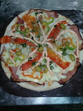
Restaurant nearby Che Pizza
Coronavirus disease (COVID-19) Situation
confirmed cases
10128845
deaths
130841
Argentina
Restaurant nearby Che Pizza
Che Pizza
977, Madero, C1408, Comuna 10, Buenos Aires, AR Argentina
contacts phone
:
+54
Latitude:
-34.6263581
, Longitude:
-58.5275596
larger map & directions
read more
nearest Restaurant
127 m
Avellino
Nogoyá 6099
Restaurant
read more
217 m
El Vikingo Pizzería
C1408BVW, Barragán 1195
Restaurant
read more
219 m
Maria C Garcia
Nogoyá 6050
Restaurant
read more
432 m
Amici
Simbrón 6065
Restaurant
read more
462 m
Parrilla El Abuelo
Madero 700
Restaurant
read more
462 m
Parrilla El Abuelo
700, Madero
Restaurant
read more
479 m
Fuegos Artificiales Eclipse
Avenida General Paz
Restaurant
read more
587 m
La Nona De Chiqui
Irigoyen 1801
Restaurant
read more
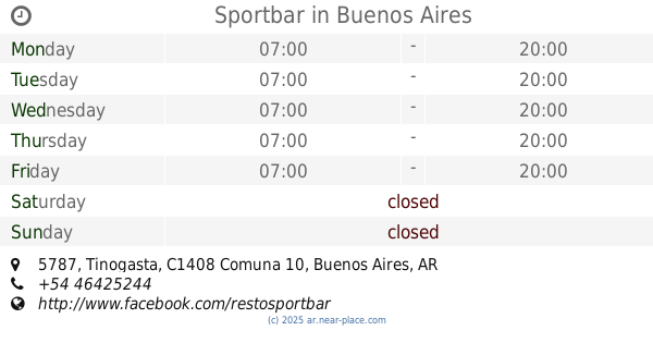
615 m
Sportbar
Tinogasta 5787
Restaurant
read more
636 m
OMA PIZZAS
Gallardo 599
Restaurant
read more
640 m
Tacos Friends SRL
República Árabe Siria 1120, José Ingenieros
Restaurant
read more
881 m
El Gran Cheff
Avenida Álvarez Jonte 6383, C1407FAB
Restaurant
read more
941 m
Comidas Y Bebidas 24hs
Ciudadela
Restaurant
read more
957 m
RESTO BAR Tivoli
Avenida Álvarez Jonte 6202
Restaurant
read more
959 m
Tuty Fruty
Av F Beir� 5782, Capital Federal, Capital Federal
Restaurant
read more
1.007 km
El Kapo Pizza Party
Avenida Francisco Beiró 5741
Restaurant
read more
1.007 km
La Gran Via
Avenida Juan Bautista Justo 9270
Restaurant
read more
1.047 km
manteles
Simbrón 5500-5402, C1408BHD
Restaurant
read more
1.071 km
Restaurante del Club Vélez Sarsfield
Avenida Álvarez Jonte C1408BXT, Buenos Aires
Restaurant
read more
1.165 km
La Quebrada
Restaurant
read more
1.172 km
Parrilla Py
Reconquista 600, Ciudadela
Restaurant
read more
1.174 km
Margarita
Avenida Lope de Vega 2453
Restaurant
read more
1.198 km
Pizzería Zapi
Avenida Lope de Vega 2207
Restaurant
read more
1.199 km
Pizza NOW Express
Avenida Lope de Vega 2203, C1417COF
Restaurant
read more
1.2 km
Pizza Lope De vega
Avenida Lope de Vega 2207
Restaurant
read more
📑
all categories
Accounting
Administrative area level 1
Administrative area level 2
Airport
Amusement park
Aquarium
Art gallery
Atm
Bakery
Bank
Bar
Beauty salon
Bicycle store
Book store
Bowling alley
Bus station
Cafe
Campground
Car dealer
Car rental
Car repair
Car wash
Casino
Cemetery
Church
City hall
Clothing store
Colloquial area
Convenience store
Country
Courthouse
Dentist
Department store
Doctor
Electrician
Electronics store
Embassy
Establishment
Finance
Fire station
Florist
Food
Funeral home
Furniture store
Gas station
General contractor
Grocery or supermarket
Gym
Hair care
Hardware store
Health
Hindu Temple
Home goods store
Hospital
Insurance agency
Intersection
Jewelry store
Laundry
Lawyer
Library
Light rail station
Liquor store
Local government office
Locality
Locksmith
Lodging
Meal delivery
Meal takeaway
Mosque
Movie rental
Movie theater
Moving company
Museum
Natural feature
Neighborhood
Night club
Painter
Park
Parking
Pet store
Pharmacy
Physiotherapist
Place of worship
Plumber
Point of interest
Police
Political
Post office
Premise
Real estate agency
Restaurant
Roofing contractor
Route
Rv park, camping
School
Shoe store
Shopping mall
Spa
Stadium
Storage
Store
Subpremise
Subway station
Supermarket
Synagogue
Taxi stand
Train station
Transit station
Travel agency
University
Veterinary care
Zoo
sublocality level 1
sublocality level 3
↑