Restaurant nearby Mwafi
Argentina
Restaurant nearby Mwafi
Mwafi
1725, Teodoro García, C1426, C1426DMC, Comuna 14, AR Argentina
contacts phone
:
+54 47760718
Latitude:
-34.5632492
, Longitude:
-58.4401484
larger map & directions
read more
nearest Restaurant
319 m
DIXTON Urban Food
Soldado de la Independencia 1073
Restaurant
read more
419 m
Chef León
Soldado de la Independencia 1002
Restaurant
read more
436 m
Naturally Fresh Fast Food
Migueletes 994
Restaurant
read more
458 m
Casita
Gorostiaga 1837, C1426CTG
Restaurant
read more
518 m
Hamburguesas
Olleros 2001, 2199
Restaurant
read more
681 m
La Candela Pizzería
C1426CXB, Jorge Newbery 1528
Restaurant
read more
746 m
BC Parrilla De La Esquina
sucre y, Miñones, Buenos Aires
Restaurant
read more
757 m
Kansas Grill & Bar
Av. Libertador 4625
Restaurant
read more
793 m
Mi Barrio Hamburguesería
Teniente Benjamín Matienzo 1680
Restaurant
read more
882 m
Subway
Avenida Cabildo 1129
Restaurant
read more
897 m
La Casa de Adann
O'Higgins 1731
Restaurant
read more
935 m
Whoopies
C1426AAM, Avenida Cabildo 1287
Restaurant
read more
937 m
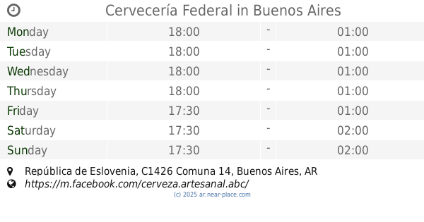
Cervecería Federal
C1426CZE 1831, CZE, República de Eslovenia
Restaurant
read more
963 m
Chinese Restorant
O'Higgins
Restaurant
read more
989 m
Below Pizza
Juramento 1424
Restaurant
read more
1.015 km
Xin Le Yuan Mei Shi
Av. Locale 10, C1428AME, Juramento 1700
Restaurant
read more
1.057 km
新乐园美食城
Juramento 1694 local 13
Restaurant
read more
1.077 km
Meet&Food GlamOut - Federico Cassino
Ciudad de La Paz 614, Buenos Aires
Restaurant
read more
1.083 km
Barrio Chino
Restaurant
read more
1.161 km
Taiwanway
Mendoza 1629
Restaurant
read more
1.175 km
Nobiru Izakaya
Mendoza 1627
Restaurant
read more
1.176 km
Restaurante Taiwanes Vegetariano
Mendoza 1631, C1428DJO
Restaurant
read more
1.204 km
El Cisne Blanco (sucursal)
C1428AQI, Montañeses 2231
Restaurant
read more
1.244 km
Mi Barrio Hamburguesería Belgrano
Olazábal 1422
Restaurant
read more
1.254 km
Distrito Beer Garden
Báez 315
Restaurant
read more
📑
all categories
Accounting
Administrative area level 1
Administrative area level 2
Airport
Amusement park
Aquarium
Art gallery
Atm
Bakery
Bank
Bar
Beauty salon
Bicycle store
Book store
Bowling alley
Bus station
Cafe
Campground
Car dealer
Car rental
Car repair
Car wash
Casino
Cemetery
Church
City hall
Clothing store
Colloquial area
Convenience store
Country
Courthouse
Dentist
Department store
Doctor
Electrician
Electronics store
Embassy
Establishment
Finance
Fire station
Florist
Food
Funeral home
Furniture store
Gas station
General contractor
Grocery or supermarket
Gym
Hair care
Hardware store
Health
Hindu Temple
Home goods store
Hospital
Insurance agency
Intersection
Jewelry store
Laundry
Lawyer
Library
Light rail station
Liquor store
Local government office
Locality
Locksmith
Lodging
Meal delivery
Meal takeaway
Mosque
Movie rental
Movie theater
Moving company
Museum
Natural feature
Neighborhood
Night club
Painter
Park
Parking
Pet store
Pharmacy
Physiotherapist
Place of worship
Plumber
Point of interest
Police
Political
Post office
Premise
Real estate agency
Restaurant
Roofing contractor
Route
Rv park, camping
School
Shoe store
Shopping mall
Spa
Stadium
Storage
Store
Subpremise
Subway station
Supermarket
Synagogue
Taxi stand
Train station
Transit station
Travel agency
University
Veterinary care
Zoo
sublocality level 1
sublocality level 3
↑