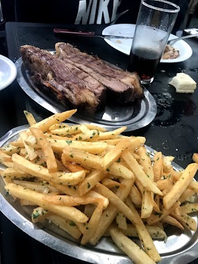
Restaurant nearby Pancho Báez
Coronavirus disease (COVID-19) Situation
confirmed cases
10128845
deaths
130841
Argentina
Restaurant nearby Pancho Báez
Pancho Báez
352, Báez, C1426, Comuna 14, Buenos Aires, AR Argentina
contacts phone
:
+54 11 2062-4256
Latitude:
-34.5718138
, Longitude:
-58.4317841
larger map & directions
read more
nearest Restaurant
41 m
Distrito Beer Garden
Báez 315
Restaurant
read more
119 m
Morelia
Báez 260
Restaurant
read more
175 m
Porto Pizza
2000, Avenida General Indalecio Chenaut 1982
Restaurant
read more
281 m
Parrilla Tito
C1425GAR, Avenida Dorrego 2720
Restaurant
read more
285 m
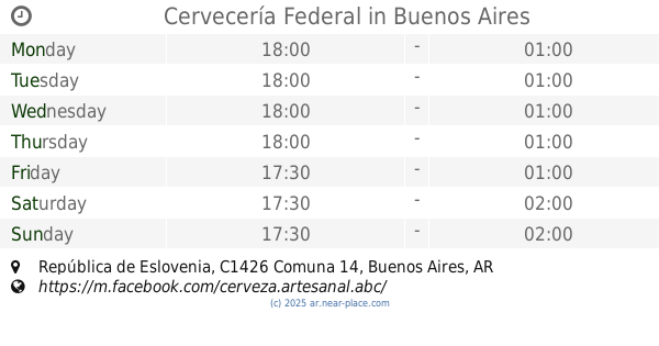
Cervecería Federal
C1426CZE 1831, CZE, República de Eslovenia
Restaurant
read more
451 m
obi bar
Avenida Santa Fe 5259
Restaurant
read more
456 m
Monkey Burgers
Avenida Luis María Campos 92
Restaurant
read more
458 m
Touch Restobar
Avenida Santa Fe 5361
Restaurant
read more
505 m
Tucson (Palermo)
Avenida del Libertador 4241
Restaurant
read more
530 m
La Casona Vegana
Viaducto Carranza 4701
Restaurant
read more
683 m
La Candela Pizzería
C1426CXB, Jorge Newbery 1528
Restaurant
read more
775 m
Casita
Gorostiaga 1837, C1426CTG
Restaurant
read more
788 m
Namida
2275, FWC, Bonpland
Restaurant
read more
826 m
Epa La Arepa Palermo
Soler 5837, Buenos Aires
Restaurant
read more
826 m
Bebidas Delivery
Soler 5835
Restaurant
read more
840 m
Epa La Arepa Palermo
Soler 5837
Restaurant
read more
851 m
La Cátedra Restaurante
Avenida Cerviño 4699
Restaurant
read more
900 m
Oui Oui
Nicaragua 6068
Restaurant
read more
949 m
Mc Donald's
C1425BHI, Avenida Santa Fe 4601
Restaurant
read more
966 m
La Pascana
Paraguay 5100
Restaurant
read more
978 m
Casona Vegana
y, Ángel Justiniano Carranza & Nicaragua
Restaurant
read more
989 m
The Argentine Experience
Fitz Roy 2110
Restaurant
read more
1.097 km
Hamburguesas
Olleros 2001, 2199
Restaurant
read more
1.098 km
Siamo nel Forno
Costa Rica 5886
Restaurant
read more
1.245 km
Blan & Co
C1414CLO, Avenida Dorrego 1940
Restaurant
read more
📑
all categories
Accounting
Administrative area level 1
Administrative area level 2
Airport
Amusement park
Aquarium
Art gallery
Atm
Bakery
Bank
Bar
Beauty salon
Bicycle store
Book store
Bowling alley
Bus station
Cafe
Campground
Car dealer
Car rental
Car repair
Car wash
Casino
Cemetery
Church
City hall
Clothing store
Colloquial area
Convenience store
Country
Courthouse
Dentist
Department store
Doctor
Electrician
Electronics store
Embassy
Establishment
Finance
Fire station
Florist
Food
Funeral home
Furniture store
Gas station
General contractor
Grocery or supermarket
Gym
Hair care
Hardware store
Health
Hindu Temple
Home goods store
Hospital
Insurance agency
Intersection
Jewelry store
Laundry
Lawyer
Library
Light rail station
Liquor store
Local government office
Locality
Locksmith
Lodging
Meal delivery
Meal takeaway
Mosque
Movie rental
Movie theater
Moving company
Museum
Natural feature
Neighborhood
Night club
Painter
Park
Parking
Pet store
Pharmacy
Physiotherapist
Place of worship
Plumber
Point of interest
Police
Political
Post office
Premise
Real estate agency
Restaurant
Roofing contractor
Route
Rv park, camping
School
Shoe store
Shopping mall
Spa
Stadium
Storage
Store
Subpremise
Subway station
Supermarket
Synagogue
Taxi stand
Train station
Transit station
Travel agency
University
Veterinary care
Zoo
sublocality level 1
sublocality level 3
↑