Restaurant nearby Tibó
Coronavirus disease (COVID-19) Situation
confirmed cases
10128845
deaths
130841
Argentina
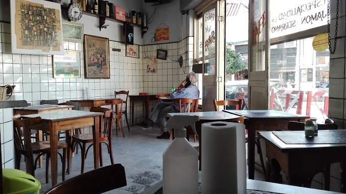
Restaurant nearby Tibó
Tibó
608, Atuel, C1437, Comuna 4, Buenos Aires, AR Argentina
contacts phone
:
+54 11 2085-3709
website:
somostibo.com
Latitude:
-34.6447209
, Longitude:
-58.4068863
larger map & directions
read more
nearest Restaurant
175 m
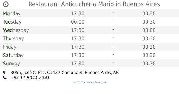
Restaurant Anticucheria Mario
José C. Paz 3055, Buenos Aires
Restaurant
read more
256 m
Taipan Retiro De MALTAS
C1437EVN, Monteagudo 630
Restaurant
read more
311 m
LA FAMILIA
Monteagudo 450
Restaurant
read more
436 m
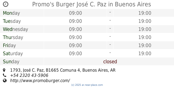
Promo's Burger José C. Paz
José C. Paz 1793
Restaurant
read more
442 m
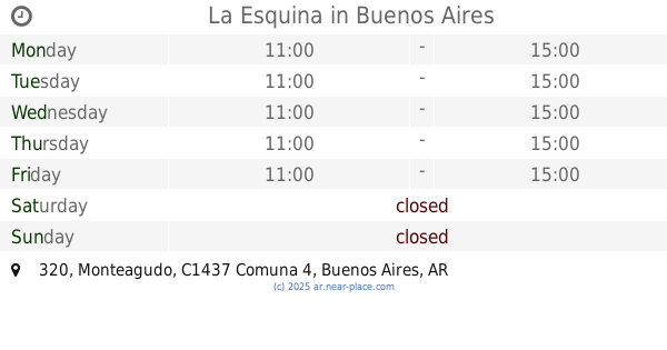
La Esquina
C1437EVH, Monteagudo 320
Restaurant
read more
643 m
Buyón Milanesas
Zavaleta 243, C1437EYE
Restaurant
read more
655 m
Pizza Forte
Avenida Almafuerte 503
Restaurant
read more
814 m
Las Tres Violetas
Uspallata 2801
Restaurant
read more
835 m
Heladerías Arte Gelatto
Avenida Caseros 3087
Restaurant
read more
836 m
PIZZERIA PICHIN
Avenida Almafuerte 9
Restaurant
read more
837 m
Jenecheru
Avenida Sáenz 456
Restaurant
read more
846 m
Restaurant Peña Criolla
Avenida Sáenz 496
Restaurant
read more
850 m
Rosas'delivery
Avenida Sáenz 481, C1437DNR
Restaurant
read more
853 m
Pizzeria Fenix
Avenida Sáenz 449
Restaurant
read more
926 m
Churdi!
Rondeau 3098
Restaurant
read more
933 m
Pizzeria Pizza Bay Restaurante
Avenida Sáenz 702
Restaurant
read more
953 m
Parrilla Jc
Alberto Einstein esq, Gutiérrez
Restaurant
read more
991 m
La pulpería del cotorro
C1437FEE, Luna 115
Restaurant
read more
1.012 km
El Ceibo
Ventura de la Vega 3520
Restaurant
read more
1.098 km
Pizzería 'Speed''
Avenida Sáenz 928
Restaurant
read more
1.105 km
Parrilla Los Nenes
Av. Colonia & Uspallata
Restaurant
read more
1.113 km
Raul H Diaz
Avenida Sáenz 928
Restaurant
read more
1.124 km
La caperuza RH
Parque Patricios
Restaurant
read more
1.165 km
La Rumba
Avenida Sáenz 963
Restaurant
read more
1.309 km
BRASAS BOEDO
Metán 3771
Restaurant
read more
📑
all categories
Accounting
Administrative area level 1
Administrative area level 2
Airport
Amusement park
Aquarium
Art gallery
Atm
Bakery
Bank
Bar
Beauty salon
Bicycle store
Book store
Bowling alley
Bus station
Cafe
Campground
Car dealer
Car rental
Car repair
Car wash
Casino
Cemetery
Church
City hall
Clothing store
Colloquial area
Convenience store
Country
Courthouse
Dentist
Department store
Doctor
Electrician
Electronics store
Embassy
Establishment
Finance
Fire station
Florist
Food
Funeral home
Furniture store
Gas station
General contractor
Grocery or supermarket
Gym
Hair care
Hardware store
Health
Hindu Temple
Home goods store
Hospital
Insurance agency
Intersection
Jewelry store
Laundry
Lawyer
Library
Light rail station
Liquor store
Local government office
Locality
Locksmith
Lodging
Meal delivery
Meal takeaway
Mosque
Movie rental
Movie theater
Moving company
Museum
Natural feature
Neighborhood
Night club
Painter
Park
Parking
Pet store
Pharmacy
Physiotherapist
Place of worship
Plumber
Point of interest
Police
Political
Post office
Premise
Real estate agency
Restaurant
Roofing contractor
Route
Rv park, camping
School
Shoe store
Shopping mall
Spa
Stadium
Storage
Store
Subpremise
Subway station
Supermarket
Synagogue
Taxi stand
Train station
Transit station
Travel agency
University
Veterinary care
Zoo
sublocality level 1
sublocality level 3
↑