School nearby BSPA 7169
Argentina
School nearby BSPA 7169
BSPA 7169
Salta, Argentina
contacts phone
:
+54
website:
bspalibertad.com.ar
Latitude:
-24.838939
, Longitude:
-65.3988711
larger map & directions
read more
nearest School
66 m
Escuela 4774 Juan José Valle
Calle S/nomb s/n, Salta
School
read more
269 m
CPI Solidaridad
A lote, Mendoza 402, Salta
School
read more
338 m
Colegio Fe Y Alegria Solidaridad
Salta
School
read more
356 m
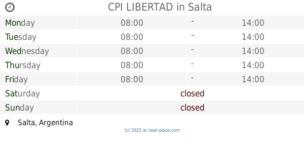
CPI LIBERTAD
Salta
School
read more
684 m
Fe y Alegria 8171 Nivel Inicial
Salta
School
read more
691 m
Escuela Fe Y Alegria Solidaridad, Nivel Primario
Salta
School
read more
723 m
Sector Operativa 8 A
Lucio Mansilla & Olivera, Salta
School
read more
723 m
colegio Siglo XXI
Salta
School
read more
748 m
Escuela N°4775 Elsa Salfity
esquina, Díaz Villalba & Martín Fierro, Salta
School
read more
748 m
Escuela N°4775 Elsa Salfity
esquina, Díaz Villalba, Salta
School
read more
767 m
Esc 4843 Bicentenario de la Batalla de Salta
Salta
School
read more
824 m
Tecnica 8
Salta
School
read more
840 m
Escuela N ° 4811 Crucero Ara Gral Belgrano 2 De Mayo
Salta
School
read more
872 m
Escuela 2 De Mayo Ara Gral Belgrano
Avenida Ingeniero, Salta
School
read more
944 m
School No. 4048 Salta Province
Salta
School
read more
965 m
JARDIN QUERUBINES
A. 276, Angela Cresseri de Correa, Salta
School
read more
995 m
Casa Educativa Terapéutica De San Benito
Salta
School
read more
1.026 km
Escuela Maria Elvira Reyes De Campos
Ruta Provincial 26, Salta
School
read more
1.059 km
Escuela La Candelaria
Ruta Provincial 26, Salta
School
read more
1.156 km
EET N° 3118
Avenida Discepolo, Salta
School
read more
1.312 km
Escuela N�4048 Pcia de Salta
Chazarreta, Salta
School
read more
1.321 km
Escuela Independencia Nacional
Esteban Echeverria, Salta
School
read more
1.363 km
CPI Eva Peron
Felipe Varela, Salta
School
read more
1.457 km
Instituto Dr. Facundo De Zuviria
Vicente López 38, Salta
School
read more
1.996 km
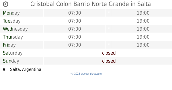
Cristobal Colon Barrio Norte Grande
Salta
School
read more
📑
all categories
Accounting
Administrative area level 1
Administrative area level 2
Airport
Amusement park
Aquarium
Art gallery
Atm
Bakery
Bank
Bar
Beauty salon
Bicycle store
Book store
Bowling alley
Bus station
Cafe
Campground
Car dealer
Car rental
Car repair
Car wash
Casino
Cemetery
Church
City hall
Clothing store
Colloquial area
Convenience store
Country
Courthouse
Dentist
Department store
Doctor
Electrician
Electronics store
Embassy
Establishment
Finance
Fire station
Florist
Food
Funeral home
Furniture store
Gas station
General contractor
Grocery or supermarket
Gym
Hair care
Hardware store
Health
Hindu Temple
Home goods store
Hospital
Insurance agency
Intersection
Jewelry store
Laundry
Lawyer
Library
Light rail station
Liquor store
Local government office
Locality
Locksmith
Lodging
Meal delivery
Meal takeaway
Mosque
Movie rental
Movie theater
Moving company
Museum
Natural feature
Neighborhood
Night club
Painter
Park
Parking
Pet store
Pharmacy
Physiotherapist
Place of worship
Plumber
Point of interest
Police
Political
Post office
Premise
Real estate agency
Restaurant
Roofing contractor
Route
Rv park, camping
School
Shoe store
Shopping mall
Spa
Stadium
Storage
Store
Subpremise
Subway station
Supermarket
Synagogue
Taxi stand
Train station
Transit station
Travel agency
University
Veterinary care
Zoo
sublocality level 1
sublocality level 3
↑