School nearby Colegio
Argentina
School nearby Colegio
Colegio
3246, Ricardo Gutiérrez, C1417, Comuna 11, Buenos Aires, AR Argentina
contacts phone
:
+54
Latitude:
-34.6018306
, Longitude:
-58.4959896
larger map & directions
read more
nearest School
167 m
Colegio San José
Pedro Lozano 3151
School
read more
191 m
Wall Street English Villa Del Parque
Melincué 3215
School
read more
284 m
Colegio Juan Millan
C1417CRE, Helguera 3205
School
read more
286 m
IEA
C1417EUF, Simbrón 3160
School
read more
315 m
Escuela Infantil MORUMBI
Simbrón 3106
School
read more
333 m
Escuela De Electronica Aplicada
2838 C1417AHP CABA AR C1417 AHP, Teodoro Vilardebó
School
read more
417 m
Taller Spencer Y Prego
School
read more
447 m
Antonio Dellepiano
Baigorria 3169, Buenos Aires
School
read more
503 m
escuela 10 de 17
C1417CQJ, Helguera 2435
School
read more
517 m
Shamrock Junior College
Baigorria 3054
School
read more
529 m
Instituto GLAUX - Nivel Secundario
Avenida Nazca 3330
School
read more
534 m
Sr. Pablo
C1417ALU, Emilio Lamarca 3117
School
read more
624 m
ESCUELA No. 3 PFA
Argerich 2849
School
read more
637 m
Platerillo
Terrada 3080
School
read more
639 m
Unisono danzas
Avenida Francisco Beiró 3531
School
read more
647 m
Salon VR Rom
Marcos Sastre 3563
School
read more
749 m
INSTITUTO ST. MARY'S
Condarco 3142
School
read more
778 m
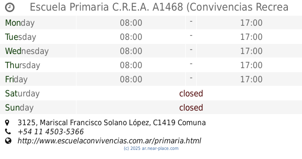
Escuela Primaria C.R.E.A. A1468 (Convivencias Recrea Educación Argentina)
Mariscal Francisco Solano López 3125
School
read more
788 m
Jardín Maternal Ruiditos
3501, GFY, Santo Tomé
School
read more
863 m
Pequeños Chefs
Santo Tomé 2943
School
read more
999 m
Hillel School
Helguera 2333
School
read more
1.016 km
Goblins Corner
Bahía Blanca 2658
School
read more
1.027 km
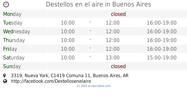
Destellos en el aire
Nueva York 3319
School
read more
1.116 km
Instituto Cardenal Copello
C1419HDF, Nueva York 3571
School
read more
1.189 km
Escuela 2 Distrito 16 República de Panamá
Avenida San Martín 6387
School
read more
📑
all categories
Accounting
Administrative area level 1
Administrative area level 2
Airport
Amusement park
Aquarium
Art gallery
Atm
Bakery
Bank
Bar
Beauty salon
Bicycle store
Book store
Bowling alley
Bus station
Cafe
Campground
Car dealer
Car rental
Car repair
Car wash
Casino
Cemetery
Church
City hall
Clothing store
Colloquial area
Convenience store
Country
Courthouse
Dentist
Department store
Doctor
Electrician
Electronics store
Embassy
Establishment
Finance
Fire station
Florist
Food
Funeral home
Furniture store
Gas station
General contractor
Grocery or supermarket
Gym
Hair care
Hardware store
Health
Hindu Temple
Home goods store
Hospital
Insurance agency
Intersection
Jewelry store
Laundry
Lawyer
Library
Light rail station
Liquor store
Local government office
Locality
Locksmith
Lodging
Meal delivery
Meal takeaway
Mosque
Movie rental
Movie theater
Moving company
Museum
Natural feature
Neighborhood
Night club
Painter
Park
Parking
Pet store
Pharmacy
Physiotherapist
Place of worship
Plumber
Point of interest
Police
Political
Post office
Premise
Real estate agency
Restaurant
Roofing contractor
Route
Rv park, camping
School
Shoe store
Shopping mall
Spa
Stadium
Storage
Store
Subpremise
Subway station
Supermarket
Synagogue
Taxi stand
Train station
Transit station
Travel agency
University
Veterinary care
Zoo
sublocality level 1
sublocality level 3
↑