School nearby Cuenca XV Sum
Argentina
School nearby Cuenca XV Sum
Cuenca XV Sum
Neuquén, Argentina
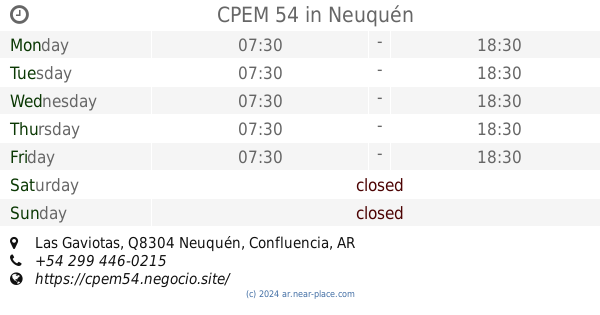
contacts phone
:
+54
Latitude:
-38.9276743
, Longitude:
-68.1287031
larger map & directions
read more
nearest School
236 m
Escuela Primaria N° 347
Caballería Fría y Miguel Cabrera. capital, Neuquén
School
read more
292 m
Jardin Integral N 66 Cuenca XV
Q8300JFH, Casimiro Gómez 2900, Neuquén
School
read more
361 m
CPEM 69
Neuquén
School
read more
446 m
Escuela 348
Neuquén
School
read more
703 m
Jardín de Infantes Nº42
Cayastá 2075, Q8300MNW
School
read more
942 m
E.P.E.T. N° 17
1998, Buffolo José, Neuquén
School
read more
1.008 km
KENT Institutos de Inglés
Raihue 4799, Neuquén
School
read more
1.112 km
Jardín Z1
Neuquén
School
read more
1.151 km
Escuela 362
Neuquén
School
read more
1.189 km
Jardín de Infantes N ° 32
Río Gallegos 1728-1670, Q8302DAG
School
read more
1.197 km
Guardería
Calle Lago Viedma, Neuquén
School
read more
1.221 km
Jardin de Infantes Nº36
Rosario &, Avenida del Trabajador, Neuquén
School
read more
1.221 km
jardin 36
Rosario &, Avenida del Trabajador, Neuquén
School
read more
1.231 km
Escuela 336
Ángel Pérez Novella y, Cayastá
School
read more
1.275 km
Escuela Primaria 295
Q8304JCX, Las Gaviotas 1678, Neuquén
School
read more
1.42 km
Escuela Nº 200
Coronel Jorge Rodhe Q8302EGG, Neuquén
School
read more
1.7 km
Escuela Nº199
1249,Q8304IZE, Las Gaviotas 1199, Neuquén
School
read more
1.864 km
Escuela Primaria 193
Q8304IZB, Las Gaviotas 1070, Neuquén
School
read more
1.886 km
CPEM 54
1099, Q8304IZA 999, IZA, Las Gaviotas, Neuquén
School
read more
1.899 km
UAF Heu Quiñe
Calle el Colibrí Q8300, Neuquén
School
read more
1.94 km
Las Gaviotas Y Juan José Castellii
Q8300HWJ, Juan José Castelli 4399-4499, Neuquén
School
read more
2.305 km
Escuela 356
cuenca 16, Neuquén
School
read more
2.658 km
Playon Beraka
Neuquen
School
read more
2.888 km
Fundacion Vida Cristiana
Coronel Godoy E. 250, Neuquén
School
read more
3.304 km
Escuela 343
Salcedo Maximo Luis 3435, Neuquén
School
read more
📑
all categories
Accounting
Administrative area level 1
Administrative area level 2
Airport
Amusement park
Aquarium
Art gallery
Atm
Bakery
Bank
Bar
Beauty salon
Bicycle store
Book store
Bowling alley
Bus station
Cafe
Campground
Car dealer
Car rental
Car repair
Car wash
Casino
Cemetery
Church
City hall
Clothing store
Colloquial area
Convenience store
Country
Courthouse
Dentist
Department store
Doctor
Electrician
Electronics store
Embassy
Establishment
Finance
Fire station
Florist
Food
Funeral home
Furniture store
Gas station
General contractor
Grocery or supermarket
Gym
Hair care
Hardware store
Health
Hindu Temple
Home goods store
Hospital
Insurance agency
Intersection
Jewelry store
Laundry
Lawyer
Library
Light rail station
Liquor store
Local government office
Locality
Locksmith
Lodging
Meal delivery
Meal takeaway
Mosque
Movie rental
Movie theater
Moving company
Museum
Natural feature
Neighborhood
Night club
Painter
Park
Parking
Pet store
Pharmacy
Physiotherapist
Place of worship
Plumber
Point of interest
Police
Political
Post office
Premise
Real estate agency
Restaurant
Roofing contractor
Route
Rv park, camping
School
Shoe store
Shopping mall
Spa
Stadium
Storage
Store
Subpremise
Subway station
Supermarket
Synagogue
Taxi stand
Train station
Transit station
Travel agency
University
Veterinary care
Zoo
sublocality level 1
sublocality level 3
↑