School nearby Escuela de suboficiales
Coronavirus disease (COVID-19) Situation
confirmed cases
10128845
deaths
130841
Argentina
School nearby Escuela de suboficiales
Escuela de suboficiales
Punta Arenas 1201 Argentina
contacts phone
:
+54
Latitude:
-34.589962
, Longitude:
-58.469462
read more
nearest School
104 m
Jardín Maternal San Agustín
Coronel Estomba 75, Sarandí
School
read more
160 m
Escuela 20
Campo, Buenos Aires
School
read more
278 m
Notaries Association of the City of Buenos Aires
Avenida Chorroarín 751
School
read more
351 m
Escuela Infantil Caballito de Mar
Tronador 412
School
read more
515 m
Cens 61
Balboa 210
School
read more
521 m
CENS 21
210, Balboa
School
read more
603 m
Escuela De Yani
599, C1427CJK, 14 de Julio 501
School
read more
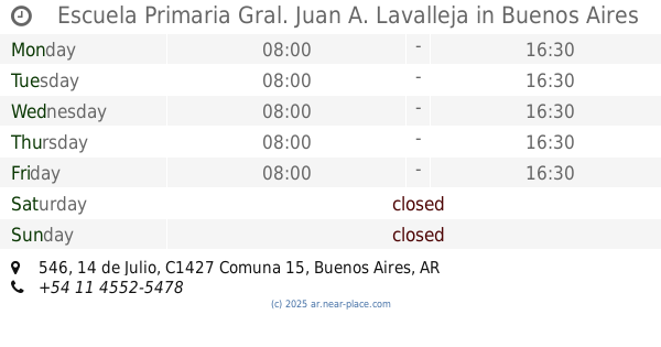
603 m
Escuela Primaria Gral. Juan A. Lavalleja
14 de Julio 546
School
read more
612 m
St. Therese of the Child Jesus
Quirós 2915
School
read more
615 m
Over Laboratorios
Avenida de los Constituyentes 2995
School
read more
764 m
Colegio Garcia Lorca
377, C1427CXA, Avenida Chorroarín 361
School
read more
878 m
Laboratorio di cucina - Donato De Santis
C1427DEN, Llerena 3030
School
read more
901 m
Escuela de Recuperación N° 14
Avenida Triunvirato 3626
School
read more
901 m
Recovery School No.14
Avenida Triunvirato 3626
School
read more
937 m
Cátedra de Sociología
School
read more
1.089 km
School Neuquén Province
Almirante F. J. Seguí 2580
School
read more
1.089 km
Escuela 13 DE 14 Provincia de Neuquén
Almirante F. J. Seguí 2580
School
read more
1.1 km
Automotores
Avenida Chorroarín 200, C1427CWO
School
read more
1.122 km
Tambo Ovino, UBA Veterinaria
Acceso A Chorroarín
School
read more
1.141 km
Escuela
14 de Julio, Roseti y
School
read more
1.15 km
Maco
Zabala 3975-3999, C1427DYI
School
read more
1.182 km
Coronel Ramon
coronel l falcón 4225
School
read more
1.21 km
Apoyo Escolar Elcano
Avenida Elcano 3899
School
read more
1.263 km
Escuela Sonica
Avenida Elcano 3835
School
read more
1.277 km
Betel
C1427CHP, Avenida Elcano 3802-3900
School
read more
📑
all categories
Accounting
Administrative area level 1
Administrative area level 2
Airport
Amusement park
Aquarium
Art gallery
Atm
Bakery
Bank
Bar
Beauty salon
Bicycle store
Book store
Bowling alley
Bus station
Cafe
Campground
Car dealer
Car rental
Car repair
Car wash
Casino
Cemetery
Church
City hall
Clothing store
Colloquial area
Convenience store
Country
Courthouse
Dentist
Department store
Doctor
Electrician
Electronics store
Embassy
Establishment
Finance
Fire station
Florist
Food
Funeral home
Furniture store
Gas station
General contractor
Grocery or supermarket
Gym
Hair care
Hardware store
Health
Hindu Temple
Home goods store
Hospital
Insurance agency
Intersection
Jewelry store
Laundry
Lawyer
Library
Light rail station
Liquor store
Local government office
Locality
Locksmith
Lodging
Meal delivery
Meal takeaway
Mosque
Movie rental
Movie theater
Moving company
Museum
Natural feature
Neighborhood
Night club
Painter
Park
Parking
Pet store
Pharmacy
Physiotherapist
Place of worship
Plumber
Point of interest
Police
Political
Post office
Premise
Real estate agency
Restaurant
Roofing contractor
Route
Rv park, camping
School
Shoe store
Shopping mall
Spa
Stadium
Storage
Store
Subpremise
Subway station
Supermarket
Synagogue
Taxi stand
Train station
Transit station
Travel agency
University
Veterinary care
Zoo
sublocality level 1
sublocality level 3
↑