School nearby Jardin de infantes barrio las agaves
Argentina
School nearby Jardin de infantes barrio las agaves
Jardin de infantes barrio las agaves
La Rioja Argentina
contacts phone
:
+54
Latitude:
-29.4263211
, Longitude:
-66.8423854
read more
nearest School
284 m
Escuela Azucena Mercedes Bazan de Aquines N�20
Independencia S/n, Patqu�a, la Rioja
School
read more
395 m
Ale Lujan
La Rioja
School
read more
432 m
Football school
Fray Justo Santa María de Oro 1099-1199, La Rioja
School
read more
432 m
Escuela De Futbol
Fray Justo Santa María de Oro 1099-1199, La Rioja
School
read more
454 m
Escuela 395
La Rioja
School
read more
476 m
English Tower
Turín 69-99, La Rioja
School
read more
559 m
EFPAP SPP
La Rioja
School
read more
596 m
Jardin De Infantes Asodimo
Unnamed Road
School
read more
599 m
Instituto Advance
199,, Blas Parera 99, La Rioja
School
read more
607 m
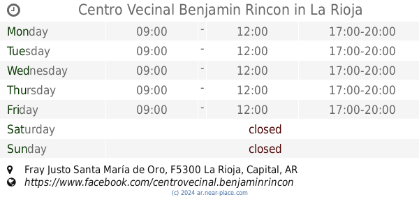
Centro Vecinal Benjamin Rincon
Fray Justo Santa María de Oro, La Rioja
School
read more
629 m
Escuela Nº 127 Capital Federal
y, Napoles & Turín, La Rioja
School
read more
719 m
Jardin De Infantes N° 4 Ovidio Decroli
944, Italia 900, La Rioja
School
read more
766 m
Escuela Integral Laboral 383
La Rioja
School
read more
789 m
Die Colegio de Nutricionistas
Carlos Quiroga 25, La Rioja
School
read more
902 m
Colegio de Kinesiologos y Fisioterapeutas de la Rioja
Napoles 535, La Rioja
School
read more
942 m
La Clandestina salsa
España 299-349, La Rioja
School
read more
946 m
Profe Hugo
La Rioja
School
read more
950 m
Instituto Privado London
Independencia 405, La Rioja
School
read more
1.012 km
Colegio Provincial N° 4
Juan de las Heras 1626-1680, La Rioja
School
read more
1.036 km
colegio sagrada familia Pigue
Moreno 550
School
read more
1.044 km
Apapachar
Republic de Siria 149, La Rioja
School
read more
1.146 km
LIVE INSTITUTO DE MATEMATICAS
Juan de las Heras 526, La Rioja
School
read more
1.223 km
Esc. Sarmiento
Avenida Facundo Quiroga 315, La Rioja
School
read more
1.789 km
Al Sama- Escuela De Danzas De Medio Oriente
Buenos Aires 166, La Rioja
School
read more
1.868 km
I.S.A.C
e, Santa Fe, Bernardo de Irigoyen
School
read more
📑
all categories
Accounting
Administrative area level 1
Administrative area level 2
Airport
Amusement park
Aquarium
Art gallery
Atm
Bakery
Bank
Bar
Beauty salon
Bicycle store
Book store
Bowling alley
Bus station
Cafe
Campground
Car dealer
Car rental
Car repair
Car wash
Casino
Cemetery
Church
City hall
Clothing store
Colloquial area
Convenience store
Country
Courthouse
Dentist
Department store
Doctor
Electrician
Electronics store
Embassy
Establishment
Finance
Fire station
Florist
Food
Funeral home
Furniture store
Gas station
General contractor
Grocery or supermarket
Gym
Hair care
Hardware store
Health
Hindu Temple
Home goods store
Hospital
Insurance agency
Intersection
Jewelry store
Laundry
Lawyer
Library
Light rail station
Liquor store
Local government office
Locality
Locksmith
Lodging
Meal delivery
Meal takeaway
Mosque
Movie rental
Movie theater
Moving company
Museum
Natural feature
Neighborhood
Night club
Painter
Park
Parking
Pet store
Pharmacy
Physiotherapist
Place of worship
Plumber
Point of interest
Police
Political
Post office
Premise
Real estate agency
Restaurant
Roofing contractor
Route
Rv park, camping
School
Shoe store
Shopping mall
Spa
Stadium
Storage
Store
Subpremise
Subway station
Supermarket
Synagogue
Taxi stand
Train station
Transit station
Travel agency
University
Veterinary care
Zoo
sublocality level 1
sublocality level 3
↑