School nearby +QDANZA
Argentina
School nearby +QDANZA
+QDANZA
Ruta Nacional 22, Confluencia, Neuquén, AR Argentina
contacts phone
:
+54
Latitude:
-38.9567348
, Longitude:
-68.2257079
larger map & directions
read more
nearest School
215 m
Biblioteca Carmen Mellado
Misiónes, Neuquén
School
read more
221 m
Escuela 98
Neuquén
School
read more
229 m
Esc 98
Aguas Claras, Neuquén
School
read more
444 m
C.P.E.M. N°8
Perito Moreno 277, Neuquén
School
read more
458 m
Salón Del Reino De Los Testigos De Jehová
Ernesto Bachmann 353, Neuquén
School
read more
499 m
Distrito Escolar X
Buenos Aires Sur 324-348, Neuquén
School
read more
528 m
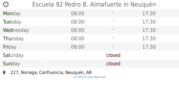
Escuela Primaria 92 Pedro B Palacios Almafuerte
Noriega 371, Neuquén
School
read more
538 m
Jardin Integral N* 39
Noriega 161, Plottier
School
read more
544 m
Escuela 92 Pedro B. Almafuerte
Noriega 227
School
read more
611 m
Escuela 60
Gobernador Elordi, Neuquén
School
read more
663 m
Jardin Construyendo
Buenos Aires Sur 8316, Plottier
School
read more
664 m
Colegio Reserch
Manuel Lainez, Neuquén
School
read more
678 m
Ipaf INTA
Alberdi, Neuquén
School
read more
681 m
Esc. Integral de Jovenes con Discapacidad N° 4
25 de mayo 125, Plottier
School
read more
700 m
Instituto De Ingles Springflied
Lucio Mansilla
School
read more
782 m
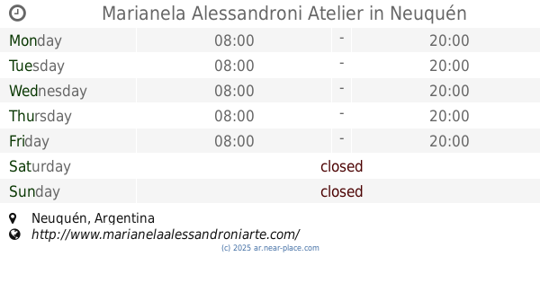
Marianela Alessandroni Atelier
Neuquén
School
read more
799 m
Jardin Mi Pequeño Gran Mundo
Brasil 229, Plottier
School
read more
826 m
Jardin de Infantes
Pulmarí 55
School
read more
828 m
taller de dubujo y tuntura decoratiba adi
Pulmarí 34, Plottier
School
read more
873 m
Escuela C.P.E.M. N°8
Perito Moreno, Neuquén
School
read more
900 m
Centro de Formación Profesional N° 14
Chile, Plottier
School
read more
900 m
Centro de Formación Profesional N° 14
Chile & Las Lajas, Plottier
School
read more
945 m
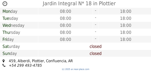
Jardin Integral N* 18
Alberdi 459, Plottier
School
read more
973 m
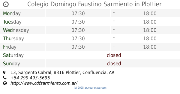
Colegio Domingo Faustino Sarmiento
Sargento Cabral 13, Plottier
School
read more
998 m
Anexo EPET N°9
Buenos Aires Norte 655, Neuquén
School
read more
📑
all categories
Accounting
Administrative area level 1
Administrative area level 2
Airport
Amusement park
Aquarium
Art gallery
Atm
Bakery
Bank
Bar
Beauty salon
Bicycle store
Book store
Bowling alley
Bus station
Cafe
Campground
Car dealer
Car rental
Car repair
Car wash
Casino
Cemetery
Church
City hall
Clothing store
Colloquial area
Convenience store
Country
Courthouse
Dentist
Department store
Doctor
Electrician
Electronics store
Embassy
Establishment
Finance
Fire station
Florist
Food
Funeral home
Furniture store
Gas station
General contractor
Grocery or supermarket
Gym
Hair care
Hardware store
Health
Hindu Temple
Home goods store
Hospital
Insurance agency
Intersection
Jewelry store
Laundry
Lawyer
Library
Light rail station
Liquor store
Local government office
Locality
Locksmith
Lodging
Meal delivery
Meal takeaway
Mosque
Movie rental
Movie theater
Moving company
Museum
Natural feature
Neighborhood
Night club
Painter
Park
Parking
Pet store
Pharmacy
Physiotherapist
Place of worship
Plumber
Point of interest
Police
Political
Post office
Premise
Real estate agency
Restaurant
Roofing contractor
Route
Rv park, camping
School
Shoe store
Shopping mall
Spa
Stadium
Storage
Store
Subpremise
Subway station
Supermarket
Synagogue
Taxi stand
Train station
Transit station
Travel agency
University
Veterinary care
Zoo
sublocality level 1
sublocality level 3
↑