School nearby School No. 24 D.E. 14. Francisco Beiró
Argentina
School nearby School No. 24 D.E. 14. Francisco Beiró
School No. 24 D.E. 14. Francisco Beiró
2569, Bolivia, C1417, Comuna 11, Buenos Aires, AR Argentina
contacts phone
:
+54 11 4581-5852
Latitude:
-34.6039509
, Longitude:
-58.481804
larger map & directions
read more
nearest School
300 m
Jardín Los Altos
Lascano 2776
School
read more
437 m
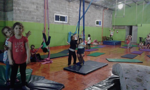
Resur Circo
General José Gervasio Artigas 2260
School
read more
575 m
Escuela 03 15
razabal, Av. Larrazabal & José Enrique Rodó
School
read more
590 m
Escola Hernan
Calfucura 2815
School
read more
659 m
Arquería Altai
Raulies 2043
School
read more
672 m
Territoria Talleres
School
read more
689 m
Profe Santi
Alfredo R. Bufano 2161, C1416AJS
School
read more
796 m
Platerillo
Terrada 3080
School
read more
821 m
INSTITUTO ST. MARY'S
Condarco 3142
School
read more
831 m
Shamrock Junior College
Baigorria 3054
School
read more
849 m
Automotores
Avenida Chorroarín 200, C1427CWO
School
read more
862 m
Bosque de Talar
Avenida Chorroarín 280
School
read more
864 m
escuela 10 de 17
C1417CQJ, Helguera 2435
School
read more
870 m
Iglesia Evangélica Bautista Villa Mitre
General José Gervasio Artigas 1897
School
read more
883 m
Ciclo básico común Paternales
C1417DSE, Avenida San Martín 4453
School
read more
947 m
Antonio Dellepiano
Baigorria 3169, Buenos Aires
School
read more
953 m
Melo Studio
Avenida Álvarez Jonte 1987
School
read more
962 m
Colegio Mane
Doctor Joaquín Zabala
School
read more
984 m
Esc Publica
Julio San Dantas 3264
School
read more
991 m
Virginia’s Classroom ‘Ingles para Todos’
Cuenca 1879
School
read more
1.122 km
Juego Hoy
General César Díaz 2453, C1416DVU
School
read more
1.124 km
Circodromo
Alejandro Magariños Cervantes 2177
School
read more
1.158 km
Clases de guitarra Sergio Sabbatini
Llavallol 2044
School
read more
1.166 km
Instituto GLAUX - Nivel Secundario
Avenida Nazca 3330
School
read more
1.381 km
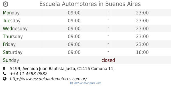
Escuela Automotores
C1416DJK, Avenida Juan Bautista Justo 5199
School
read more
📑
all categories
Accounting
Administrative area level 1
Administrative area level 2
Airport
Amusement park
Aquarium
Art gallery
Atm
Bakery
Bank
Bar
Beauty salon
Bicycle store
Book store
Bowling alley
Bus station
Cafe
Campground
Car dealer
Car rental
Car repair
Car wash
Casino
Cemetery
Church
City hall
Clothing store
Colloquial area
Convenience store
Country
Courthouse
Dentist
Department store
Doctor
Electrician
Electronics store
Embassy
Establishment
Finance
Fire station
Florist
Food
Funeral home
Furniture store
Gas station
General contractor
Grocery or supermarket
Gym
Hair care
Hardware store
Health
Hindu Temple
Home goods store
Hospital
Insurance agency
Intersection
Jewelry store
Laundry
Lawyer
Library
Light rail station
Liquor store
Local government office
Locality
Locksmith
Lodging
Meal delivery
Meal takeaway
Mosque
Movie rental
Movie theater
Moving company
Museum
Natural feature
Neighborhood
Night club
Painter
Park
Parking
Pet store
Pharmacy
Physiotherapist
Place of worship
Plumber
Point of interest
Police
Political
Post office
Premise
Real estate agency
Restaurant
Roofing contractor
Route
Rv park, camping
School
Shoe store
Shopping mall
Spa
Stadium
Storage
Store
Subpremise
Subway station
Supermarket
Synagogue
Taxi stand
Train station
Transit station
Travel agency
University
Veterinary care
Zoo
sublocality level 1
sublocality level 3
↑