Store nearby BAIC Argentina
Argentina
Store nearby BAIC Argentina
BAIC Argentina
8404, Avenida del Libertador, C1429, Comuna 13, Buenos Aires, AR Argentina
contacts phone
:
+54 11 4834-4800
website:
baic.com.ar
Latitude:
-34.5383236
, Longitude:
-58.4654739
larger map & directions
read more
nearest Store
45 m
Kiosco Kilómetro 0
Avenida del Libertador 8350
Store
read more
111 m
Mobile Solutions S.A.
Ramallo 1639
Store
read more
159 m
Puesto de Diarios y Revistas Junior
11 de Septiembre 4635
Store
read more
178 m
Loteria Nacional
11 de Septiembre 4652
Store
read more
280 m
MedicalFIT
11 de Septiembre 4246 oficina 2, Nuñez
Store
read more
398 m
Láser Games
Avenida Comodoro Martín Rivadavia 1420, Buenos Aires
Store
read more
467 m
Puerta Norte
Avenida del Libertador 85, Vicente López
Store
read more
663 m
Noble Argentina S.A.
Avenida del Libertador 174, Vicente López
Store
read more
719 m
Mas Visión Argentina
Avenida del Libertador 215
Store
read more
834 m
Daniel Helados
Avenida Cabildo 4401
Store
read more
867 m
Lotería Nacional
Avenida Cabildo 4778
Store
read more
882 m
Maxikiosko
Avenida Cabildo 4291, C1429ABA
Store
read more
884 m
Lotería Nacional
Arribeños 3599
Store
read more
900 m
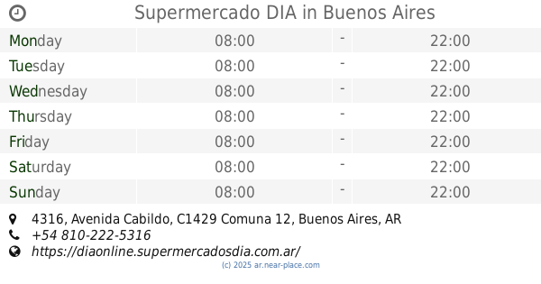
Supermercado DIA
Avenida Cabildo 4316
Supermarket
Grocery or supermarket
Store
Point of interest
Food
Establishment
read more
906 m
Carnicería y Granja Milagritos
Avenida Crisólogo Larralde 1788
Store
read more
917 m
RC Deportes
Avenida Cabildo 4191
Store
read more
924 m
Freeport
Avenida Crisólogo Larralde 1826
Store
read more
929 m
Fedimed S.A.
Avenida San Isidro Labrador 4473
Store
read more
934 m
David y Ramón Verdulería-carnicería
3 de Febrero 3584
Store
read more
980 m
Uzal Luis
11 de Septiembre 3502
Store
read more
999 m
Hidrozono
Núñez 1511
Store
read more
1.028 km
Farmacia Belladona Saavedra
C1430COD, Ramallo 3568
Store
read more
1.034 km
Maxikiosco Hindu
Av cabildo 3951
Store
read more
1.089 km
Pinta Que Te Pinta
Arias 2671
Store
read more
1.096 km
Kiosco Genesis
11 de Septiembre 3399
Store
read more
📑
all categories
Accounting
Administrative area level 1
Administrative area level 2
Airport
Amusement park
Aquarium
Art gallery
Atm
Bakery
Bank
Bar
Beauty salon
Bicycle store
Book store
Bowling alley
Bus station
Cafe
Campground
Car dealer
Car rental
Car repair
Car wash
Casino
Cemetery
Church
City hall
Clothing store
Colloquial area
Convenience store
Country
Courthouse
Dentist
Department store
Doctor
Electrician
Electronics store
Embassy
Establishment
Finance
Fire station
Florist
Food
Funeral home
Furniture store
Gas station
General contractor
Grocery or supermarket
Gym
Hair care
Hardware store
Health
Hindu Temple
Home goods store
Hospital
Insurance agency
Intersection
Jewelry store
Laundry
Lawyer
Library
Light rail station
Liquor store
Local government office
Locality
Locksmith
Lodging
Meal delivery
Meal takeaway
Mosque
Movie rental
Movie theater
Moving company
Museum
Natural feature
Neighborhood
Night club
Painter
Park
Parking
Pet store
Pharmacy
Physiotherapist
Place of worship
Plumber
Point of interest
Police
Political
Post office
Premise
Real estate agency
Restaurant
Roofing contractor
Route
Rv park, camping
School
Shoe store
Shopping mall
Spa
Stadium
Storage
Store
Subpremise
Subway station
Supermarket
Synagogue
Taxi stand
Train station
Transit station
Travel agency
University
Veterinary care
Zoo
sublocality level 1
sublocality level 3
↑