Store nearby Lotería Nacional Anel'o
Coronavirus disease (COVID-19) Situation
confirmed cases
10128845
deaths
130841
Argentina
Store nearby Lotería Nacional Anel'o
Lotería Nacional Anel'o
2928, Avenida Salvador María del Carril, C1419, Comuna 15, Buenos Aires, AR Argentina
contacts phone
:
+54
Latitude:
-34.590976
, Longitude:
-58.498399
larger map & directions
read more
nearest Store
214 m
Tango Ropa Femenina
y, Avenida Nazca
Store
read more
443 m
PAPAIO
Avenida Salvador María del Carril 2588
Store
read more
559 m
Megumi Regalos
Avenida San Martín 6038
Store
read more
586 m
Forma y Color
Gabriela Mistral 2700
Store
read more
596 m
Pañales para Adultos "Abu"
Andrés Vallejos 2588, Villa Pueyrredón
Store
read more
617 m
Supernatural
2884, Avenida General Mosconi
Store
read more
678 m
Equides Srl
Agustín Álvarez 4719, VILLA PUEYRREDON
Store
read more
714 m
Sold-Art
Avenida San Martín 5560
Store
read more
740 m
Ferreteria Fer San Villa del Parque
Avenida San Martín 5502
Store
read more
779 m
Absdad TDV
Cuenca 3453, P.2, ABG
Store
read more
780 m
La Papelera
Avenida General Mosconi 2560
Store
read more
784 m
ENERSOUTH
Helguera 3400
Store
read more
802 m
Carnicería M & M
EQY, Avenida General Mosconi 3288
Store
read more
809 m
world Fantasy 2
Cuenca 3445
Store
read more
823 m
Ivana
Avenida San Martín 6604
Store
read more
840 m
GPS Devoto
Avenida Francisco Beiró 3318
Store
read more
906 m
Can&Nos
Avenida Nazca 4924
Store
read more
951 m
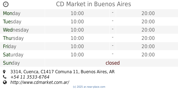
CD Market
Cuenca 3314
Store
read more
953 m
EZE HELADOS
Carlos Antonio López 3309
Store
read more
986 m
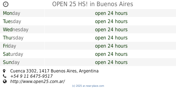
OPEN 25 HS!
Cuenca 3302
Store
read more
992 m
Optica
Avenida Nazca 3309, C1417CVD
Store
read more
1.124 km
HELADERIA SAN CAYETANO
Pedro Lozano 3000
Store
read more
1.158 km
DINGO PETS STORE
Mendoza 4499
Store
read more
1.179 km
Landa Automotores
Avenida Nazca
Store
read more
1.241 km
Libreria Brujitas
Ceretti 1996
Store
read more
📑
all categories
Accounting
Administrative area level 1
Administrative area level 2
Airport
Amusement park
Aquarium
Art gallery
Atm
Bakery
Bank
Bar
Beauty salon
Bicycle store
Book store
Bowling alley
Bus station
Cafe
Campground
Car dealer
Car rental
Car repair
Car wash
Casino
Cemetery
Church
City hall
Clothing store
Colloquial area
Convenience store
Country
Courthouse
Dentist
Department store
Doctor
Electrician
Electronics store
Embassy
Establishment
Finance
Fire station
Florist
Food
Funeral home
Furniture store
Gas station
General contractor
Grocery or supermarket
Gym
Hair care
Hardware store
Health
Hindu Temple
Home goods store
Hospital
Insurance agency
Intersection
Jewelry store
Laundry
Lawyer
Library
Light rail station
Liquor store
Local government office
Locality
Locksmith
Lodging
Meal delivery
Meal takeaway
Mosque
Movie rental
Movie theater
Moving company
Museum
Natural feature
Neighborhood
Night club
Painter
Park
Parking
Pet store
Pharmacy
Physiotherapist
Place of worship
Plumber
Point of interest
Police
Political
Post office
Premise
Real estate agency
Restaurant
Roofing contractor
Route
Rv park, camping
School
Shoe store
Shopping mall
Spa
Stadium
Storage
Store
Subpremise
Subway station
Supermarket
Synagogue
Taxi stand
Train station
Transit station
Travel agency
University
Veterinary care
Zoo
sublocality level 1
sublocality level 3
↑