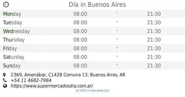
Supermarket nearby Día
Coronavirus disease (COVID-19) Situation
confirmed cases
10128845
deaths
130841
Argentina
Supermarket nearby Día
Día
2469, José Hernández, C1426, Buenos Aires, AR Argentina
contacts phone
:
+54 11 4867-6593
website:
www.supermercadosdia.com.ar
Latitude:
-34.5659368
, Longitude:
-58.4541971
larger map & directions
read more
nearest Supermarket
115 m
Carrefour Express
Virrey del Pino 2527
Supermarket
read more
177 m
Provision Pampa
La Pampa 2591
Supermarket
read more
209 m
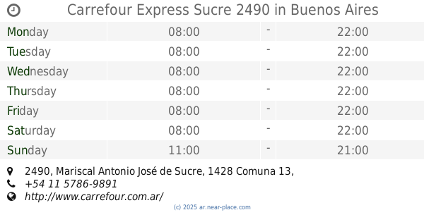
Carrefour Express Sucre 2490
Mariscal Antonio José de Sucre 2490
Supermarket
read more
224 m
Carrefour Express
Mariscal Antonio José de Sucre 2490
Supermarket
read more
257 m
Carrefour Express Moldes 1718
Moldes 1718
Supermarket
read more
257 m
Carrefour express
Moldes 1718
Supermarket
read more
357 m
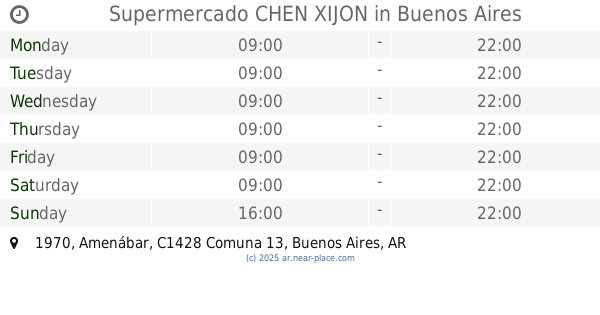
Supermercado CHEN XIJON
Amenábar 1970
Supermarket
read more
496 m
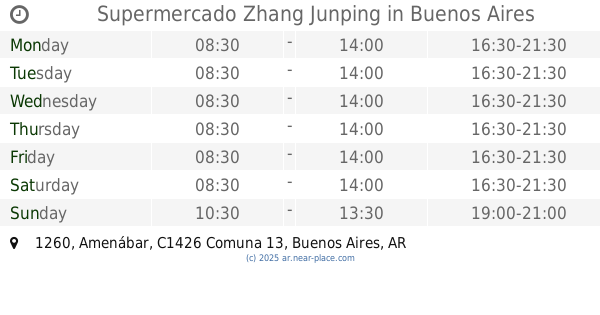
Supermercado Zhang Junping
Amenábar 1260
Supermarket
read more
545 m
SUPERLIDER
Vidal 2044
Supermarket
read more
559 m
Carrefour Express
Amenábar 1187
Supermarket
read more
576 m
COTO
Amenábar 2134
Supermarket
read more
687 m
Supermercado Buen Corazon
Zapiola 1729
Supermarket
read more
745 m
Supermercado Neil
Avenida Olazábal 2350
Supermarket
read more
745 m
Supermercado Neil
Olazábal 2350
Supermarket
read more
776 m
Autoservicio Santa María
Ciudad de La Paz 924
Supermarket
read more
840 m
Día
Amenábar 2369
Supermarket
read more
878 m
Carrefour Express
Vidal 2357, CSK
Supermarket
read more
884 m
La Gran Muralla China
3 de Febrero 2240
Supermarket
read more
919 m
Diana
Vidal 2377
Supermarket
read more
933 m
Carrefour Market
Avenida Cabildo 2441
Supermarket
read more
940 m
Carrefour Market Belgrano Cabildo
Avenida Cabildo 2441, Belgrano
Supermarket
read more
998 m
HUANG GUODONG
Echeverría 1602
Supermarket
read more
1.016 km
Supermercado Conesa
Conesa 820
Supermarket
read more
1.215 km
Carrefour Express
Amenábar 2702
Supermarket
read more
1.239 km
Carrefour Express Echeverría 1420
Echeverría 1420
Supermarket
read more
📑
all categories
Accounting
Administrative area level 1
Administrative area level 2
Airport
Amusement park
Aquarium
Art gallery
Atm
Bakery
Bank
Bar
Beauty salon
Bicycle store
Book store
Bowling alley
Bus station
Cafe
Campground
Car dealer
Car rental
Car repair
Car wash
Casino
Cemetery
Church
City hall
Clothing store
Colloquial area
Convenience store
Country
Courthouse
Dentist
Department store
Doctor
Electrician
Electronics store
Embassy
Establishment
Finance
Fire station
Florist
Food
Funeral home
Furniture store
Gas station
General contractor
Grocery or supermarket
Gym
Hair care
Hardware store
Health
Hindu Temple
Home goods store
Hospital
Insurance agency
Intersection
Jewelry store
Laundry
Lawyer
Library
Light rail station
Liquor store
Local government office
Locality
Locksmith
Lodging
Meal delivery
Meal takeaway
Mosque
Movie rental
Movie theater
Moving company
Museum
Natural feature
Neighborhood
Night club
Painter
Park
Parking
Pet store
Pharmacy
Physiotherapist
Place of worship
Plumber
Point of interest
Police
Political
Post office
Premise
Real estate agency
Restaurant
Roofing contractor
Route
Rv park, camping
School
Shoe store
Shopping mall
Spa
Stadium
Storage
Store
Subpremise
Subway station
Supermarket
Synagogue
Taxi stand
Train station
Transit station
Travel agency
University
Veterinary care
Zoo
sublocality level 1
sublocality level 3
↑