Supermarket nearby Supermercados Día
Argentina
Supermarket nearby Supermercados Día
Supermercados Día
Sanabria 2930, Villa Devoto Argentina
contacts phone
:
+54
Latitude:
-34.6096461
, Longitude:
-58.5078331
read more
nearest Supermarket
108 m
Carrefour Express
Sanabria 3039
Supermarket
read more
173 m
DADAÍS
Avenida Segurola 2845
Supermarket
read more
337 m
Autoservicio
Avenida Segurola 2576
Supermarket
read more
356 m
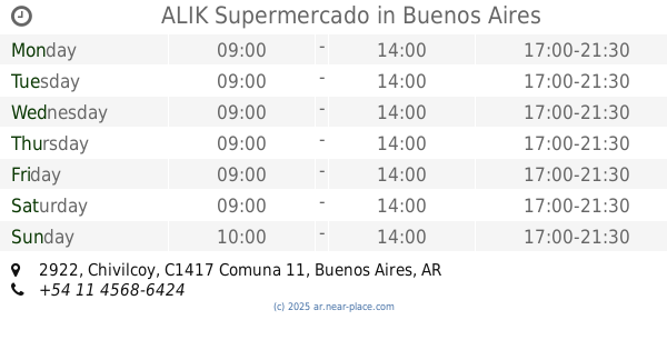
ALIK Supermercado
Chivilcoy 2922
Supermarket
read more
504 m
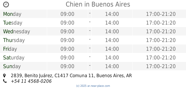
Chien
Benito Juárez 2839
Supermarket
read more
629 m
BEIRÓ
Avenida Francisco Beiró 4018
Supermarket
read more
693 m
Supermercado Chien
Avenida Segurola 2272
Supermarket
read more
704 m
Supermercado Día %
Avenida Francisco Beiró 4567
Supermarket
read more
717 m
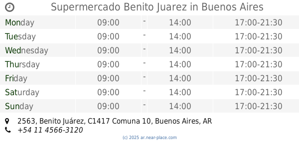
Supermercado Benito Juarez
Benito Juárez 2563
Supermarket
read more
767 m
super for you
C1417ASH, Bahía Blanca 2438
Supermarket
read more
771 m
Carrefour Hipermercado
José Pedro Varela 4750
Supermarket
Grocery or supermarket
Electronics store
Store
Food
Point of interest
Establishment
read more
800 m
Carrefour
José Pedro Varela 4750
Supermarket
read more
815 m
Inc José P Varela
C1417BSW, Desaguadero 3323
Supermarket
read more
849 m
Supermercado El As
Arregui 4664
Supermarket
read more
857 m
SUPERMERCADO ARGENCHINO
Gualeguaychú 2171
Supermarket
read more
962 m
Devoto
Santo Tomé 4955
Supermarket
read more
982 m
SUPERMERCADO SEGUROLA
Avenida Segurola 2062
Supermarket
read more
985 m
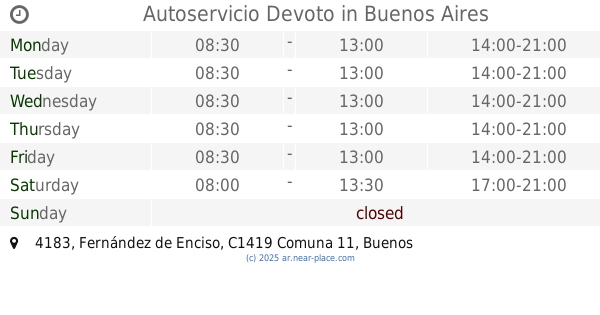
Autoservicio Devoto
Fernández de Enciso 4183
Supermarket
read more
990 m
Carrefour Express
Nogoyá 3664
Supermarket
read more
990 m
Carrefour Express
Nogoyá 3644
Supermarket
read more
1.041 km
Supermercados Día
Avenida Álvarez Jonte 4471
Supermarket
read more
1.043 km
Supermercado To To
Tinogasta 5050
Supermarket
read more
1.09 km
Supermercados DIA
Nogoyá 3529
Supermarket
read more
1.16 km
Supermercados DIA
Avenida Álvarez Jonte 4058
Supermarket
read more
1.204 km
Supermercado Chino
Llavallol 2922, C1417AER
Supermarket
read more
📑
all categories
Accounting
Administrative area level 1
Administrative area level 2
Airport
Amusement park
Aquarium
Art gallery
Atm
Bakery
Bank
Bar
Beauty salon
Bicycle store
Book store
Bowling alley
Bus station
Cafe
Campground
Car dealer
Car rental
Car repair
Car wash
Casino
Cemetery
Church
City hall
Clothing store
Colloquial area
Convenience store
Country
Courthouse
Dentist
Department store
Doctor
Electrician
Electronics store
Embassy
Establishment
Finance
Fire station
Florist
Food
Funeral home
Furniture store
Gas station
General contractor
Grocery or supermarket
Gym
Hair care
Hardware store
Health
Hindu Temple
Home goods store
Hospital
Insurance agency
Intersection
Jewelry store
Laundry
Lawyer
Library
Light rail station
Liquor store
Local government office
Locality
Locksmith
Lodging
Meal delivery
Meal takeaway
Mosque
Movie rental
Movie theater
Moving company
Museum
Natural feature
Neighborhood
Night club
Painter
Park
Parking
Pet store
Pharmacy
Physiotherapist
Place of worship
Plumber
Point of interest
Police
Political
Post office
Premise
Real estate agency
Restaurant
Roofing contractor
Route
Rv park, camping
School
Shoe store
Shopping mall
Spa
Stadium
Storage
Store
Subpremise
Subway station
Supermarket
Synagogue
Taxi stand
Train station
Transit station
Travel agency
University
Veterinary care
Zoo
sublocality level 1
sublocality level 3
↑