Supermarket nearby Wang
Coronavirus disease (COVID-19) Situation
confirmed cases
10128845
deaths
130841
Argentina
Supermarket nearby Wang
Wang
1885, Franklin D. Roosevelt, C1428, Comuna 13, Buenos Aires, AR Argentina
contacts phone
:
+54
Latitude:
-34.5549589
, Longitude:
-58.456289
larger map & directions
read more
nearest Supermarket
246 m
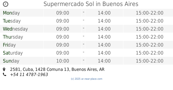
Supermercado Sol
Cuba 2581
Supermarket
read more
311 m
Supermercado Ugarte
Manuel Ugarte 2200
Supermarket
read more
463 m
SuperChungHwa
Olazabal 1673
Supermarket
read more
482 m
Huang Xiue
Avenida Olazábal 1645
Supermarket
read more
496 m
Carrefour Market Belgrano Cabildo
Avenida Cabildo 2441, Belgrano
Supermarket
read more
498 m
Carrefour Market
Avenida Cabildo 2441
Supermarket
read more
525 m
Quesada
Quesada 2185
Supermarket
read more
530 m
Carrefour Express
Avenida Cabildo 2865
Supermarket
read more
548 m
Supermercado Wong
Avenida del Libertador 6660
Supermarket
read more
560 m
Supermercado Chino
C1429BMN, Avenida del Libertador 6710
Supermarket
read more
569 m
Supermercado Neil
Avenida Olazábal 2350
Supermarket
read more
670 m
Supermercados DIA
Avenida del Libertador 6144
Supermarket
read more
713 m
Carrefour Express
Amenábar 2702
Supermarket
read more
850 m
HUANG GUODONG
Echeverría 1602
Supermarket
read more
861 m
Carrefour
Avenida Cabildo 3190
Supermarket
read more
887 m
Supermercado SEA
Avenida Congreso 2748
Supermarket
read more
900 m
COTO
Amenábar 2134
Supermarket
read more
927 m
Diana
Vidal 2377
Supermarket
read more
937 m
Carrefour Express
Vidal 2357, CSK
Supermarket
read more
972 m
Supermercado Pedraza
Manuela Pedraza 2364
Supermarket
read more
985 m
Carrefour Express Echeverría 1420
Echeverría 1420
Supermarket
read more
1.106 km
How How
Grecia 3570
Supermarket
read more
1.116 km
Carrefour Express Franklin D Roosevelt 3002
Franklin D. Roosevelt 3002
Supermarket
read more
1.142 km
Supermercado Los Primos
Avenida Cabildo 3567
Supermarket
read more
1.274 km
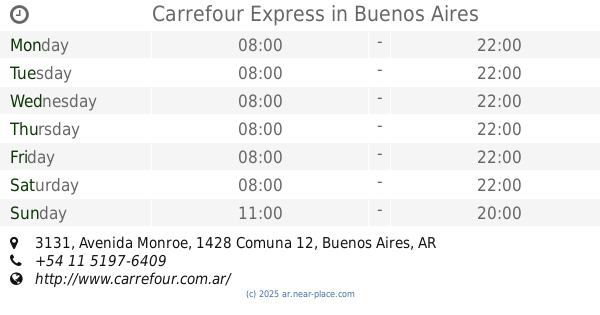
Carrefour Express
Avenida Monroe 3131
Supermarket
read more
📑
all categories
Accounting
Administrative area level 1
Administrative area level 2
Airport
Amusement park
Aquarium
Art gallery
Atm
Bakery
Bank
Bar
Beauty salon
Bicycle store
Book store
Bowling alley
Bus station
Cafe
Campground
Car dealer
Car rental
Car repair
Car wash
Casino
Cemetery
Church
City hall
Clothing store
Colloquial area
Convenience store
Country
Courthouse
Dentist
Department store
Doctor
Electrician
Electronics store
Embassy
Establishment
Finance
Fire station
Florist
Food
Funeral home
Furniture store
Gas station
General contractor
Grocery or supermarket
Gym
Hair care
Hardware store
Health
Hindu Temple
Home goods store
Hospital
Insurance agency
Intersection
Jewelry store
Laundry
Lawyer
Library
Light rail station
Liquor store
Local government office
Locality
Locksmith
Lodging
Meal delivery
Meal takeaway
Mosque
Movie rental
Movie theater
Moving company
Museum
Natural feature
Neighborhood
Night club
Painter
Park
Parking
Pet store
Pharmacy
Physiotherapist
Place of worship
Plumber
Point of interest
Police
Political
Post office
Premise
Real estate agency
Restaurant
Roofing contractor
Route
Rv park, camping
School
Shoe store
Shopping mall
Spa
Stadium
Storage
Store
Subpremise
Subway station
Supermarket
Synagogue
Taxi stand
Train station
Transit station
Travel agency
University
Veterinary care
Zoo
sublocality level 1
sublocality level 3
↑