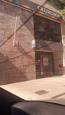
Atm nearby Red Link Credicoop
Argentina
Atm nearby Red Link Credicoop
Red Link Credicoop
6335, Avenida del Libertador, C1428, Comuna 13, Buenos Aires, AR Argentina
contacts phone
:
+54
Latitude:
-34.5533176
, Longitude:
-58.4500434
larger map & directions
read more
nearest Atm
16 m
ATM
Avenida del Libertador 6335, C1428ARG
Atm
read more
44 m
Santander Río ATM Banelco
Avenida del Libertador 6375
Atm
read more
49 m
ATM
Avenida del Libertador 6375, C1428ARG
Atm
read more
130 m
ATM
Avenida del Libertador 6401, 1428, Belgrano
Atm
read more
237 m
Santander Río
Avenida del Libertador 6156
Atm
read more
291 m
ATM
Avenida del Libertador 6597, C1428ARI
Atm
read more
648 m
ATM
Acceso A Avenida del Libertador 6876, C1429BMO
Atm
read more
726 m
Banelco
Av del Libertador 5755, CABA
Atm
read more
731 m
Banelco
C1428ARA, Avenida del Libertador 5755
Atm
read more
732 m
ATM
Avenida del Libertador 5767, C1428ARA
Atm
read more
840 m
ATM
Juramento 2095, C1428DNG
Atm
read more
1.039 km
ATM
Avenida Cabildo 2543, 1428, Belgrano
Atm
read more
1.076 km
ATM
Avenida Cabildo 2215
Atm
read more
1.097 km
Peru Services Courier
C1428AAS, Avenida Cabildo 2370
Atm
read more
1.213 km
ATM
Ciudad de La Paz 2175, C1428CPI
Atm
read more
1.213 km
ATM
Avenida Cabildo 1939, Buenos Aires
Atm
read more
1.289 km
Icbc
Avenida del Libertador 7461-7499, C1429BMH
Atm
read more
1.356 km
Banelco
Avenida Luis María Campos 1383
Atm
read more
1.396 km
ATM
La Pampa 2477, 1428
Atm
read more
1.581 km
Banelco
Avenida Luis María Campos 1201
Atm
read more
1.704 km
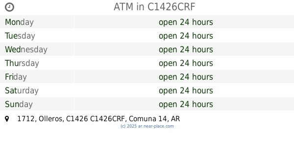
ATM
Olleros 1712, C1426CRF
Atm
read more
1.879 km
ATM
Crámer 1710, C1426APD
Atm
read more
1.91 km
Cajero Automático Banelco
Avenida Cabildo 769
Atm
read more
1.999 km
Cajero Automático Banco de la Nación Argentina
Paroissien 2443
Atm
Finance
Point of interest
Establishment
read more
2.177 km
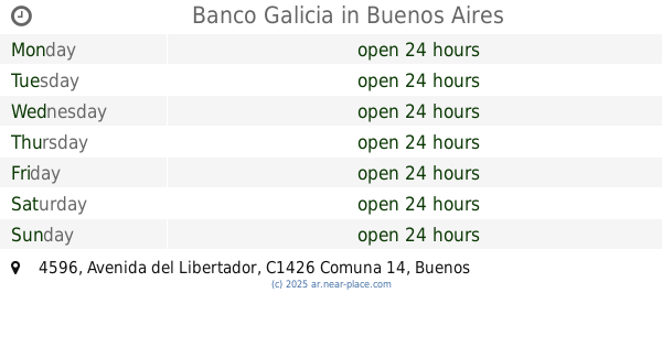
Banco Galicia
C1426BWT, Avenida del Libertador 4596
Atm
read more
📑
all categories
Accounting
Administrative area level 1
Administrative area level 2
Airport
Amusement park
Aquarium
Art gallery
Atm
Bakery
Bank
Bar
Beauty salon
Bicycle store
Book store
Bowling alley
Bus station
Cafe
Campground
Car dealer
Car rental
Car repair
Car wash
Casino
Cemetery
Church
City hall
Clothing store
Colloquial area
Convenience store
Country
Courthouse
Dentist
Department store
Doctor
Electrician
Electronics store
Embassy
Establishment
Finance
Fire station
Florist
Food
Funeral home
Furniture store
Gas station
General contractor
Grocery or supermarket
Gym
Hair care
Hardware store
Health
Hindu Temple
Home goods store
Hospital
Insurance agency
Intersection
Jewelry store
Laundry
Lawyer
Library
Light rail station
Liquor store
Local government office
Locality
Locksmith
Lodging
Meal delivery
Meal takeaway
Mosque
Movie rental
Movie theater
Moving company
Museum
Natural feature
Neighborhood
Night club
Painter
Park
Parking
Pet store
Pharmacy
Physiotherapist
Place of worship
Plumber
Point of interest
Police
Political
Post office
Premise
Real estate agency
Restaurant
Roofing contractor
Route
Rv park, camping
School
Shoe store
Shopping mall
Spa
Stadium
Storage
Store
Subpremise
Subway station
Supermarket
Synagogue
Taxi stand
Train station
Transit station
Travel agency
University
Veterinary care
Zoo
sublocality level 1
sublocality level 3
↑