Bakery nearby Itatí
Argentina
Bakery nearby Itatí
Itatí
1487, Avenida Luis María Campos, C1426, Comuna 13, Buenos Aires, AR Argentina
contacts phone
:
+54 11 4783-7909
Latitude:
-34.562937
, Longitude:
-58.443357
larger map & directions
read more
nearest Bakery
343 m
Tartas Crams
Avenida Luis María Campos 1226, C1426BOX
Bakery
read more
430 m
Mamía
Soldado de la Independencia 1177
Bakery
read more
654 m
Parada de Diarios O'Higgins y La Pampa
O'Higgins 1798
Bakery
read more
667 m
Buenos Aires Bakery.
Avenida del Libertador 5899, C1428ARB
Bakery
read more
691 m
Los Panes de Lili - Artesanía en panes centroeuropeos
Galería Beldomus, La Pampa 2041
Bakery
read more
714 m
CONFITERÍA Gran Norte
Montañeses 2023
Bakery
read more
759 m
Simona Panadería
Echeverría 1293
Bakery
read more
787 m
Hausbrot
Maure 1771
Bakery
read more
794 m
SAN RAFAEL
Juramento 1684
Bakery
read more
885 m
Il Vecchio
2274, La Pampa
Bakery
read more
893 m
Hausbrot
Juramento 1928
Bakery
read more
931 m
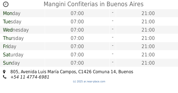
Mangini Confiterias
Avenida Luis María Campos 805
Bakery
read more
933 m
Mía Nonna
Ciudad de La Paz 1090
Bakery
read more
938 m
Manggini Panadería
Avenida Luis María Campos 799, C1426BOD
Bakery
read more
964 m
San Carlos
Ciudad de La Paz 1399
Bakery
read more
967 m
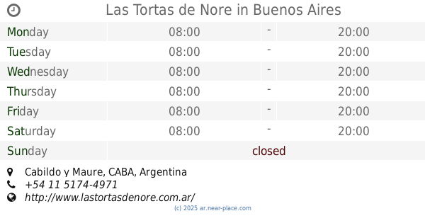
Las Tortas de Nore
Cabildo y Maure, Buenos Aires
Bakery
read more
971 m
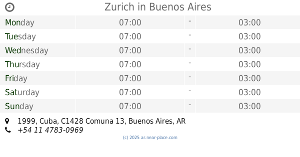
Zurich
Cuba 1999
Bakery
read more
1.032 km
El Artesano Confiteria
Báez 709
Bakery
read more
1.047 km
Panadería Bellaria
Teniente Benjamín Matienzo 1744
Bakery
read more
1.059 km
Panfe S.R.L.
Teniente Benjamín Matienzo 1987
Bakery
read more
1.073 km
Como en Casa
Céspedes 2647
Bakery
read more
1.164 km
Agalma Cakes
República de Eslovenia 1917
Bakery
read more
1.268 km
Buenos Aires Bakery
C1426BSH, Arce 502
Bakery
read more
1.308 km
Praliné Cakes
Avenida Monroe 1690
Bakery
read more
1.339 km
Anush
Avenida Monroe 1789
Bakery
read more
📑
all categories
Accounting
Administrative area level 1
Administrative area level 2
Airport
Amusement park
Aquarium
Art gallery
Atm
Bakery
Bank
Bar
Beauty salon
Bicycle store
Book store
Bowling alley
Bus station
Cafe
Campground
Car dealer
Car rental
Car repair
Car wash
Casino
Cemetery
Church
City hall
Clothing store
Colloquial area
Convenience store
Country
Courthouse
Dentist
Department store
Doctor
Electrician
Electronics store
Embassy
Establishment
Finance
Fire station
Florist
Food
Funeral home
Furniture store
Gas station
General contractor
Grocery or supermarket
Gym
Hair care
Hardware store
Health
Hindu Temple
Home goods store
Hospital
Insurance agency
Intersection
Jewelry store
Laundry
Lawyer
Library
Light rail station
Liquor store
Local government office
Locality
Locksmith
Lodging
Meal delivery
Meal takeaway
Mosque
Movie rental
Movie theater
Moving company
Museum
Natural feature
Neighborhood
Night club
Painter
Park
Parking
Pet store
Pharmacy
Physiotherapist
Place of worship
Plumber
Point of interest
Police
Political
Post office
Premise
Real estate agency
Restaurant
Roofing contractor
Route
Rv park, camping
School
Shoe store
Shopping mall
Spa
Stadium
Storage
Store
Subpremise
Subway station
Supermarket
Synagogue
Taxi stand
Train station
Transit station
Travel agency
University
Veterinary care
Zoo
sublocality level 1
sublocality level 3
↑