Bakery nearby La Nacional
Argentina
Bakery nearby La Nacional
La Nacional
507, Avenida Jujuy, C1229, Comuna 3, Buenos Aires, AR Argentina
contacts phone
:
+54
Latitude:
-34.6161029
, Longitude:
-58.404597
larger map & directions
read more
nearest Bakery
42 m
Mazzeo Juan E
Avenida Jujuy 500
Bakery
read more
422 m
La Reina
Avenida Belgrano 3052
Bakery
read more
422 m
La Marsellesa
Adolfo Alsina 2664
Bakery
read more
464 m
Panaderia Confiteria El Pan Nuestro
Matheu 763
Bakery
read more
469 m
Panadería el Sol once
México 3091
Bakery
read more
492 m
Flambo
Matheu 311
Bakery
read more
581 m
APACA ASOCIACIÓN PANADEROS CAPITAL
24 de Noviembre 438
Bakery
read more
707 m
Carmelo
Moreno 2228
Bakery
read more
731 m
La Primavera
Matheu 49
Bakery
read more
731 m
Le Mirage
Carlos Calvo 3002
Bakery
read more
742 m
Panadería La Vienesa
C1231ACD, Humberto 1º 2800
Bakery
read more
781 m
Peruar
24 de noviembre 108
Bakery
read more
843 m
Cruz Raúl
24 de Noviembre 62
Bakery
read more
853 m
Panadería Independencia Pastelería
Avenida Independencia 2090
Bakery
read more
858 m
Santa Rosa
Avenida Hipólito Yrigoyen 2215
Bakery
read more
868 m
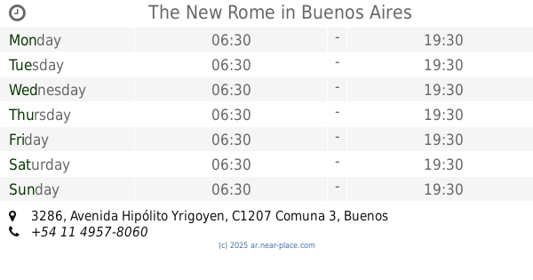
The New Rome
Avenida Hipólito Yrigoyen 3286
Bakery
read more
891 m
CaiCayen
Avenida Belgrano 3399
Bakery
read more
924 m
Santa Rosa Pastelería
Rincón 169
Bakery
read more
961 m
Panaderia los Molinos
Presidente Teniente General Juan Domingo Perón 2659
Bakery
read more
1.018 km
LA E PORTEÑA
Bartolomé Mitre 2242
Bakery
read more
1.061 km
La Boedo
Avenida Independencia 3474
Bakery
read more
1.11 km
La barcelonesa
Hipolito yrigoyen 1989
Bakery
read more
1.147 km
MIGUITAS
Presidente José Evaristo Uriburu 198
Bakery
read more
1.157 km
Gustos
Avenida San Juan 2102
Bakery
read more
1.23 km
La Primavera
Ayacucho 65
Bakery
read more
📑
all categories
Accounting
Administrative area level 1
Administrative area level 2
Airport
Amusement park
Aquarium
Art gallery
Atm
Bakery
Bank
Bar
Beauty salon
Bicycle store
Book store
Bowling alley
Bus station
Cafe
Campground
Car dealer
Car rental
Car repair
Car wash
Casino
Cemetery
Church
City hall
Clothing store
Colloquial area
Convenience store
Country
Courthouse
Dentist
Department store
Doctor
Electrician
Electronics store
Embassy
Establishment
Finance
Fire station
Florist
Food
Funeral home
Furniture store
Gas station
General contractor
Grocery or supermarket
Gym
Hair care
Hardware store
Health
Hindu Temple
Home goods store
Hospital
Insurance agency
Intersection
Jewelry store
Laundry
Lawyer
Library
Light rail station
Liquor store
Local government office
Locality
Locksmith
Lodging
Meal delivery
Meal takeaway
Mosque
Movie rental
Movie theater
Moving company
Museum
Natural feature
Neighborhood
Night club
Painter
Park
Parking
Pet store
Pharmacy
Physiotherapist
Place of worship
Plumber
Point of interest
Police
Political
Post office
Premise
Real estate agency
Restaurant
Roofing contractor
Route
Rv park, camping
School
Shoe store
Shopping mall
Spa
Stadium
Storage
Store
Subpremise
Subway station
Supermarket
Synagogue
Taxi stand
Train station
Transit station
Travel agency
University
Veterinary care
Zoo
sublocality level 1
sublocality level 3
↑