Bakery nearby Las Delicias de Flor
Argentina
Bakery nearby Las Delicias de Flor
Las Delicias de Flor
1025, Curapaligüe, C1406, Comuna 7, Buenos Aires, AR Argentina
contacts phone
:
+54 11 4923-1361
Latitude:
-34.6353356
, Longitude:
-58.4472702
larger map & directions
read more
nearest Bakery
279 m
Confitería Federico
Baldomero Fernández Moreno 1637
Bakery
read more
453 m
Panaderia y Confiteria El Sol
Avenida Carabobo 802
Bakery
read more
468 m
Boulevard Saenz II
Puan 752
Bakery
read more
518 m
Panadería Confitería Nogueira
Argentina
Bakery
read more
580 m
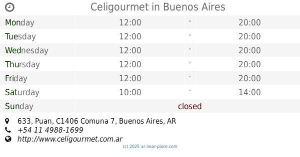
Celigourmet
Puan 633
Bakery
read more
588 m
Santina
Av. Asamblea 1130, Local 2
Bakery
read more
667 m
La Casa De Maga
Emilio Mitre 900
Bakery
read more
684 m
San Pablo
Emilio Mitre 300
Bakery
read more
730 m
Alo! Panadería Boutique
Curapaligüe 443
Bakery
read more
737 m
Los Leopoldo
Santander 2302
Bakery
read more
759 m
Dulces Tentaciones
Curapaligüe 439
Bakery
read more
812 m
La Central Chacabuco
Avenida Asamblea 945
Bakery
read more
867 m
Confitería Jesús & Jesús
Curapaligüe 317
Bakery
read more
896 m
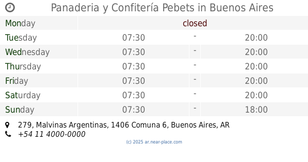
Panaderia y Confitería Pebets
Malvinas Argentinas 279
Bakery
read more
914 m
Le Petit I
Avenida Carabobo 297
Bakery
read more
938 m
AUTOSERVICIO SEA
Emilio Mitre 451
Bakery
read more
958 m
Stella Maris
Lautaro 295
Bakery
read more
963 m
Panadería boutique aló
Emilio Mitre 433
Bakery
read more
967 m
Que Bueno
Cachimayo 1497
Bakery
read more
1.113 km
CONFITERÍA - PANADERÍA LA CANOA
Avenida Varela 1257
Bakery
read more
1.174 km
Panadería & Confitería Bocattos
Coronel Ramón Lorenzo Falcón 1975
Bakery
read more
1.222 km
La Prometida
Avenida Cobo 1598
Bakery
read more
1.234 km
Erica & Adrián C. Cakes
Avenida Carabobo 37
Bakery
read more
1.246 km
La Nueva Dalma
Crespo 2028
Bakery
read more
1.285 km
Confitería Lautaro
Lautaro 30
Bakery
read more
📑
all categories
Accounting
Administrative area level 1
Administrative area level 2
Airport
Amusement park
Aquarium
Art gallery
Atm
Bakery
Bank
Bar
Beauty salon
Bicycle store
Book store
Bowling alley
Bus station
Cafe
Campground
Car dealer
Car rental
Car repair
Car wash
Casino
Cemetery
Church
City hall
Clothing store
Colloquial area
Convenience store
Country
Courthouse
Dentist
Department store
Doctor
Electrician
Electronics store
Embassy
Establishment
Finance
Fire station
Florist
Food
Funeral home
Furniture store
Gas station
General contractor
Grocery or supermarket
Gym
Hair care
Hardware store
Health
Hindu Temple
Home goods store
Hospital
Insurance agency
Intersection
Jewelry store
Laundry
Lawyer
Library
Light rail station
Liquor store
Local government office
Locality
Locksmith
Lodging
Meal delivery
Meal takeaway
Mosque
Movie rental
Movie theater
Moving company
Museum
Natural feature
Neighborhood
Night club
Painter
Park
Parking
Pet store
Pharmacy
Physiotherapist
Place of worship
Plumber
Point of interest
Police
Political
Post office
Premise
Real estate agency
Restaurant
Roofing contractor
Route
Rv park, camping
School
Shoe store
Shopping mall
Spa
Stadium
Storage
Store
Subpremise
Subway station
Supermarket
Synagogue
Taxi stand
Train station
Transit station
Travel agency
University
Veterinary care
Zoo
sublocality level 1
sublocality level 3
↑