Bakery nearby Oh My Pan
Argentina
Bakery nearby Oh My Pan
Oh My Pan
1452, Avenida Raúl Scalabrini Ortíz, C1414, Comuna 14, Buenos Aires, AR Argentina
contacts phone
:
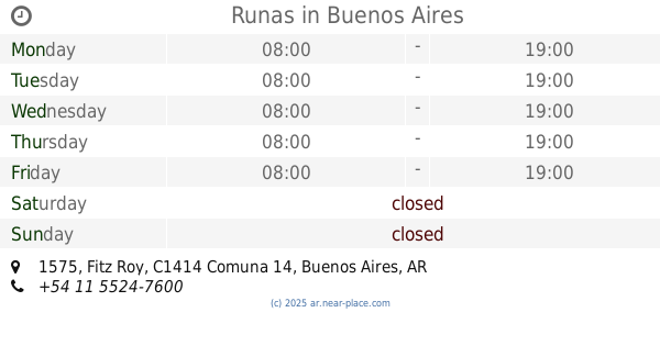
+54
Latitude:
-34.5917094
, Longitude:
-58.4264639
larger map & directions
read more
nearest Bakery
78 m
Pain de la vie
Honduras 4587, Palermo
Bakery
read more
230 m
Olten
Julián Álvarez
Bakery
read more
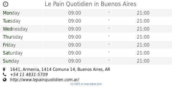
240 m
Le Pain Quotidien
Armenia 1641
Bakery
read more
376 m
Scarlett Soho
4457, Nicaragua
Bakery
read more
470 m
Fadymm II
Soler 4416
Bakery
read more
549 m
Le Ble
Honduras 4109
Bakery
read more
571 m
El cañón porteño
Lavalleja 1094
Bakery
read more
571 m
Lara
Lavalleja 1094
Bakery
read more
604 m
All you need is cupcakes!
Armenia 2116
Bakery
read more
614 m
Luiyi
Malabia 1076
Bakery
read more
711 m
Panaderia Confiteria La Estrella Del Plata
José Antonio Cabrera 5132
Bakery
read more
731 m
Confitería Ceres
Avenida Córdoba 3979
Bakery
read more
739 m
La Fábrica
Gascón 1100
Bakery
read more
778 m
Bellaria
Julián Álvarez 2097
Bakery
read more
788 m
PUNTA PALERMO
Paraguay 3920
Bakery
read more
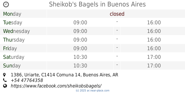
801 m
Sheikob's Bagels
Uriarte 1386
Bakery
read more
917 m
La Belle Dulce & Bistró
C1425BRZ, Paraguay 3758
Bakery
read more
947 m
Las Medialunas Del Abuelo
Jorge Luis Borges 2307
Bakery
read more
947 m
Crescents Del Abuelo Plaza Italia
Jorge Luis Borges 2307
Bakery
read more
1.002 km
Panadería Lorenzo
Avenida Medrano 921
Bakery
read more
1.007 km
Panadería La Nueva Almendra
Güemes 4202-4216
Bakery
read more
1.05 km
Panadería Nadiara
Avenida Medrano 889
Bakery
read more
1.177 km
Confectionery & Bakery Boulevard Cordoba
Avenida Córdoba 3502
Bakery
read more
1.233 km
Runas
Fitz Roy 1575
Bakery
read more
1.252 km
Buenas Costumbres panadería y confitería
C1414DRJ, Julián Álvarez 474
Bakery
read more
📑
all categories
Accounting
Administrative area level 1
Administrative area level 2
Airport
Amusement park
Aquarium
Art gallery
Atm
Bakery
Bank
Bar
Beauty salon
Bicycle store
Book store
Bowling alley
Bus station
Cafe
Campground
Car dealer
Car rental
Car repair
Car wash
Casino
Cemetery
Church
City hall
Clothing store
Colloquial area
Convenience store
Country
Courthouse
Dentist
Department store
Doctor
Electrician
Electronics store
Embassy
Establishment
Finance
Fire station
Florist
Food
Funeral home
Furniture store
Gas station
General contractor
Grocery or supermarket
Gym
Hair care
Hardware store
Health
Hindu Temple
Home goods store
Hospital
Insurance agency
Intersection
Jewelry store
Laundry
Lawyer
Library
Light rail station
Liquor store
Local government office
Locality
Locksmith
Lodging
Meal delivery
Meal takeaway
Mosque
Movie rental
Movie theater
Moving company
Museum
Natural feature
Neighborhood
Night club
Painter
Park
Parking
Pet store
Pharmacy
Physiotherapist
Place of worship
Plumber
Point of interest
Police
Political
Post office
Premise
Real estate agency
Restaurant
Roofing contractor
Route
Rv park, camping
School
Shoe store
Shopping mall
Spa
Stadium
Storage
Store
Subpremise
Subway station
Supermarket
Synagogue
Taxi stand
Train station
Transit station
Travel agency
University
Veterinary care
Zoo
sublocality level 1
sublocality level 3
↑