Bakery nearby Pan y Facturas
Argentina
Bakery nearby Pan y Facturas
Pan y Facturas
1486, República Árabe Siria, B1703, José Ingenieros, Tres de Febrero, AR Argentina
contacts phone
:
+54
Latitude:
-34.6207161
, Longitude:
-58.5350434
larger map & directions
read more
nearest Bakery
176 m
Los Milagros
B1703BAF, Eduardo Comesaña 2562, José Ingenieros
Bakery
read more
498 m
La Estrella
Asunción 2456, José Ingenieros
Bakery
read more
508 m
Confitería Bendiciones
Ciudadela
Bakery
read more
601 m
De Santino
Avenida Francisco Beiró 5741
Bakery
read more
649 m
IADASA (LA PERLA)
B1702AZI, Galileo 3035, Ciudadela
Bakery
read more
676 m
Panaderia Tío Nacho
Avenida Marcelo T. de Alvear 2768, José Ingenieros
Bakery
read more
682 m
Panaderia La Orquidea
Barragán 759, Ciudadela
Bakery
read more
864 m
Panadería Villarreal
Buenos Aires
Bakery
read more
864 m
Panadería Villarreal
Bakery
read more
883 m
Confitería Stella Maris
Avenida Marcelo T. de Alvear 3037, Gran Buenos Aires
Bakery
read more
892 m
La pana
Nogoyá 6159
Bakery
read more
892 m
Andy Gry
Nogoyá 6159
Bakery
read more
900 m
Confitería Lidia
Avenida Francisco Beiró 5497
Bakery
read more
922 m
Oh, mon Dieu! Pastelería Artesanal
Moliere 2798
Bakery
read more
940 m
Confitería Donna
Nogoyá 6001
Bakery
read more
949 m
Panadería Silvina
B1702EWL, Francisco Madero 1056, Ciudadela
Bakery
read more
1.064 km
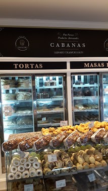
CABANAS
Avenida Francisco Beiró 5384
Bakery
read more
1.159 km
La Ideal
Avenida Lope de Vega 3500
Bakery
read more
1.17 km
Panadería y Confitería La Espiga
Avenida Lope de Vega 3345
Bakery
read more
1.176 km
Biscotti
Navarro 5284
Bakery
read more
1.197 km
PEPOCHO - Panadería, almuerzos y más...
3037- C1417CPC, Avenida Lope de Vega 3063
Bakery
read more
1.199 km
Panna Devoto
Avenida Lope de Vega 3039
Bakery
read more
1.244 km
Buonanotte Eduardo
Avenida Francisco Beiró 5264
Bakery
read more
1.248 km
El Favorito
Avenida Francisco Beiró 5262
Bakery
read more
1.269 km
Panadería y Confitería El Favorito
Avenida Francisco Beiró 5264
Bakery
read more
📑
all categories
Accounting
Administrative area level 1
Administrative area level 2
Airport
Amusement park
Aquarium
Art gallery
Atm
Bakery
Bank
Bar
Beauty salon
Bicycle store
Book store
Bowling alley
Bus station
Cafe
Campground
Car dealer
Car rental
Car repair
Car wash
Casino
Cemetery
Church
City hall
Clothing store
Colloquial area
Convenience store
Country
Courthouse
Dentist
Department store
Doctor
Electrician
Electronics store
Embassy
Establishment
Finance
Fire station
Florist
Food
Funeral home
Furniture store
Gas station
General contractor
Grocery or supermarket
Gym
Hair care
Hardware store
Health
Hindu Temple
Home goods store
Hospital
Insurance agency
Intersection
Jewelry store
Laundry
Lawyer
Library
Light rail station
Liquor store
Local government office
Locality
Locksmith
Lodging
Meal delivery
Meal takeaway
Mosque
Movie rental
Movie theater
Moving company
Museum
Natural feature
Neighborhood
Night club
Painter
Park
Parking
Pet store
Pharmacy
Physiotherapist
Place of worship
Plumber
Point of interest
Police
Political
Post office
Premise
Real estate agency
Restaurant
Roofing contractor
Route
Rv park, camping
School
Shoe store
Shopping mall
Spa
Stadium
Storage
Store
Subpremise
Subway station
Supermarket
Synagogue
Taxi stand
Train station
Transit station
Travel agency
University
Veterinary care
Zoo
sublocality level 1
sublocality level 3
↑