Bakery nearby PANADERÍA BLANES
Argentina
Bakery nearby PANADERÍA BLANES
PANADERÍA BLANES
128, Juan Manuel Blanes, C1155, Comuna 4, Buenos Aires, AR Argentina
contacts phone
:
+54 11 4361-1788
Latitude:
-34.628793
, Longitude:
-58.359971
larger map & directions
read more
nearest Bakery
175 m
Delgado Confitería
20 de Septiembre 228
Bakery
read more
225 m
La Esquina
20 de Septiembre 300
Bakery
read more
228 m
Panadería La Flor del Dia - Villa Mitre
Av Falucho y 20 de Septiembre, Bah�a Blanca, BUENOS AIRES
Bakery
read more
245 m
LUNAS Tucumanas CATALINAS
Necochea 578
Bakery
read more
249 m
Montesino
Necochea 647
Bakery
read more
368 m
PANADERÍA 775
Avenida Almirante Brown 775
Bakery
read more
386 m
Panaderia y Confiteria Dulzura's
Aristóbulo del Valle 199, Lanús Oeste
Bakery
read more
393 m
La Repúblicana
Avenida Almirante Brown 836
Bakery
read more
426 m
Las Familias
Aristóbulo del Valle 330
Bakery
read more
441 m
MVO Pastelería
Necochea 321
Bakery
read more
478 m
Lucas Panaderia y Confiteria
Necochea 223
Bakery
read more
507 m
La Mejor de la Boca
Avenida Almirante Brown 947
Bakery
read more
537 m
La Esquina II
Aristóbulo del Valle 497
Bakery
read more
659 m
Panaderia El Progreso
Avenida Almirante Brown 132
Bakery
read more
817 m
La Espiga Dorada
Argentina
Bakery
read more
832 m
Cono Sur Levaduras SRL
Avenida Juan de Garay 168, Buenos Aires
Bakery
read more
886 m
Panaderia San Juan
Olavarría 505
Bakery
read more
938 m
Panadería y confitería
Palos 680-700, C1160ACJ, Buenos Aires
Bakery
read more
987 m
El Progreso
Olavarría 628
Bakery
read more
1.095 km
Don Armando
Avenida San Juan 200, C1147AAN
Bakery
read more
1.11 km
Pan & Manteca
Pinzón 1084
Bakery
read more
1.145 km
Panaderia Y Confiteria Riviera
J L Su�rez 1002, Capital Federal, Capital Federal
Bakery
read more
1.149 km
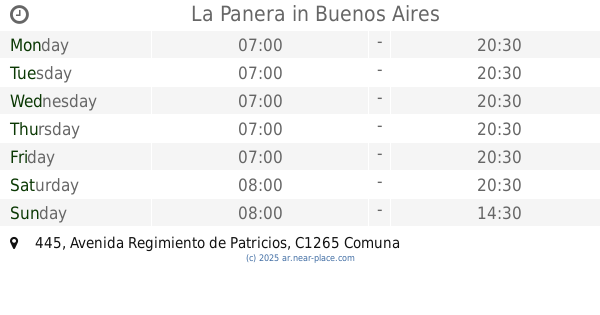
La Panera
Avenida Regimiento de Patricios 445
Bakery
read more
1.175 km
pan & churros, taller de pan
Wenceslao Villafañe 1261
Bakery
read more
1.92 km
Vasile Panadería & Confitería
Coronel Salvadores 1291
Bakery
read more
📑
all categories
Accounting
Administrative area level 1
Administrative area level 2
Airport
Amusement park
Aquarium
Art gallery
Atm
Bakery
Bank
Bar
Beauty salon
Bicycle store
Book store
Bowling alley
Bus station
Cafe
Campground
Car dealer
Car rental
Car repair
Car wash
Casino
Cemetery
Church
City hall
Clothing store
Colloquial area
Convenience store
Country
Courthouse
Dentist
Department store
Doctor
Electrician
Electronics store
Embassy
Establishment
Finance
Fire station
Florist
Food
Funeral home
Furniture store
Gas station
General contractor
Grocery or supermarket
Gym
Hair care
Hardware store
Health
Hindu Temple
Home goods store
Hospital
Insurance agency
Intersection
Jewelry store
Laundry
Lawyer
Library
Light rail station
Liquor store
Local government office
Locality
Locksmith
Lodging
Meal delivery
Meal takeaway
Mosque
Movie rental
Movie theater
Moving company
Museum
Natural feature
Neighborhood
Night club
Painter
Park
Parking
Pet store
Pharmacy
Physiotherapist
Place of worship
Plumber
Point of interest
Police
Political
Post office
Premise
Real estate agency
Restaurant
Roofing contractor
Route
Rv park, camping
School
Shoe store
Shopping mall
Spa
Stadium
Storage
Store
Subpremise
Subway station
Supermarket
Synagogue
Taxi stand
Train station
Transit station
Travel agency
University
Veterinary care
Zoo
sublocality level 1
sublocality level 3
↑