Bakery nearby Panadería - San Patricio
Coronavirus disease (COVID-19) Situation
confirmed cases
10128845
deaths
130841
Argentina
Bakery nearby Panadería - San Patricio
Panadería - San Patricio
Juramento, C1430, Comuna 12, Buenos Aires, AR Argentina
contacts phone
:
+54 11 4543-2969
Latitude:
-34.5719063
, Longitude:
-58.4731952
larger map & directions
read more
nearest Bakery
247 m
La Dulce Estación
Avenida Olazábal 3998
Bakery
read more
247 m
Dulce station
Avenida Olazábal 3998
Bakery
read more
264 m
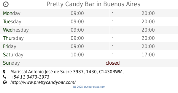
Pretty Candy Bar
Mariscal Antonio José de Sucre 3987, 1430, C1430BWM, Buenos Aires
Bakery
read more
547 m
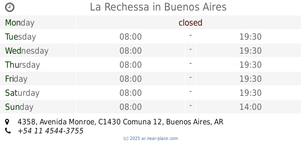
La Rechessa
Avenida Monroe 4358
Bakery
read more
608 m
Panadería Dulce Alegría
C1431FOO, Avenida Álvarez Thomas 2500
Bakery
read more
620 m
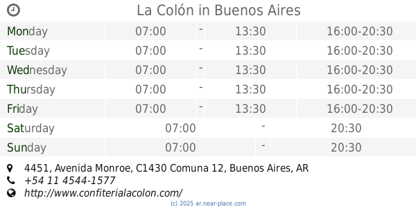
La Colón
Avenida Monroe 4451
Bakery
read more
645 m
Boulevard
Avenida Álvarez Thomas 2338
Bakery
read more
782 m
5 Estrellas
Juramento 4855
Bakery
read more
828 m
Di Zucchero Pasticceria
C1430FDB, Superí 1810
Bakery
read more
846 m
Panadería Feliz Prímavera
Plaza 2781
Bakery
read more
927 m
Europan
Avenida Triunvirato 3964
Bakery
read more
939 m
New Santa Paula
Avenida Triunvirato 4149
Bakery
read more
941 m
Un Dulce Permiso
Avenida Triunvirato 4099
Bakery
read more
947 m
La Argentina
Av. Forest 1502
Bakery
read more
972 m
Mis Delicias
Avenida Triunvirato 4284
Bakery
read more
986 m
El Encanto
Avenida Triunvirato 4284
Bakery
read more
1.005 km
Panadería Las Delicias
Avenida Triunvirato 3771
Bakery
read more
1.015 km
La Nonna Repostería
Avenida Triunvirato 4374
Bakery
read more
1.023 km
Malala
Juramento 5032
Bakery
read more
1.038 km
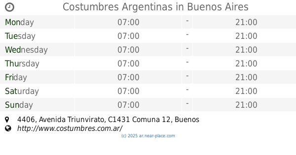
Costumbres Argentinas
Avenida Triunvirato 4406
Bakery
read more
1.043 km
Azahares y Canela
C1428CZG, Capitán General Ramón Freire 2359
Bakery
read more
1.085 km
The Bakery Take Away
Avenida Triunvirato 4484, Villa Urquiza
Bakery
read more
1.104 km
Guber Patisserie
Zapiola 2024
Bakery
read more
1.119 km
Rob-gus
Zapiola 2075
Bakery
read more
1.145 km
PANADERIA 4 SOLES
Echeverría 3087
Bakery
read more
📑
all categories
Accounting
Administrative area level 1
Administrative area level 2
Airport
Amusement park
Aquarium
Art gallery
Atm
Bakery
Bank
Bar
Beauty salon
Bicycle store
Book store
Bowling alley
Bus station
Cafe
Campground
Car dealer
Car rental
Car repair
Car wash
Casino
Cemetery
Church
City hall
Clothing store
Colloquial area
Convenience store
Country
Courthouse
Dentist
Department store
Doctor
Electrician
Electronics store
Embassy
Establishment
Finance
Fire station
Florist
Food
Funeral home
Furniture store
Gas station
General contractor
Grocery or supermarket
Gym
Hair care
Hardware store
Health
Hindu Temple
Home goods store
Hospital
Insurance agency
Intersection
Jewelry store
Laundry
Lawyer
Library
Light rail station
Liquor store
Local government office
Locality
Locksmith
Lodging
Meal delivery
Meal takeaway
Mosque
Movie rental
Movie theater
Moving company
Museum
Natural feature
Neighborhood
Night club
Painter
Park
Parking
Pet store
Pharmacy
Physiotherapist
Place of worship
Plumber
Point of interest
Police
Political
Post office
Premise
Real estate agency
Restaurant
Roofing contractor
Route
Rv park, camping
School
Shoe store
Shopping mall
Spa
Stadium
Storage
Store
Subpremise
Subway station
Supermarket
Synagogue
Taxi stand
Train station
Transit station
Travel agency
University
Veterinary care
Zoo
sublocality level 1
sublocality level 3
↑