Bakery nearby Sabores
Argentina
Bakery nearby Sabores
Sabores
1821, Ciudad de La Paz, C1428, Comuna 13, Buenos Aires, AR Argentina
contacts phone
:
+54 11 4786-6679
Latitude:
-34.5653065
, Longitude:
-58.4551032
larger map & directions
read more
nearest Bakery
236 m
Il Vecchio
2274, La Pampa
Bakery
read more
345 m
Panaderia Y Confiteria Nahuel II
Echeverría 2716
Bakery
read more
390 m
La Moderna
Juramento 2483
Bakery
read more
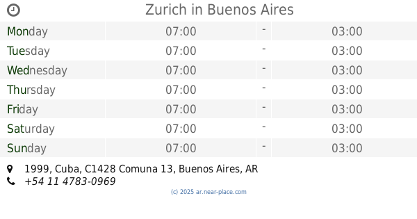
401 m
Zurich
Cuba 1999
Bakery
read more
438 m
La Argentina Confitería y Panadería
Avenida Crámer 1891
Bakery
read more
482 m
Amapola
C1428CTC, Avenida Crámer 1985
Bakery
read more
485 m
Los Panes de Lili - Artesanía en panes centroeuropeos
Galería Beldomus, La Pampa 2041
Bakery
read more
637 m
La Favorita
Avenida Olazábal 2583
Bakery
read more
664 m
Choklad Coffee and Patisserie
AUE, Zapiola 1575
Bakery
read more
684 m
PANADERIA 4 SOLES
Echeverría 3087
Bakery
read more
689 m
Hausbrot
Juramento 1928
Bakery
read more
711 m
Instituto Cecilia Morana
Virrey Avilés 3007
Bakery
read more
732 m
Rob-gus
Zapiola 2075
Bakery
read more
748 m
Mía Nonna
Ciudad de La Paz 1090
Bakery
read more
757 m
Como en Casa
Céspedes 2647
Bakery
read more
907 m
La Flor de Belgrano
Moldes 2498
Bakery
read more
910 m
Puerto Dulce
Cuba 2484
Bakery
read more
917 m
Boqueria Mercado Gourmet
Cap. Gral. Ramón Freire & Virrey Arredondo
Bakery
read more
989 m
Panadería Santa Ana
Conde 1502
Bakery
read more
1.018 km
Confitería La Capital
Franklin D. Roosevelt 2699
Bakery
read more
1.023 km
CONFITERÍA Gran Norte
Montañeses 2023
Bakery
read more
1.065 km
Las Delicias
Palpa 2900
Bakery
read more
1.102 km
Peek & Pie
Doctor Pedro Ignacio Rivera 2553, C1428BQC
Bakery
read more
1.105 km
Chantilly confiteria
Moldes 625
Bakery
read more
1.152 km
Buenos Aires Bakery.
Avenida del Libertador 5899, C1428ARB
Bakery
read more
📑
all categories
Accounting
Administrative area level 1
Administrative area level 2
Airport
Amusement park
Aquarium
Art gallery
Atm
Bakery
Bank
Bar
Beauty salon
Bicycle store
Book store
Bowling alley
Bus station
Cafe
Campground
Car dealer
Car rental
Car repair
Car wash
Casino
Cemetery
Church
City hall
Clothing store
Colloquial area
Convenience store
Country
Courthouse
Dentist
Department store
Doctor
Electrician
Electronics store
Embassy
Establishment
Finance
Fire station
Florist
Food
Funeral home
Furniture store
Gas station
General contractor
Grocery or supermarket
Gym
Hair care
Hardware store
Health
Hindu Temple
Home goods store
Hospital
Insurance agency
Intersection
Jewelry store
Laundry
Lawyer
Library
Light rail station
Liquor store
Local government office
Locality
Locksmith
Lodging
Meal delivery
Meal takeaway
Mosque
Movie rental
Movie theater
Moving company
Museum
Natural feature
Neighborhood
Night club
Painter
Park
Parking
Pet store
Pharmacy
Physiotherapist
Place of worship
Plumber
Point of interest
Police
Political
Post office
Premise
Real estate agency
Restaurant
Roofing contractor
Route
Rv park, camping
School
Shoe store
Shopping mall
Spa
Stadium
Storage
Store
Subpremise
Subway station
Supermarket
Synagogue
Taxi stand
Train station
Transit station
Travel agency
University
Veterinary care
Zoo
sublocality level 1
sublocality level 3
↑