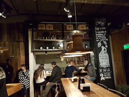
Bar nearby Clifton Jazz
Argentina
Bar nearby Clifton Jazz
Clifton Jazz
1480, Avenida Larrazábal, C1440, Comuna 9, Buenos Aires, AR Argentina
contacts phone
:
+54 11 4635-2164
website:
m.facebook.com
Latitude:
-34.651977
, Longitude:
-58.501284
larger map & directions
read more
nearest Bar
148 m
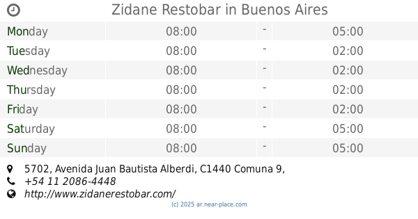
Zidane Restobar
Avenida Juan Bautista Alberdi 5702
Bar
read more
498 m
SG Soluciones SA
Chascomús 5949
Bar
read more
650 m
Si Te Pinta
Avenida Emilio Castro 5998, C1440CLV
Bar
read more
732 m
Pizarro
Pizarro 6265
Bar
read more
741 m
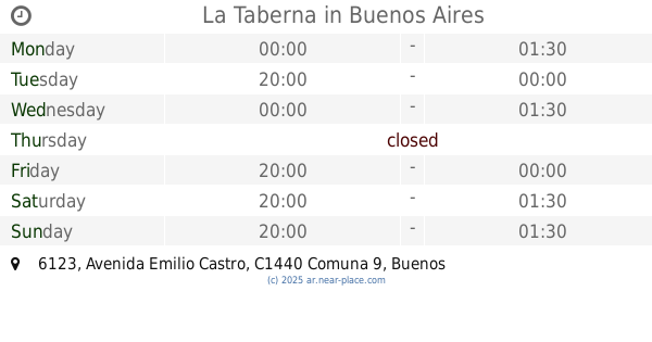
La Taberna
C1440CLK, Avenida Emilio Castro 6123
Bar
read more
790 m
Barhut
Basualdo 1171
Bar
read more
797 m
The Clubhouse
Chascomús
Bar
read more
858 m
Bar el Ciclon
José Enrique Rodó 6473
Bar
read more
862 m
Rune Resto Bar
Avenida Emilio Castro 5301
Bar
read more
864 m
La Coruña
Bragado 4997
Bar
read more
938 m
Pizzería La Paz
Avenida Juan Bautista Alberdi 6688
Bar
read more
951 m
Spilingese
Bar
read more
968 m
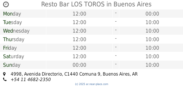
Resto Bar LOS TOROS
Avenida Directorio 4998
Bar
read more
1.048 km
La Casa Del Orejon
Donizetti 547, C1407IEK
Bar
read more
1.118 km
Il tempo restó & bar
C1407HGH, Avenida Directorio 4799
Bar
read more
1.163 km
VIEJA ALDEA
Avenida Juan Bautista Alberdi 4770
Bar
read more
1.263 km
El Torito De Mataderos
Bar
read more
1.719 km
Nomeacuerdo Bar
Avenida Juan Bautista Alberdi 4399
Bar
read more
1.781 km
Antares
Bar
read more
1.789 km
Belen Mariani
Primera Junta 5512
Bar
read more
1.807 km
Resto Bar El Francys
Avenida Rivadavia, Quimili
Bar
read more
1.83 km
Rock Café La Ve
Avenida Lope de Vega 250
Bar
read more
1.953 km
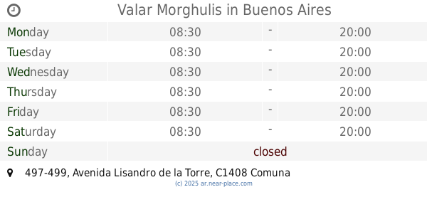
Valar Morghulis
Avenida Lisandro de la Torre 497-499
Bar
read more
2.209 km
El Bar
Avenida Lacarra 387
Bar
read more
2.492 km
Plaza Benedetti
Diputado Nac. Osvaldo Benedetti 102, C1407JUD
Bar
read more
📑
all categories
Accounting
Administrative area level 1
Administrative area level 2
Airport
Amusement park
Aquarium
Art gallery
Atm
Bakery
Bank
Bar
Beauty salon
Bicycle store
Book store
Bowling alley
Bus station
Cafe
Campground
Car dealer
Car rental
Car repair
Car wash
Casino
Cemetery
Church
City hall
Clothing store
Colloquial area
Convenience store
Country
Courthouse
Dentist
Department store
Doctor
Electrician
Electronics store
Embassy
Establishment
Finance
Fire station
Florist
Food
Funeral home
Furniture store
Gas station
General contractor
Grocery or supermarket
Gym
Hair care
Hardware store
Health
Hindu Temple
Home goods store
Hospital
Insurance agency
Intersection
Jewelry store
Laundry
Lawyer
Library
Light rail station
Liquor store
Local government office
Locality
Locksmith
Lodging
Meal delivery
Meal takeaway
Mosque
Movie rental
Movie theater
Moving company
Museum
Natural feature
Neighborhood
Night club
Painter
Park
Parking
Pet store
Pharmacy
Physiotherapist
Place of worship
Plumber
Point of interest
Police
Political
Post office
Premise
Real estate agency
Restaurant
Roofing contractor
Route
Rv park, camping
School
Shoe store
Shopping mall
Spa
Stadium
Storage
Store
Subpremise
Subway station
Supermarket
Synagogue
Taxi stand
Train station
Transit station
Travel agency
University
Veterinary care
Zoo
sublocality level 1
sublocality level 3
↑