Bar nearby Club De Cervezas
Argentina
Bar nearby Club De Cervezas
Club De Cervezas
268, Florencio Varela, Avenida Vicente López, Florencio Varela, Quilmes, AR Argentina
contacts phone
:
+54
Latitude:
-34.7174418
, Longitude:
-58.2701392
larger map & directions
read more
nearest Bar
242 m
Bura Cerveceria
San Juan 268-298, Quilmes
Bar
read more
270 m
Cosa de Duendes
Av Lamadrid 251, Bernal Este
Bar
read more
478 m
Eh?Park Paradise skatepark indoor
Otamendi Bis 108, Bernal
Cafe
Liquor store
Bar
School
Store
Restaurant
Food
Point of interest
Establishment
read more
804 m
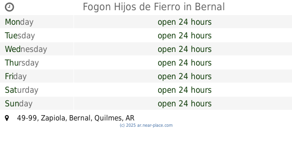
Fogon Hijos de Fierro
Zapiola 49-99, Bernal
Bar
read more
841 m
Bar muestra
Manuel Quintana 931-999, Quilmes
Bar
read more
851 m
Berlina La Escuela
Moreno 379, Quilmes
Bar
read more
862 m
SUM Barrio Parque Bernal
Carabelas 151-199, Bernal
Bar
read more
871 m
Berlina La Escuela
379, Moreno, Quilmes
Bar
read more
884 m
Cerveceria Quilmes
Lavalle 322-344, Quilmes
Bar
read more
890 m
The Beer Garage
Lavalle 343, Quilmes
Bar
read more
897 m
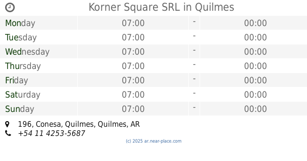
Korner Square SRL
Conesa 196, Quilmes
Bar
read more
968 m
El Alma
Quilmes
Bar
read more
984 m
Nandi
Nicolás Videla 88, Quilmes
Bar
read more
984 m
Don Carlos
Nicolás Videla 88, Quilmes
Bar
read more
1.005 km
Anden18
Avenida Hipólito Yrigoyen 515, Quilmes
Bar
read more
1.01 km
Bar Con Josefina
Colón 199-233, Quilmes
Bar
read more
1.035 km
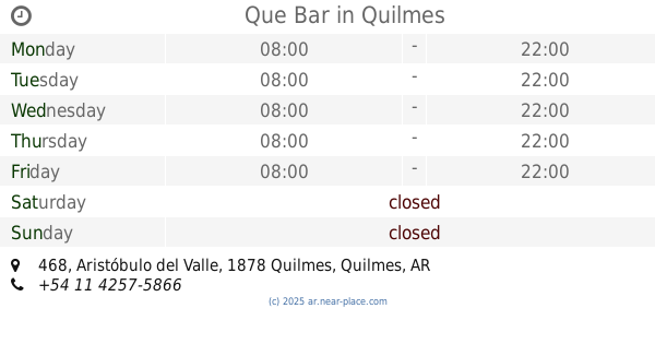
Que Bar
Aristóbulo del Valle 468, Quilmes
Bar
read more
1.051 km
El Colo
Gran Canaria 1226, Quilmes
Bar
read more
1.052 km
Baltimore
Nicolás Videla 149, Quilmes
Bar
read more
1.054 km
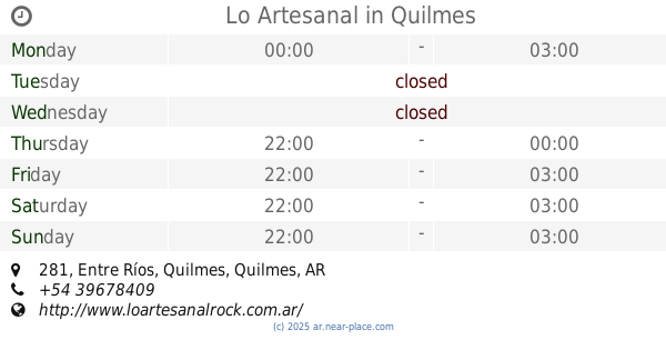
Lo Artesanal
Entre Ríos 281, Quilmes
Bar
read more
1.166 km
Cerveza Tero
Bernal
Bar
Restaurant
Point of interest
Food
Establishment
read more
1.19 km
Pancheria pablos
Hipólito Yrigoyen 625, Quilmes
Bar
read more
1.26 km
Biergarten
9 de Julio 17, Bernal Oeste
Bar
read more
1.263 km
La Roca Bar
9 de Julio 11, Gran Buenos Aires
Bar
read more
1.265 km
Biergarten
9 de Julio 17, Bernal
Bar
Restaurant
Point of interest
Food
Establishment
read more
📑
all categories
Accounting
Administrative area level 1
Administrative area level 2
Airport
Amusement park
Aquarium
Art gallery
Atm
Bakery
Bank
Bar
Beauty salon
Bicycle store
Book store
Bowling alley
Bus station
Cafe
Campground
Car dealer
Car rental
Car repair
Car wash
Casino
Cemetery
Church
City hall
Clothing store
Colloquial area
Convenience store
Country
Courthouse
Dentist
Department store
Doctor
Electrician
Electronics store
Embassy
Establishment
Finance
Fire station
Florist
Food
Funeral home
Furniture store
Gas station
General contractor
Grocery or supermarket
Gym
Hair care
Hardware store
Health
Hindu Temple
Home goods store
Hospital
Insurance agency
Intersection
Jewelry store
Laundry
Lawyer
Library
Light rail station
Liquor store
Local government office
Locality
Locksmith
Lodging
Meal delivery
Meal takeaway
Mosque
Movie rental
Movie theater
Moving company
Museum
Natural feature
Neighborhood
Night club
Painter
Park
Parking
Pet store
Pharmacy
Physiotherapist
Place of worship
Plumber
Point of interest
Police
Political
Post office
Premise
Real estate agency
Restaurant
Roofing contractor
Route
Rv park, camping
School
Shoe store
Shopping mall
Spa
Stadium
Storage
Store
Subpremise
Subway station
Supermarket
Synagogue
Taxi stand
Train station
Transit station
Travel agency
University
Veterinary care
Zoo
sublocality level 1
sublocality level 3
↑