Bar nearby Club Terrazo
Argentina
Bar nearby Club Terrazo
Club Terrazo
Cosquín, Córdoba, Argentina
contacts phone
:
+54
Latitude:
-31.2366429
, Longitude:
-64.4559249
larger map & directions
read more
nearest Bar
732 m
La Cueva Del Che
Tucumán 571, Cosquín
Bar
read more
739 m
Pisco Bar
Cosquín
Bar
read more
748 m
Ceibo Club
Obispo Bustos 628, Cosquín
Bar
read more
777 m
Lo De Jacinto
Tucumán 604, Cosquín
Bar
read more
872 m
Kilometro 36
Avenida San Martin 600, Córdoba
Bar
read more
887 m
Beggars Banquet - Cerveza Artesanal
Ruta Nacional 38, JRB
Bar
read more
897 m
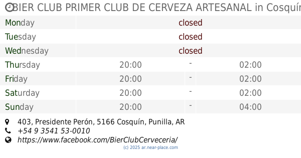
BIER CLUB PRIMER CLUB DE CERVEZA ARTESANAL
Presidente Perón 403, Cosquín
Bar
read more
979 m
Bar La Previa
Rvda.Madre Ana M.Janer
Bar
read more
1.011 km
Mosh
Avenida San Martin 854, Cosquín
Bar
read more
1.092 km
Kais Cafe Bar
Avenida San Martin 871, Cosquín
Bar
read more
1.092 km
El Cielo
Avenida San Martin 843, Cosquín
Bar
read more
1.12 km
GATO NEGRO
Presidente Perón 831, Cosquín
Bar
read more
1.128 km
El Gran Willi
J. C. Gerónico 813, Cosquín
Bar
read more
1.143 km
El Mantial Vinoteca y Chooperia
Jeronico 836, Cosquín
Bar
read more
1.252 km
Candilejas Bar
Av San Martín 1068, Cosquín
Bar
read more
1.323 km
Coco-Vik Kiosco Bar
Salta 771, Cosquín
Bar
read more
1.347 km
Candy Bar
Pres. Perón & Salta, Cosquín
Bar
read more
1.475 km
Mosh Pub
Córdoba
Bar
read more
3.947 km
BAR POOL EL SOPA
Avenida San Martin 2387, Santa María de Punilla
Bar
read more
4.556 km
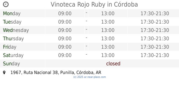
Vinoteca Rojo Ruby
Ruta Nacional 38 1967
Bar
read more
4.723 km
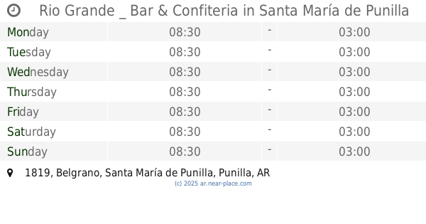
Rio Grande _ Bar & Confiteria
Belgrano 1819, Santa María de Punilla
Bar
read more
4.783 km
El Patio de la Nona
Ruta Nacional 38 1837
Bar
read more
4.832 km
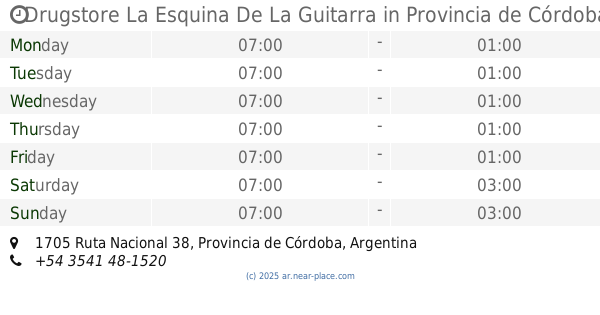
Drugstore La Esquina De La Guitarra
1705 Ruta Nacional 38
Bar
read more
4.961 km
La Casita Del Rock
1537,, Fermin Rodriguez, Santa María de Punilla
Bar
read more
15.327 km
La Cantina del Poli
Colón
Bar
read more
📑
all categories
Accounting
Administrative area level 1
Administrative area level 2
Airport
Amusement park
Aquarium
Art gallery
Atm
Bakery
Bank
Bar
Beauty salon
Bicycle store
Book store
Bowling alley
Bus station
Cafe
Campground
Car dealer
Car rental
Car repair
Car wash
Casino
Cemetery
Church
City hall
Clothing store
Colloquial area
Convenience store
Country
Courthouse
Dentist
Department store
Doctor
Electrician
Electronics store
Embassy
Establishment
Finance
Fire station
Florist
Food
Funeral home
Furniture store
Gas station
General contractor
Grocery or supermarket
Gym
Hair care
Hardware store
Health
Hindu Temple
Home goods store
Hospital
Insurance agency
Intersection
Jewelry store
Laundry
Lawyer
Library
Light rail station
Liquor store
Local government office
Locality
Locksmith
Lodging
Meal delivery
Meal takeaway
Mosque
Movie rental
Movie theater
Moving company
Museum
Natural feature
Neighborhood
Night club
Painter
Park
Parking
Pet store
Pharmacy
Physiotherapist
Place of worship
Plumber
Point of interest
Police
Political
Post office
Premise
Real estate agency
Restaurant
Roofing contractor
Route
Rv park, camping
School
Shoe store
Shopping mall
Spa
Stadium
Storage
Store
Subpremise
Subway station
Supermarket
Synagogue
Taxi stand
Train station
Transit station
Travel agency
University
Veterinary care
Zoo
sublocality level 1
sublocality level 3
↑