Bar nearby Cultural Freire Bar
Argentina
Bar nearby Cultural Freire Bar
Cultural Freire Bar
3116, Zabala, C1426, C1426DRH, Comuna 13, AR Argentina
contacts phone
:
+54
Latitude:
-34.5747372
, Longitude:
-58.454254
larger map & directions
read more
nearest Bar
208 m
42 NYC
ATZ, Zapiola 1220
Bar
read more
275 m
Loreto Garden Bar
Virrey Loreto 2912
Bar
read more
303 m
Multiespacio Alimme
Virrey Olaguer y Feliú 3117, Colegiales
Bar
read more
310 m
Social Club Buena Birra - Colegiales
Zapiola 1353
Bar
read more
387 m
Restó - Bar Alexander
Zabala 2825
Bar
read more
394 m
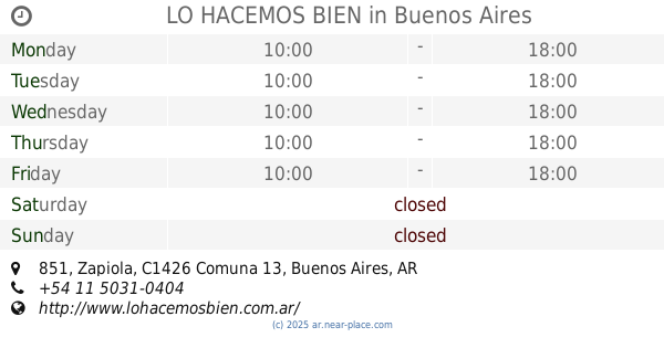
LO HACEMOS BIEN
C1426ATQ, Zapiola 851
Bar
read more
503 m
90 Grados
Delgado 1208
Bar
read more
543 m
Jack White Bar
Virrey Avilés 3383
Bar
read more
551 m
Ruda Bar
Crámer 824
Bar
read more
562 m
Roppongi Bar
Avenida Elcano 3487
Bar
read more
661 m
BORNEO BAR
Álvarez Thomas 635
Bar
read more
729 m
Milapizzería
Ciudad de La Paz 1080
Bar
read more
729 m
Kronopios
Avenida Elcano 3640
Bar
read more
733 m
Valentin
Zabala 2500, Buenos Aires
Bar
read more
869 m
La Beba (Tango)
Avenida Álvarez Thomas 1449
Bar
read more
903 m
Olleros Y Ciudad de La Paz
Olleros 2600-2502
Bar
read more
914 m
La casa de Belu y Fabri
C1426CPX, Avenida Federico Lacroze 2454
Bar
read more
932 m
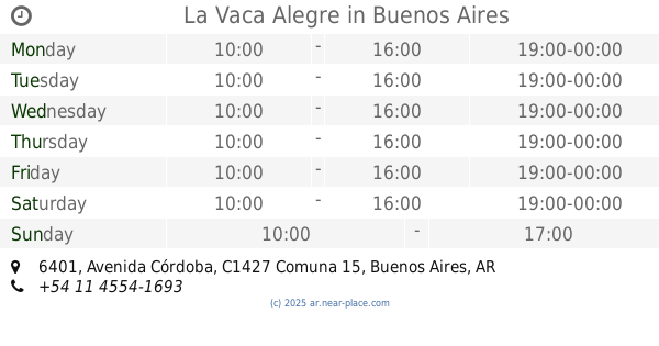
La Vaca Alegre
Avenida Córdoba 6401
Bar
read more
965 m
BAR EL POPULAR-CHACARITA
Avenida Federico Lacroze 3800
Bar
read more
1.003 km
Obligado Bar
Vuelta de Obligado 1183, C1426BEA
Bar
read more
1.054 km
Soraya
Avenida Cabildo 739
Bar
read more
1.172 km
Bar Plus Ultra
Echeverría 3155
Bar
read more
1.259 km
Mattina Bar
Avenida Álvarez Thomas 22
Bar
read more
1.264 km
Mattina
Avenida Álvarez Thomas 22, Palermo Hollywood
Bar
read more
1.325 km
Los Andes (Tango)
Avenida Dorrego 1578
Bar
read more
📑
all categories
Accounting
Administrative area level 1
Administrative area level 2
Airport
Amusement park
Aquarium
Art gallery
Atm
Bakery
Bank
Bar
Beauty salon
Bicycle store
Book store
Bowling alley
Bus station
Cafe
Campground
Car dealer
Car rental
Car repair
Car wash
Casino
Cemetery
Church
City hall
Clothing store
Colloquial area
Convenience store
Country
Courthouse
Dentist
Department store
Doctor
Electrician
Electronics store
Embassy
Establishment
Finance
Fire station
Florist
Food
Funeral home
Furniture store
Gas station
General contractor
Grocery or supermarket
Gym
Hair care
Hardware store
Health
Hindu Temple
Home goods store
Hospital
Insurance agency
Intersection
Jewelry store
Laundry
Lawyer
Library
Light rail station
Liquor store
Local government office
Locality
Locksmith
Lodging
Meal delivery
Meal takeaway
Mosque
Movie rental
Movie theater
Moving company
Museum
Natural feature
Neighborhood
Night club
Painter
Park
Parking
Pet store
Pharmacy
Physiotherapist
Place of worship
Plumber
Point of interest
Police
Political
Post office
Premise
Real estate agency
Restaurant
Roofing contractor
Route
Rv park, camping
School
Shoe store
Shopping mall
Spa
Stadium
Storage
Store
Subpremise
Subway station
Supermarket
Synagogue
Taxi stand
Train station
Transit station
Travel agency
University
Veterinary care
Zoo
sublocality level 1
sublocality level 3
↑