Bar nearby El Naranjo Tablao Flamenco
Coronavirus disease (COVID-19) Situation
confirmed cases
10128845
deaths
130841
Argentina
Bar nearby El Naranjo Tablao Flamenco
El Naranjo Tablao Flamenco
412, La Rioja, C1214, Comuna 3, Buenos Aires, AR Argentina
contacts phone
:
+54 11 4957-4137
website:
www.elnaranjo.com.ar
Latitude:
-34.6153805
, Longitude:
-58.408281
larger map & directions
read more
nearest Bar
341 m
PARRILLA ALVARITO
México 3055
Bar
read more
400 m
El Ranchito
Moreno 2738
Bar
read more
428 m
El gusto es nuestro
Adolfo Alsina 2800
Bar
read more
472 m
Cristobalino
Avenida Hipólito Yrigoyen 3152, Buenos Aires
Bar
read more
528 m
La cautiva pool
Catamarca 38 C1213ABB
Bar
read more
560 m
Carnicería once
Avenida Rivadavia 2936
Bar
read more
582 m
La Perla Bar
Avenida Jujuy 36
Bar
read more
666 m
La Rioja 12
C1034ACG, Avenida Rivadavia 2743
Bar
read more
728 m
Grill Gildo
Avenida Pueyrredón 39
Bar
read more
852 m
Bar de Cao
Av. Independencia 2400
Bar
read more
862 m
El Escorialito
Presidente Teniente General Juan Domingo Perón 2895
Bar
read more
887 m
Global Vinos
Argentina
Bar
read more
893 m
~MALU~ Pizza-Café
Carlos Calvo 2438
Bar
read more
900 m
Bar De Tapas Vinos Y Cervezas
Maza 846, C1220ABH
Bar
read more
923 m
El Franjamar
Moreno 2291
Bar
read more
944 m
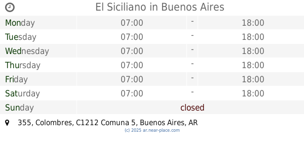
El Siciliano
Colombres 355
Bar
read more
969 m
Fernando Andres Cano
México
Bar
read more
969 m
La Esquina del KONEX
Sarmiento 3102
Bar
read more
981 m
El Luminoso Bar
Sarmiento 3101
Bar
read more
991 m
Bar Cervantes
B Mitre 2095, Once (Balvanera)
Bar
read more
993 m
Pausa Restó Bar
Avenida Jujuy 1130
Bar
read more
998 m
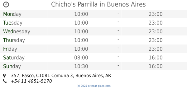
Chicho's Parrilla
Pasco 357
Bar
read more
1.046 km
El Viejo Bar
Teniente General Juan Domingo Perón 2513
Bar
read more
1.078 km
Restobar Fusas y Corcheas
Teniente General Juan Domingo Perón 2450
Bar
read more
1.121 km
Billares Alenjo
Avenida Boedo 801-859
Bar
read more
📑
all categories
Accounting
Administrative area level 1
Administrative area level 2
Airport
Amusement park
Aquarium
Art gallery
Atm
Bakery
Bank
Bar
Beauty salon
Bicycle store
Book store
Bowling alley
Bus station
Cafe
Campground
Car dealer
Car rental
Car repair
Car wash
Casino
Cemetery
Church
City hall
Clothing store
Colloquial area
Convenience store
Country
Courthouse
Dentist
Department store
Doctor
Electrician
Electronics store
Embassy
Establishment
Finance
Fire station
Florist
Food
Funeral home
Furniture store
Gas station
General contractor
Grocery or supermarket
Gym
Hair care
Hardware store
Health
Hindu Temple
Home goods store
Hospital
Insurance agency
Intersection
Jewelry store
Laundry
Lawyer
Library
Light rail station
Liquor store
Local government office
Locality
Locksmith
Lodging
Meal delivery
Meal takeaway
Mosque
Movie rental
Movie theater
Moving company
Museum
Natural feature
Neighborhood
Night club
Painter
Park
Parking
Pet store
Pharmacy
Physiotherapist
Place of worship
Plumber
Point of interest
Police
Political
Post office
Premise
Real estate agency
Restaurant
Roofing contractor
Route
Rv park, camping
School
Shoe store
Shopping mall
Spa
Stadium
Storage
Store
Subpremise
Subway station
Supermarket
Synagogue
Taxi stand
Train station
Transit station
Travel agency
University
Veterinary care
Zoo
sublocality level 1
sublocality level 3
↑