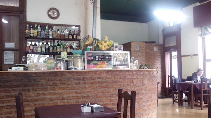
Bar nearby El Templo ..... Hogar
Argentina
Bar nearby El Templo ..... Hogar
El Templo ..... Hogar
2600, San Blas, C1416, Comuna 11, Buenos Aires, AR Argentina
contacts phone
:
+54
Latitude:
-34.6094115
, Longitude:
-58.4776131
larger map & directions
read more
nearest Bar
402 m
Green King Cervecería Artesanal
Avenida Nazca 1983
Bar
read more
435 m
Buenos Ayres Pizza Café
Avenida Nazca 1867
Bar
read more
437 m
Ciro Restó Bar
Avenida Nazca 2060
Bar
read more
471 m
Ciro Bar ll Café
Nazca 1801
Bar
read more
487 m
La Esquina Rosada
Avenida Nazca 1799, Villa Santa rita
Bar
read more
493 m
El Villano
2243, Avenida Nazca
Bar
read more
546 m
El Monito
Avenida Álvarez Jonte 2202
Bar
read more
677 m
Pallet Plastico 2
Adolfo P. Carranza 2228
Bar
read more
682 m
Che Diego
C1416ACZ, Bernardo de León 2507
Bar
read more
692 m
DOUGLAS BAR
Doctor Luis Beláustegui 2702
Bar
read more
752 m
BRODA ROCK & BAR
Avenida Nazca 1534
Bar
read more
784 m
Ariel Cocina de Autor
C1417HFO, Adolfo P. Carranza 3049
Bar
read more
816 m
Green Beer Planet
Condarco 2601
Bar
read more
839 m
Resto Bar Pizzería EL GRAN POROTO
Tres Arroyos 2805
Bar
read more
849 m
Star New
General José Gervasio Artigas 1372
Bar
read more
849 m
Star News
Castro Barros 533
Bar
read more
885 m
Eh parrillon
Empedrado y Bolivia
Bar
read more
886 m
La Parrillita
Empedrado 2601
Bar
read more
928 m
Resto Bar Sahores
Santo Tomé 2496
Bar
read more
962 m
Los nietos - Parrilla al carbón
Cuenca 2205
Bar
read more
969 m
Casa Del Bebee
Gavilán 7494
Bar
read more
1.037 km
QUE BIEN BAR
Tres Arroyos 2071
Bar
read more
1.042 km
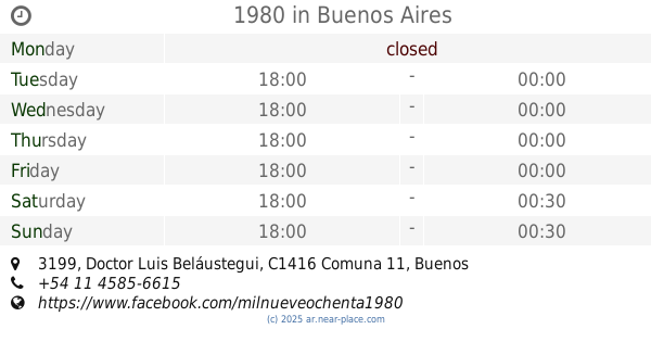
1980
CZM, Doctor Luis Beláustegui 3199
Bar
read more
1.195 km
El Balón
Avenida Gaona 3199
Bar
read more
1.208 km
HP Tower
Avenida Nazca 2900-2802, C1417CUR
Bar
read more
📑
all categories
Accounting
Administrative area level 1
Administrative area level 2
Airport
Amusement park
Aquarium
Art gallery
Atm
Bakery
Bank
Bar
Beauty salon
Bicycle store
Book store
Bowling alley
Bus station
Cafe
Campground
Car dealer
Car rental
Car repair
Car wash
Casino
Cemetery
Church
City hall
Clothing store
Colloquial area
Convenience store
Country
Courthouse
Dentist
Department store
Doctor
Electrician
Electronics store
Embassy
Establishment
Finance
Fire station
Florist
Food
Funeral home
Furniture store
Gas station
General contractor
Grocery or supermarket
Gym
Hair care
Hardware store
Health
Hindu Temple
Home goods store
Hospital
Insurance agency
Intersection
Jewelry store
Laundry
Lawyer
Library
Light rail station
Liquor store
Local government office
Locality
Locksmith
Lodging
Meal delivery
Meal takeaway
Mosque
Movie rental
Movie theater
Moving company
Museum
Natural feature
Neighborhood
Night club
Painter
Park
Parking
Pet store
Pharmacy
Physiotherapist
Place of worship
Plumber
Point of interest
Police
Political
Post office
Premise
Real estate agency
Restaurant
Roofing contractor
Route
Rv park, camping
School
Shoe store
Shopping mall
Spa
Stadium
Storage
Store
Subpremise
Subway station
Supermarket
Synagogue
Taxi stand
Train station
Transit station
Travel agency
University
Veterinary care
Zoo
sublocality level 1
sublocality level 3
↑