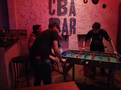
Bar nearby Food in Pack
Argentina
Bar nearby Food in Pack
Food in Pack
Bv. Juan Domingo Perón 316 Terminal Omnibus, X5000HYQ Córdoba, Argentina
contacts phone
:
+54 351 421-2440
Latitude:
-31.4225909
, Longitude:
-64.1751658
larger map & directions
read more
nearest Bar
230 m
Ofelia
Balcarce 355, Centro, Córdoba
Bar
read more
265 m
Bar-Comedor
Boulevard Juan Domingo Perón 152, Centro, Córdoba
Bar
read more
276 m
Belfast Cervecería Artesanal
Avenida Poeta Lugones 28-94, Córdoba
Bar
read more
441 m
Viña Lugones
X5000HZO, Avenida Poeta Lugones 178, Córdoba
Bar
read more
655 m
Party House
Paraná 660, Córdoba
Bar
read more
803 m
Gente Despierta Rock Bar
Rondeau 228, Córdoba
Bar
read more
803 m
People Awaken Rock Bar
Rondeau 228, Córdoba
Bar
read more
815 m
SushiWorld
Avenida 24 de Septiembre 738, Córdoba
Bar
read more
834 m
Baobab
Obispo Oro 370, Nueva Cordoba, Córdoba
Bar
read more
835 m
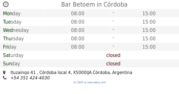
Bar Betoem
Ituzaíngo 41 , Córdoba local 4, Córdoba
Bar
read more
839 m
Bar del pasaje
Pasaje Emilio Huespe 155, Córdoba
Bar
read more
853 m
Graciela Bar
Ituzaingó 41, Córdoba
Bar
read more
866 m
BACANA
Rondeau 176, Córdoba
Bar
read more
911 m
Bonanza
Rondeau 150, Córdoba
Bar
read more
954 m
Holly Molly
X5000IMK, Buenos Aires 521, Córdoba
Bar
read more
960 m
Overnight Bar
Santiago Derqui 308, Córdoba
Bar
read more
979 m
Plan B Bar
Buenos Aires 524, Córdoba
Bar
read more
988 m
Benditos smoke house & beer
David Luque 6, Córdoba
Bar
read more
992 m
Bocados
25 de Mayo 1035, Córdoba
Liquor store
Bar
Cafe
Restaurant
Food
Point of interest
Store
Establishment
read more
1.026 km
Planta Alta Whiskey Bar
225, GXE, Santiago Derqui, Córdoba
Bar
read more
1.094 km
Discoteca Nazar Gómez Natalia Alejandra
Córdoba
Bar
read more
1.13 km
La Real
Av. Emilio Olmos 101, Centro, Córdoba
Bar
read more
1.147 km
Bar
Av Emilio F. Olmos 20, C�rdoba, Cordoba
Bar
read more
1.214 km
Amaranttos
EOA, Avenida Emilio Olmos 31, Córdoba
Bar
read more
1.22 km
Bonafide
EMA, 9 de Julio 75, X5000EMB
Cafe
Bar
Food
Point of interest
Establishment
read more
📑
all categories
Accounting
Administrative area level 1
Administrative area level 2
Airport
Amusement park
Aquarium
Art gallery
Atm
Bakery
Bank
Bar
Beauty salon
Bicycle store
Book store
Bowling alley
Bus station
Cafe
Campground
Car dealer
Car rental
Car repair
Car wash
Casino
Cemetery
Church
City hall
Clothing store
Colloquial area
Convenience store
Country
Courthouse
Dentist
Department store
Doctor
Electrician
Electronics store
Embassy
Establishment
Finance
Fire station
Florist
Food
Funeral home
Furniture store
Gas station
General contractor
Grocery or supermarket
Gym
Hair care
Hardware store
Health
Hindu Temple
Home goods store
Hospital
Insurance agency
Intersection
Jewelry store
Laundry
Lawyer
Library
Light rail station
Liquor store
Local government office
Locality
Locksmith
Lodging
Meal delivery
Meal takeaway
Mosque
Movie rental
Movie theater
Moving company
Museum
Natural feature
Neighborhood
Night club
Painter
Park
Parking
Pet store
Pharmacy
Physiotherapist
Place of worship
Plumber
Point of interest
Police
Political
Post office
Premise
Real estate agency
Restaurant
Roofing contractor
Route
Rv park, camping
School
Shoe store
Shopping mall
Spa
Stadium
Storage
Store
Subpremise
Subway station
Supermarket
Synagogue
Taxi stand
Train station
Transit station
Travel agency
University
Veterinary care
Zoo
sublocality level 1
sublocality level 3
↑