Bar nearby LOMITOS 348
Argentina
Bar nearby LOMITOS 348
LOMITOS 348
República de China 1045, Córdoba Argentina
contacts phone
:
+54
Latitude:
-31.377998
, Longitude:
-64.276763
read more
nearest Bar
589 m
Peñon del Aguila Valle Escondido
Córdoba
Bar
read more
986 m
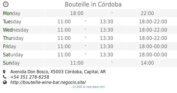
Bouteille
Mahatma Gandhi 446 Local 4, DWJ, Avenida Don Bosco, Córdoba
Bar
read more
1.883 km
Panaderia Valeria
Mirlo 298, Córdoba
Bar
read more
2.15 km
Foster Chateau
1199, X5016DQA, Avenida del Piamonte 1099, Córdoba
Bar
read more
2.205 km
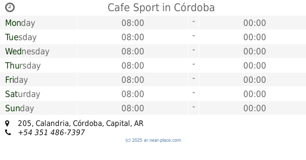
Cafe Sport
Calandria 205, Córdoba
Bar
read more
2.521 km
Barroco RestoBar
Ernestina López de Nelso, Córdoba
Bar
read more
2.746 km
Quebrada Restó
Avenida Colón 5653, Córdoba
Bar
read more
2.802 km
La Cabaña de Ariel
Carlos Federico Gauss 5110, Villa Belgrano, Córdoba
Bar
read more
2.821 km
La Cabaña de Ariel
Carlos Federico Gauss 5110, FGS
Bar
read more
2.872 km
Bar Comedor Tiro Federal Cordoba
Córdoba
Bar
read more
2.89 km
Estacionamiento Pontevecchio
X5003DBA, Cucha Cucha 5399-5499, Córdoba
Bar
read more
2.941 km
Dulce Lola
Ribereña 7300-7398, Córdoba
Bar
read more
3.47 km
Capricho
Avenida Colon 1313, Córdoba
Bar
read more
3.514 km
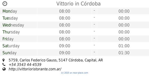
Vittorio
Carlos Federico Gauss 5759, Córdoba
Bar
read more
3.721 km
La Diagonal
Adrian Edgardo Douglas 6391, Quintas de Argüello, Córdoba
Bar
read more
3.89 km
Mr.Black
Avenida Recta Martinolli 5711, Córdoba
Bar
read more
3.942 km
Luna India
Avenida Recta Martinolli 5882, Córdoba
Bar
read more
4.07 km
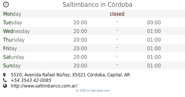
Saltimbanco
Avenida Rafael Núñez 5520, Córdoba
Bar
read more
4.08 km
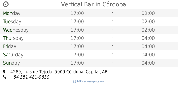
Vertical Bar
Luis de Tejeda 4289, Córdoba
Bar
read more
4.081 km
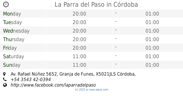
La Parra del Paso
Av. Rafael Núñez 5652, Granja de Funes, Córdoba
Bar
read more
4.207 km
Panicafe
X5009LDF, Gregorio Y. Gavier 2084, Córdoba
Bar
read more
4.48 km
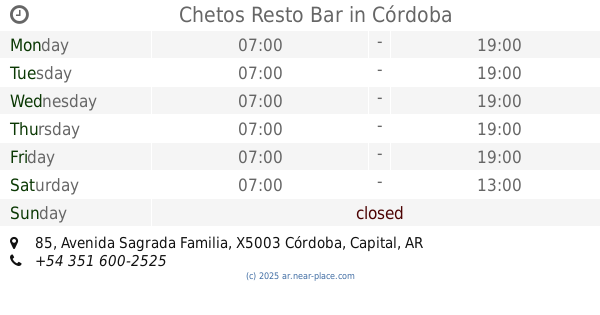
Chetos Resto Bar
X5003FGA, Avenida Sagrada Familia 85, Córdoba
Bar
read more
4.612 km
Vagon's
Ricardo Rojas 6900-6980, Córdoba
Bar
read more
4.88 km
Charly Bar
Cordoba
Bar
read more
6.428 km
Club
Angelo de Peredo 3249-3199, Córdoba
Bar
read more
📑
all categories
Accounting
Administrative area level 1
Administrative area level 2
Airport
Amusement park
Aquarium
Art gallery
Atm
Bakery
Bank
Bar
Beauty salon
Bicycle store
Book store
Bowling alley
Bus station
Cafe
Campground
Car dealer
Car rental
Car repair
Car wash
Casino
Cemetery
Church
City hall
Clothing store
Colloquial area
Convenience store
Country
Courthouse
Dentist
Department store
Doctor
Electrician
Electronics store
Embassy
Establishment
Finance
Fire station
Florist
Food
Funeral home
Furniture store
Gas station
General contractor
Grocery or supermarket
Gym
Hair care
Hardware store
Health
Hindu Temple
Home goods store
Hospital
Insurance agency
Intersection
Jewelry store
Laundry
Lawyer
Library
Light rail station
Liquor store
Local government office
Locality
Locksmith
Lodging
Meal delivery
Meal takeaway
Mosque
Movie rental
Movie theater
Moving company
Museum
Natural feature
Neighborhood
Night club
Painter
Park
Parking
Pet store
Pharmacy
Physiotherapist
Place of worship
Plumber
Point of interest
Police
Political
Post office
Premise
Real estate agency
Restaurant
Roofing contractor
Route
Rv park, camping
School
Shoe store
Shopping mall
Spa
Stadium
Storage
Store
Subpremise
Subway station
Supermarket
Synagogue
Taxi stand
Train station
Transit station
Travel agency
University
Veterinary care
Zoo
sublocality level 1
sublocality level 3
↑