Bar nearby Los Amigos
Argentina
Bar nearby Los Amigos
Los Amigos
6253, Avenida de los Constituyentes, C1431, Comuna 12, Buenos Aires, AR Argentina
contacts phone
:
+54
Latitude:
-34.5702601
, Longitude:
-58.5083243
larger map & directions
read more
nearest Bar
354 m
Bar El Mesón
Avenida de los Constituyentes 5991
Bar
read more
485 m
Sin Rumbo (Tango)
José Pascual Tamborini 6157
Bar
read more
586 m
Bar Artigas
General José Gervasio Artigas 5800
Bar
read more
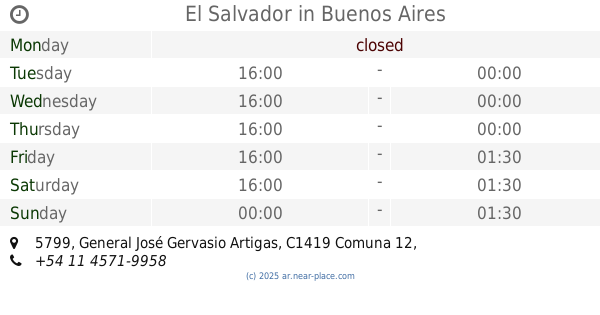
589 m
El Salvador
General José Gervasio Artigas 5799
Bar
read more
606 m
La Esquina
Avenida de los Constituyentes 5801
Bar
read more
700 m
Ratita
C1419FRF, Escobar 2586, Buenos Aires
Bar
read more
784 m
Parrilla Pequeño Demonio
C1431BJD, Rogelio Yrurtia 5776
Bar
read more
797 m
Bares Casa
Rogelio Yrurtia 6020
Bar
read more
925 m
La Casona
Avenida Presidente Arturo Illia 1701
Bar
read more
1.022 km
V8 Taller Cervecero
Avenida Congreso 5784
Bar
read more
1.038 km
Giuliano Cesarino
Avenida Congreso 5737
Bar
read more
1.256 km
Lo de Josu
Doctor Pedro Ignacio Rivera 5850, C1431BWB
Bar
read more
1.335 km
La Familia
Avenida Triunvirato 5701
Bar
read more
1.47 km
Charly Beer
Avenida Congreso 5286, C1431AAU, Buenos Aires
Bar
read more
1.495 km
Bar Franklin
5800, C1431BZT, Franklin D. Roosevelt 5748
Bar
read more
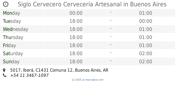
1.737 km
Siglo Cervecero Cervecería Artesanal
Iberá 5017
Bar
read more
1.764 km
Lo De Beer
Nahuel Huapi 5105
Bar
read more
1.798 km
Closet Bar
AAE, Avenida Congreso 4991
Bar
read more
1.835 km
Fullescabio
Avenida Monroe 5375, Villa Urquiza
Bar
read more
1.956 km
BlueDog Urquiza
Bucarelli 2340, C1431DQT
Bar
read more
2.011 km
Regionales Mendoza
C1431DNT, Bauness 2384
Bar
read more
2.032 km
Maldita Malta
Avenida Olazábal 5241
Bar
read more
2.11 km
Vinos Irina
José Cubas 2729
Bar
read more
2.405 km
Gott - Burger & Beer
Avenida de los Constituyentes 4101
Bar
read more
2.576 km
PULPERÍA SIGLO XX
Avenida de los Constituyentes 3939
Bar
read more
📑
all categories
Accounting
Administrative area level 1
Administrative area level 2
Airport
Amusement park
Aquarium
Art gallery
Atm
Bakery
Bank
Bar
Beauty salon
Bicycle store
Book store
Bowling alley
Bus station
Cafe
Campground
Car dealer
Car rental
Car repair
Car wash
Casino
Cemetery
Church
City hall
Clothing store
Colloquial area
Convenience store
Country
Courthouse
Dentist
Department store
Doctor
Electrician
Electronics store
Embassy
Establishment
Finance
Fire station
Florist
Food
Funeral home
Furniture store
Gas station
General contractor
Grocery or supermarket
Gym
Hair care
Hardware store
Health
Hindu Temple
Home goods store
Hospital
Insurance agency
Intersection
Jewelry store
Laundry
Lawyer
Library
Light rail station
Liquor store
Local government office
Locality
Locksmith
Lodging
Meal delivery
Meal takeaway
Mosque
Movie rental
Movie theater
Moving company
Museum
Natural feature
Neighborhood
Night club
Painter
Park
Parking
Pet store
Pharmacy
Physiotherapist
Place of worship
Plumber
Point of interest
Police
Political
Post office
Premise
Real estate agency
Restaurant
Roofing contractor
Route
Rv park, camping
School
Shoe store
Shopping mall
Spa
Stadium
Storage
Store
Subpremise
Subway station
Supermarket
Synagogue
Taxi stand
Train station
Transit station
Travel agency
University
Veterinary care
Zoo
sublocality level 1
sublocality level 3
↑