Bar nearby Los Chatitos
Argentina
Bar nearby Los Chatitos
Los Chatitos
1010, Urquiza, Salta, Capital, AR Argentina
contacts phone
:
+54 3876 20-1064
website:
www.facebook.com
Latitude:
-24.7918618
, Longitude:
-65.4169046
larger map & directions
read more
nearest Bar
190 m
Abalos Regionales
Islas Malvinas 295, Salta
Bar
read more
258 m
Paseo Bar Salta
Esteco 160, Capital
Bar
read more
302 m
Mooma
Gorriti 80, Salta
Bar
read more
333 m
Algo Distinto
Gorriti 80, Salta
Bar
read more
574 m
Dip Agencia De Tombola
Simón Bolívar 99, Salta
Bar
read more
590 m
Papa Panchio
Alberdi 269-299, Salta
Bar
read more
598 m
Charco's Sh
25 de Mayo 201, Salta
Bar
read more
601 m
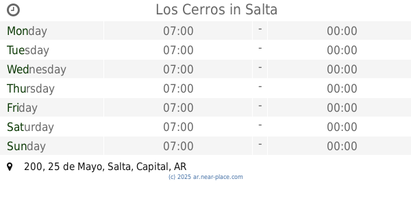
Los Cerros
25 de Mayo 200, Salta
Bar
read more
620 m
La Estancia
San Luis 810, Salta
Bar
read more
663 m
El Argentino
Centro Argentino, Avenida Sarmiento 277, Salta
Bar
read more
672 m
Bar Museo Arqueologico Alta Montaña
B Mitre 77, Salta
Bar
read more
684 m
Bartom
Avenida Belgrano 696, Salta
Bar
read more
699 m
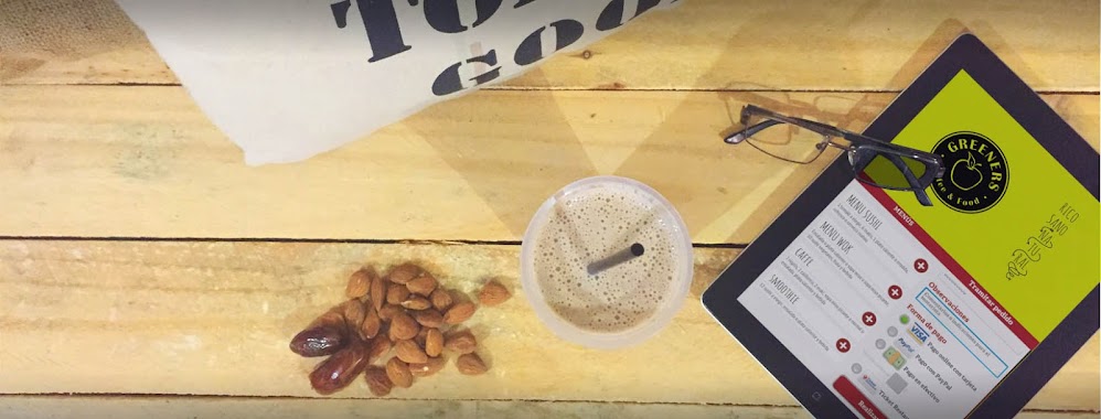
GREENERS Coffee & Food
Balcarce 218, Salta
Bar
read more
727 m
Vinería Borra & Vino
Buenos Aires 46, Galería Salta, Local 2, Salta
Bar
read more
785 m
Tiempo de Plaza
Zuviría 16, Salta
Bar
read more
845 m
Insomnio Bar & Pub
Miramar 433, Salta
Bar
read more
850 m
Bar rojo partido
Buenos Aires 503, Salta
Bar
read more
865 m
Amarú
Córdoba 350, Salta
Bar
read more
874 m
Kaetano III
Córdoba 366, Salta
Bar
read more
885 m
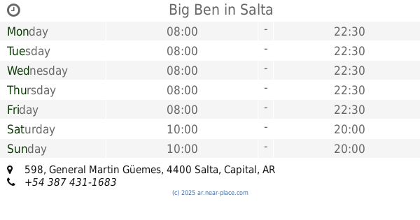
Big Ben
General Martin Güemes 598, Salta
Bar
read more
951 m
Cafe Al Paso
Alvarado 426, 4400, Salta
Bar
read more
972 m
Picado Fino Bar
Deán Funes 171, Salta
Bar
read more
988 m
Fábrica de Música Bandas & Bar
Pellegrini 900, Salta
Bar
read more
1.077 km
La Muna
Avenida Belgrano 337, Salta
Bar
read more
1.176 km
FUNES
Deán Funes 398, Salta
Bar
read more
📑
all categories
Accounting
Administrative area level 1
Administrative area level 2
Airport
Amusement park
Aquarium
Art gallery
Atm
Bakery
Bank
Bar
Beauty salon
Bicycle store
Book store
Bowling alley
Bus station
Cafe
Campground
Car dealer
Car rental
Car repair
Car wash
Casino
Cemetery
Church
City hall
Clothing store
Colloquial area
Convenience store
Country
Courthouse
Dentist
Department store
Doctor
Electrician
Electronics store
Embassy
Establishment
Finance
Fire station
Florist
Food
Funeral home
Furniture store
Gas station
General contractor
Grocery or supermarket
Gym
Hair care
Hardware store
Health
Hindu Temple
Home goods store
Hospital
Insurance agency
Intersection
Jewelry store
Laundry
Lawyer
Library
Light rail station
Liquor store
Local government office
Locality
Locksmith
Lodging
Meal delivery
Meal takeaway
Mosque
Movie rental
Movie theater
Moving company
Museum
Natural feature
Neighborhood
Night club
Painter
Park
Parking
Pet store
Pharmacy
Physiotherapist
Place of worship
Plumber
Point of interest
Police
Political
Post office
Premise
Real estate agency
Restaurant
Roofing contractor
Route
Rv park, camping
School
Shoe store
Shopping mall
Spa
Stadium
Storage
Store
Subpremise
Subway station
Supermarket
Synagogue
Taxi stand
Train station
Transit station
Travel agency
University
Veterinary care
Zoo
sublocality level 1
sublocality level 3
↑