Bar nearby Pacífico Bar
Argentina
Bar nearby Pacífico Bar
Pacífico Bar
4556, Luis de Tejeda, X5009, Córdoba, Capital, AR Argentina
contacts phone
:
+54
website:
www.facebook.com
Latitude:
-31.3656876
, Longitude:
-64.2373644
larger map & directions
read more
nearest Bar
66 m
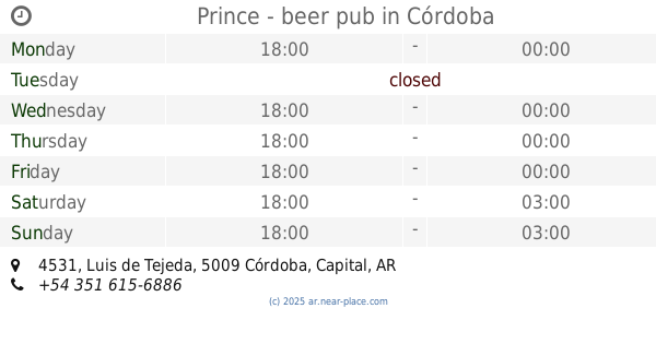
Prince - beer pub
Luis de Tejeda 4531, Córdoba
Bar
read more
204 m
Bowling Stroker
Avenida Rafael Núñez 4615, Córdoba
Bar
read more
368 m
Panicafe
X5009LDF, Gregorio Y. Gavier 2084, Córdoba
Bar
read more
452 m
Caceratto
X5009CFX, Avenida Rafael Núñez 4315, Córdoba
Bar
read more
497 m
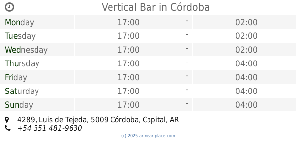
Vertical Bar
Luis de Tejeda 4289, Córdoba
Bar
read more
594 m
A
Juan de Avila y Zárate, Córdoba
Bar
read more
601 m
Maracuyá bar
Juan de Avila y Zárate 2138, Córdoba
Bar
read more
605 m
Johnny B.Good
Avenida Rafael Nuñez 4791, Córdoba
Bar
read more
624 m
Antares Cerro
Av. Rafael Núñez 4226, Córdoba
Bar
read more
645 m
Bendito
Avenida Rafael Núñez 4227, cordoba capital
Bar
read more
664 m
Cuatro Catorce Tejeda
Luis de Tejeda 4201, Córdoba
Bar
read more
672 m
Lugar Secreto
José Roque Funes 1706-1798, X5009LFT
Bar
read more
737 m
Rock your Beer
4155, Luis de Tejeda, Córdoba
Bar
read more
848 m
Cassaro Chop Cerro
Avenida Padre Antonio María Claret 4124, Córdoba
Bar
read more
858 m
Antares Córdoba Cerro de las Rosas
Avenida Rafael Núñez 4226, Córdoba
Bar
read more
893 m
La Esquina De Tejeda
Luis de Tejeda 4050 5000, Córdoba
Bar
read more
898 m
Charly Bar
Cordoba
Bar
read more
942 m
Nuñez Restó
5009, Avenida Rafael Núñez 3960, Córdoba
Bar
read more
947 m
Shanti
Av. Rafael Núñez 4005, Córdoba
Bar
read more
970 m
El Pungo Urbano
5100,, Avenida Rafael Núñez 5002, Córdoba
Bar
read more
997 m
Francisca
Juan Planas 2200-2298, X5009JID
Bar
read more
1.067 km
Jaguary Mink S.A.
Avenida Recta Martinolli 5197, Córdoba
Bar
read more
1.074 km
Baxter Lounge
Luis de Tejeda 3961, Córdoba
Bar
read more
1.135 km
Pamplona
Juan Carlos Castagnino 2188, Tablada Park, Córdoba
Bar
read more
1.209 km
Barracuda
Av. Rafael Núñez 3913, Cerro de las Rosas, Córdoba
Bar
read more
📑
all categories
Accounting
Administrative area level 1
Administrative area level 2
Airport
Amusement park
Aquarium
Art gallery
Atm
Bakery
Bank
Bar
Beauty salon
Bicycle store
Book store
Bowling alley
Bus station
Cafe
Campground
Car dealer
Car rental
Car repair
Car wash
Casino
Cemetery
Church
City hall
Clothing store
Colloquial area
Convenience store
Country
Courthouse
Dentist
Department store
Doctor
Electrician
Electronics store
Embassy
Establishment
Finance
Fire station
Florist
Food
Funeral home
Furniture store
Gas station
General contractor
Grocery or supermarket
Gym
Hair care
Hardware store
Health
Hindu Temple
Home goods store
Hospital
Insurance agency
Intersection
Jewelry store
Laundry
Lawyer
Library
Light rail station
Liquor store
Local government office
Locality
Locksmith
Lodging
Meal delivery
Meal takeaway
Mosque
Movie rental
Movie theater
Moving company
Museum
Natural feature
Neighborhood
Night club
Painter
Park
Parking
Pet store
Pharmacy
Physiotherapist
Place of worship
Plumber
Point of interest
Police
Political
Post office
Premise
Real estate agency
Restaurant
Roofing contractor
Route
Rv park, camping
School
Shoe store
Shopping mall
Spa
Stadium
Storage
Store
Subpremise
Subway station
Supermarket
Synagogue
Taxi stand
Train station
Transit station
Travel agency
University
Veterinary care
Zoo
sublocality level 1
sublocality level 3
↑