Bar nearby Pizzería UNION
Argentina
Bar nearby Pizzería UNION
Pizzería UNION
1509, Zañartu, C1424, Comuna 7, Buenos Aires, AR Argentina
contacts phone
:
+54 49213172
Latitude:
-34.6405623
, Longitude:
-58.4388591
larger map & directions
read more
nearest Bar
167 m
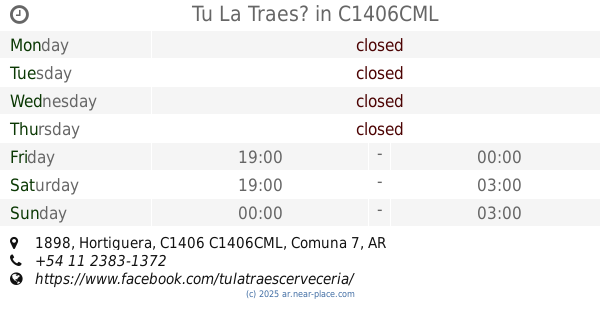
Tu La Traes?
Hortiguera 1898, C1406CML
Bar
read more
299 m
Kalamora
Crespo 2011
Bar
read more
417 m
Balbastro
Balbastro
Bar
read more
444 m
Dandy Dam de Ines Maldonado y David Morgan S H
Emilio Mitre 1455
Bar
read more
479 m
Alejandro
Picheuta 1671
Bar
read more
522 m
Salteñas El Conejo
Corea 1768
Bar
read more
690 m
Moly's
La Capital
Bar
read more
719 m
Camden Resto Bar
(1424), Salas 850
Bar
read more
719 m
Camden
(1424), Salas 850
Bar
read more
731 m
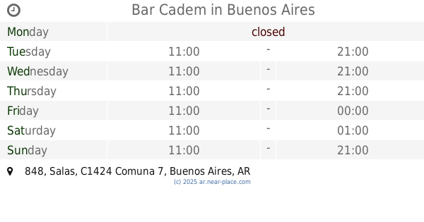
Bar Cadem
Salas 848
Bar
read more
780 m
Vinoteca Sabores
Avenida Asamblea 653
Bar
read more
905 m
LA CASONA de Bajo Flores
Calle 1
Bar
read more
933 m
S*LAY Resto-pub Cervezaria
Avenida José María Moreno 1293, C1424AAM
Bar
read more
933 m
Tomapavó Resto Bar
Avenida José María Moreno 1293
Bar
read more
979 m
El Patio
Emilio Mitre 956
Bar
read more
1.025 km
Kiosco La Alegria
y, Viel
Bar
read more
1.033 km
Kiosco La Alegria
Viel 1822
Bar
read more
1.104 km
Snak Bar La Peruana
C1437BSG, Avenida Perito Moreno 1917
Bar
read more
1.249 km
Bar Al Paso Marcelito
Avenida General Francisco Fernández de la Cruz
Bar
read more
1.325 km
Cerveza Hormiga Negra Caballito
843, CII, Avenida Directorio
Bar
read more
1.516 km
Anoeta Bar
José Bonifacio 641
Bar
read more
1.757 km
Capriccio
Avenida Pedro Goyena 358
Bar
read more
2.11 km
xoxo fiestas
José Mármol 968
Bar
read more
2.206 km
La casa del Diegui :)
Avenida San Juan 4028, C1233ABX
Bar
read more
2.243 km
Exesso Bar
Acceso A Avenida Boedo
Bar
read more
📑
all categories
Accounting
Administrative area level 1
Administrative area level 2
Airport
Amusement park
Aquarium
Art gallery
Atm
Bakery
Bank
Bar
Beauty salon
Bicycle store
Book store
Bowling alley
Bus station
Cafe
Campground
Car dealer
Car rental
Car repair
Car wash
Casino
Cemetery
Church
City hall
Clothing store
Colloquial area
Convenience store
Country
Courthouse
Dentist
Department store
Doctor
Electrician
Electronics store
Embassy
Establishment
Finance
Fire station
Florist
Food
Funeral home
Furniture store
Gas station
General contractor
Grocery or supermarket
Gym
Hair care
Hardware store
Health
Hindu Temple
Home goods store
Hospital
Insurance agency
Intersection
Jewelry store
Laundry
Lawyer
Library
Light rail station
Liquor store
Local government office
Locality
Locksmith
Lodging
Meal delivery
Meal takeaway
Mosque
Movie rental
Movie theater
Moving company
Museum
Natural feature
Neighborhood
Night club
Painter
Park
Parking
Pet store
Pharmacy
Physiotherapist
Place of worship
Plumber
Point of interest
Police
Political
Post office
Premise
Real estate agency
Restaurant
Roofing contractor
Route
Rv park, camping
School
Shoe store
Shopping mall
Spa
Stadium
Storage
Store
Subpremise
Subway station
Supermarket
Synagogue
Taxi stand
Train station
Transit station
Travel agency
University
Veterinary care
Zoo
sublocality level 1
sublocality level 3
↑