Bar nearby Velvet Bar
Argentina
Bar nearby Velvet Bar
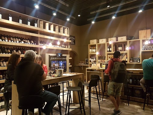
Velvet Bar
513, Avenida Directorio, C1424, Comuna 6, Buenos Aires, AR Argentina
contacts phone
:
+54
Latitude:
-34.6279685
, Longitude:
-58.4342338
larger map & directions
read more
nearest Bar
190 m
Taffer
391, CID C1424CID C1424 CABA AR, Avenida Directorio, Buenos Aires
Bar
read more
230 m
Cervecería 11.25
Bar
read more
237 m
Anoeta Bar
José Bonifacio 641
Bar
read more
247 m
dBox
C1424BSF, Avenida Pedro Goyena 515
Bar
read more
252 m
Brauhausbvier
Beauchef 701-799, C1424BDO
Bar
read more
311 m
Capriccio
Avenida Pedro Goyena 358
Bar
read more
407 m
Growlers Caballito - Comunidad Cervecera
Doblas 857
Bar
read more
450 m
Cerveza Hormiga Negra Caballito
843, CII, Avenida Directorio
Bar
read more
477 m
Escala doblas
Doblas 1026
Bar
read more
579 m
Barrel Vinos - Wine Bar
Avenida Pedro Goyena 102
Bar
read more
590 m
Maximus
Senillosa 722
Bar
read more
598 m
Josefina
Viel 524
Bar
read more
651 m
Tomapavó Resto Bar
Avenida José María Moreno 1293
Bar
read more
702 m
Vinoteca Sabores
Avenida Asamblea 653
Bar
read more
795 m
Antares Callito
Avenida Pedro Goyena 1100-1054, Buenos Aires
Bar
read more
804 m
La Birra Bar
Carlos Calvo 4317
Bar
read more
834 m
Vittorio Resto Bar
Avenida del Barco Centenera 295
Bar
read more
864 m
La Cuisineria RestoBar
Viel 314
Bar
read more
888 m
Catarsis Vinoteca
Carlos Calvo 4242
Bar
read more
904 m
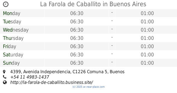
La Farola de Caballito
Avenida Independencia 4399
Bar
read more
944 m
xoxo fiestas
José Mármol 968
Bar
read more
1.023 km
Rusticana
Avenida Juan Bautista Alberdi 1099
Bar
read more
1.039 km
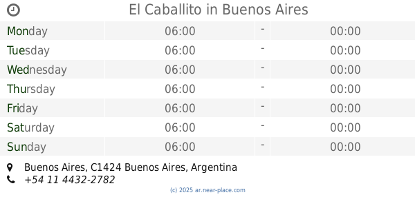
El Caballito
Bar
read more
1.083 km
Bánova, Heladería y Cafetería
Av. Juan Bautista Alberdi 1202
Bar
read more
1.116 km
TRES80 Restó Lounge Terraza
Avenida La Plata 376
Bar
read more
📑
all categories
Accounting
Administrative area level 1
Administrative area level 2
Airport
Amusement park
Aquarium
Art gallery
Atm
Bakery
Bank
Bar
Beauty salon
Bicycle store
Book store
Bowling alley
Bus station
Cafe
Campground
Car dealer
Car rental
Car repair
Car wash
Casino
Cemetery
Church
City hall
Clothing store
Colloquial area
Convenience store
Country
Courthouse
Dentist
Department store
Doctor
Electrician
Electronics store
Embassy
Establishment
Finance
Fire station
Florist
Food
Funeral home
Furniture store
Gas station
General contractor
Grocery or supermarket
Gym
Hair care
Hardware store
Health
Hindu Temple
Home goods store
Hospital
Insurance agency
Intersection
Jewelry store
Laundry
Lawyer
Library
Light rail station
Liquor store
Local government office
Locality
Locksmith
Lodging
Meal delivery
Meal takeaway
Mosque
Movie rental
Movie theater
Moving company
Museum
Natural feature
Neighborhood
Night club
Painter
Park
Parking
Pet store
Pharmacy
Physiotherapist
Place of worship
Plumber
Point of interest
Police
Political
Post office
Premise
Real estate agency
Restaurant
Roofing contractor
Route
Rv park, camping
School
Shoe store
Shopping mall
Spa
Stadium
Storage
Store
Subpremise
Subway station
Supermarket
Synagogue
Taxi stand
Train station
Transit station
Travel agency
University
Veterinary care
Zoo
sublocality level 1
sublocality level 3
↑