Bar nearby Z1 Panchos Crvezas
Argentina
Bar nearby Z1 Panchos Crvezas
Z1 Panchos Crvezas
1363, Avenida Brasil, C1154, Comuna 1, Buenos Aires, AR Argentina
contacts phone
:
+54
Latitude:
-34.6282089
, Longitude:
-58.3850781
larger map & directions
read more
nearest Bar
125 m
Bar Michi
Avenida Brasil 1300
Bar
read more
199 m
bar Victoria
O'Brien 1219
Bar
read more
230 m
Chupi Chupi Bar
Salta 1794
Bar
read more
250 m
Charly
Pavón 1299
Bar
read more
309 m
Estación Quilmes Bar
C1137ABA, O'Brien 1157
Bar
read more
332 m
Bar
C1151ABA, Pavón 1115
Bar
read more
447 m
La Guarda
Presidente Luis Sáenz Peña 1974
Bar
read more
613 m
La Armonia Cafe Bar
15 de Noviembre de 1889 1799
Bar
read more
678 m
Pulpería Flamingo
Combate de los Pozos 1964
Bar
read more
682 m
Drink Wine Store Argentina
Herrera 101, Buenos Aires
Bar
read more
740 m
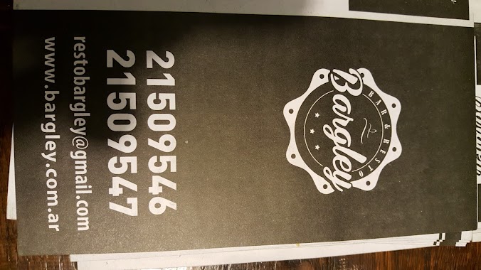
Bargley
Barracas
Bar
read more
742 m
Bar la iberica
Avenida Entre Ríos 1296, Buenos Aires
Bar
read more
905 m
Porters Cervecería
Avenida Montes de Oca 276
Bar
read more
922 m
Buen Provecho
Piedras 1280
Bar
read more
930 m
Bar San José
San José 1000, Buenos Aires
Bar
read more
937 m
Santa Lucía
Avenida San Juan 1899
Bar
read more
989 m
Rotisería Miramar
Avenida San Juan 1999
Bar
read more
1.047 km
Bravo Ana M
Pichincha 1880
Bar
read more
1.107 km
Vente Paca
20, ADB, Santa Cruz
Bar
read more
1.147 km
Cuarto Apóstol
Piedras 1040
Bar
read more
1.164 km
Acusticos En La Terraza
Piedras 1020
Bar
read more
1.178 km
D&H Restaurante chino
Piedras 1006
Bar
read more
1.216 km
La nueva esquina
Carlos Calvo 1999
Bar
read more
1.226 km
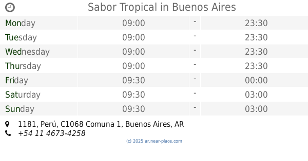
Sabor Tropical
C1068AAM, Perú 1181
Bar
read more
1.358 km
La Habanilla
San Telmo - Perú 1016, Buenos Aires, Autonomous City of Buenos Aires
Bar
read more
📑
all categories
Accounting
Administrative area level 1
Administrative area level 2
Airport
Amusement park
Aquarium
Art gallery
Atm
Bakery
Bank
Bar
Beauty salon
Bicycle store
Book store
Bowling alley
Bus station
Cafe
Campground
Car dealer
Car rental
Car repair
Car wash
Casino
Cemetery
Church
City hall
Clothing store
Colloquial area
Convenience store
Country
Courthouse
Dentist
Department store
Doctor
Electrician
Electronics store
Embassy
Establishment
Finance
Fire station
Florist
Food
Funeral home
Furniture store
Gas station
General contractor
Grocery or supermarket
Gym
Hair care
Hardware store
Health
Hindu Temple
Home goods store
Hospital
Insurance agency
Intersection
Jewelry store
Laundry
Lawyer
Library
Light rail station
Liquor store
Local government office
Locality
Locksmith
Lodging
Meal delivery
Meal takeaway
Mosque
Movie rental
Movie theater
Moving company
Museum
Natural feature
Neighborhood
Night club
Painter
Park
Parking
Pet store
Pharmacy
Physiotherapist
Place of worship
Plumber
Point of interest
Police
Political
Post office
Premise
Real estate agency
Restaurant
Roofing contractor
Route
Rv park, camping
School
Shoe store
Shopping mall
Spa
Stadium
Storage
Store
Subpremise
Subway station
Supermarket
Synagogue
Taxi stand
Train station
Transit station
Travel agency
University
Veterinary care
Zoo
sublocality level 1
sublocality level 3
↑