Cafe nearby Bonafide
Argentina
Cafe nearby Bonafide
Bonafide
1801, Avenida Raúl Scalabrini Ortíz, C1414, Comuna 14, Buenos Aires, AR Argentina
contacts phone
:
+54
website:
www.bonafide.com.ar
Latitude:
-34.5897556
, Longitude:
-58.4229254
larger map & directions
read more
nearest Cafe
190 m
Malabia e Costa Rica
C1414DMK, Malabia 1801-1821
Cafe
read more
290 m
La Panera Rosa
Costa Rica 4582
Cafe
read more
317 m
Café Bar Philadelphia
Guatemala 4602
Cafe
read more
420 m
bBlue
Armenia 1692
Cafe
read more
480 m
Cocina Oliveira
C1414DGG, Jorge Luis Borges 1975
Cafe
read more
480 m
Whoopies
C1425EZF, Charcas 4006
Cafe
read more
497 m
Cocu - Bom Café
C1414DMF, Malabia 1510
Cafe
read more
547 m
Coffe Sweet & Deli
C1425BWO, Soler 3945
Cafe
read more
550 m
TAKEAWAY
Paraguay 4477
Cafe
read more
679 m
Vía Varese
Güemes 4246
Cafe
read more
740 m
Cafeto Expresso Bar
Güemes 4299
Cafe
read more
794 m
Café Martínez
Bulnes 1790
Cafe
read more
807 m
Tipo Siete
C1414BEC, Avenida Coronel Niceto Vega 4769
Cafe
read more
813 m
Café HAUS
Avenida Santa Fe 3618
Cafe
read more
842 m
Café Güemes
Francisco Acuña de Figueroa 1220
Cafe
read more
857 m
Nucha
Vidt 2000, Buenos Aires
Cafe
read more
872 m
Heladeria Y Cafetería Palermo
Julián Álvarez 2492
Cafe
read more
894 m
Coffe
Soler 3602, C1425BWI
Cafe
read more
1.099 km
La Tolva
Avenida Córdoba 3499
Cafe
read more
1.112 km
Sugar & Spice
Guatemala 5415, Buenos Aires
Cafe
read more
1.212 km
Cirse La Fábrica
Avenida Córdoba 3400
Cafe
read more
1.218 km
Hugo's Cafe
Castillo 388
Cafe
read more
1.22 km
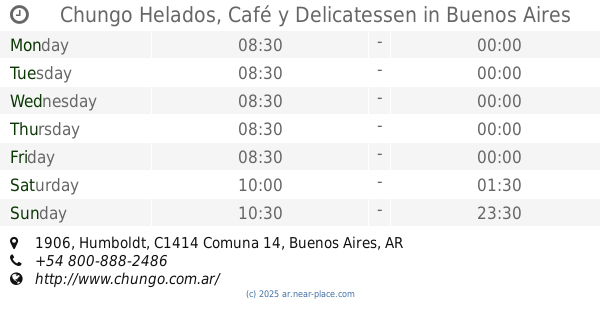
Chungo Helados, Café y Delicatessen
Humboldt 1906
Cafe
read more
1.273 km
Via Vecchia
Avenida General Las Heras 3800
Cafe
read more
1.307 km
Begoñia
Fitz Roy 1987
Cafe
read more
📑
all categories
Accounting
Administrative area level 1
Administrative area level 2
Airport
Amusement park
Aquarium
Art gallery
Atm
Bakery
Bank
Bar
Beauty salon
Bicycle store
Book store
Bowling alley
Bus station
Cafe
Campground
Car dealer
Car rental
Car repair
Car wash
Casino
Cemetery
Church
City hall
Clothing store
Colloquial area
Convenience store
Country
Courthouse
Dentist
Department store
Doctor
Electrician
Electronics store
Embassy
Establishment
Finance
Fire station
Florist
Food
Funeral home
Furniture store
Gas station
General contractor
Grocery or supermarket
Gym
Hair care
Hardware store
Health
Hindu Temple
Home goods store
Hospital
Insurance agency
Intersection
Jewelry store
Laundry
Lawyer
Library
Light rail station
Liquor store
Local government office
Locality
Locksmith
Lodging
Meal delivery
Meal takeaway
Mosque
Movie rental
Movie theater
Moving company
Museum
Natural feature
Neighborhood
Night club
Painter
Park
Parking
Pet store
Pharmacy
Physiotherapist
Place of worship
Plumber
Point of interest
Police
Political
Post office
Premise
Real estate agency
Restaurant
Roofing contractor
Route
Rv park, camping
School
Shoe store
Shopping mall
Spa
Stadium
Storage
Store
Subpremise
Subway station
Supermarket
Synagogue
Taxi stand
Train station
Transit station
Travel agency
University
Veterinary care
Zoo
sublocality level 1
sublocality level 3
↑