Cafe nearby Jacinta Café
Argentina
Cafe nearby Jacinta Café
Jacinta Café
Superi 1401, 1426 CABA, Argentina
contacts phone
:
+54
Latitude:
-34.5742859
, Longitude:
-58.459479
larger map & directions
read more
nearest Cafe
69 m
McCafé
Avenida Elcano 3240, C1426EJQ
Cafe
read more
241 m
Crisol
Capitán General Ramón Freire 1502, AWF
Cafe
read more
317 m
El Inicio
Avenida Forest 1399
Cafe
read more
353 m
Los Norteños
Avenida Forest 1296
Cafe
read more
376 m
Freddo
Avenida Elcano 3019
Cafe
read more
382 m
Confitería Y Panadería La Argentina
C1427DNA, Avenida de los Incas 3551-3599
Cafe
read more
389 m
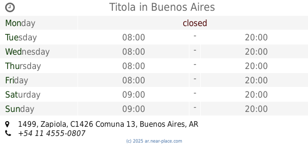
Titola
Zapiola 1499
Cafe
read more
655 m
Al Grano Espresso Bar
Virrey Avilés 3895
Cafe
read more
749 m
La Dulce Esquina
Moldes 1502
Cafe
read more
808 m
La Aurora Panadería Cafetería
Avenida de los Incas 3910
Cafe
read more
823 m
Maru Botana - Next Door
C1428DTB, Echeverría 3240
Cafe
read more
886 m
Café Bar Oriente
Avenida Álvarez Thomas 1800
Cafe
read more
892 m
VIA VARESE
Moldes 1800
Cafe
read more
932 m
Balcarce
C1427CCH, Avenida Álvarez Thomas 703
Cafe
read more
970 m
Chungo
Virrey del Pino 2500
Cafe
read more
979 m
Luna del Sur
Virrey Arredondo 2497
Cafe
read more
979 m
Café Martínez
Juramento 3102
Cafe
read more
997 m
La Panotteca
Zapiola 2125
Cafe
read more
1.029 km
RUSTIC the pastry shop
C1428CXF, CXF, Zapiola 2125, Buenos Aires
Cafe
read more
1.032 km
De La Cuadra Bar
Avenida Federico Lacroze 3074
Cafe
read more
1.062 km
MacJac's
Ciudad de La Paz 1111
Cafe
read more
1.12 km
Furchi Artesanal
Avenida Cabildo 1508
Cafe
read more
1.126 km
BellAria
Charlone 602
Cafe
read more
1.127 km
Café Van Gogh
Avenida Cabildo 1500, CABA
Cafe
read more
1.16 km
Priana
Avenida Federico Lacroze 3795
Cafe
read more
📑
all categories
Accounting
Administrative area level 1
Administrative area level 2
Airport
Amusement park
Aquarium
Art gallery
Atm
Bakery
Bank
Bar
Beauty salon
Bicycle store
Book store
Bowling alley
Bus station
Cafe
Campground
Car dealer
Car rental
Car repair
Car wash
Casino
Cemetery
Church
City hall
Clothing store
Colloquial area
Convenience store
Country
Courthouse
Dentist
Department store
Doctor
Electrician
Electronics store
Embassy
Establishment
Finance
Fire station
Florist
Food
Funeral home
Furniture store
Gas station
General contractor
Grocery or supermarket
Gym
Hair care
Hardware store
Health
Hindu Temple
Home goods store
Hospital
Insurance agency
Intersection
Jewelry store
Laundry
Lawyer
Library
Light rail station
Liquor store
Local government office
Locality
Locksmith
Lodging
Meal delivery
Meal takeaway
Mosque
Movie rental
Movie theater
Moving company
Museum
Natural feature
Neighborhood
Night club
Painter
Park
Parking
Pet store
Pharmacy
Physiotherapist
Place of worship
Plumber
Point of interest
Police
Political
Post office
Premise
Real estate agency
Restaurant
Roofing contractor
Route
Rv park, camping
School
Shoe store
Shopping mall
Spa
Stadium
Storage
Store
Subpremise
Subway station
Supermarket
Synagogue
Taxi stand
Train station
Transit station
Travel agency
University
Veterinary care
Zoo
sublocality level 1
sublocality level 3
↑