Cafe nearby Jaramillo Cafe
Argentina
Cafe nearby Jaramillo Cafe
Jaramillo Cafe
3700, 11 de Septiembre de 1888, C1429, Buenos Aires, Comuna 13, AR Argentina
contacts phone
:
+54
website:
instagram.com
Latitude:
-34.5448728
, Longitude:
-58.4621569
larger map & directions
read more
nearest Cafe
114 m
Chik - Café
Avenida Crisólogo Larralde 1698
Cafe
read more
173 m
White Coffee
Crisólogo Larralde 1590, C1429BSS
Cafe
Store
Food
Point of interest
Establishment
read more
268 m
PRAX LUCAS
C1429BIW, 11 de Septiembre 3999
Cafe
read more
591 m
Hipólito Living Café
11 de Septiembre 3102
Cafe
read more
670 m
Cafe Leon
Ramallo 1736
Cafe
read more
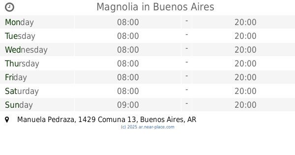
704 m
Magnolia
2288, Manuela Pedraza
Cafe
read more
748 m
Regalería Kevin
Avenida Cabildo 3896
Cafe
read more
773 m
El Puntal
Ramallo 2104
Cafe
read more
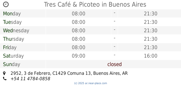
797 m
Tres Café & Picoteo
C1429BFD, 3 de Febrero 2952
Cafe
read more
806 m
Starbucks
C1429BZJ, Juana Azurduy 2406
Cafe
read more
806 m
Starbucks
Juana Azurduy 2406, CABA
Cafe
read more
871 m
Hay Café Café
Quesada 1515
Cafe
read more
872 m
Starbucks
Avenida Cabildo 4300
Cafe
read more
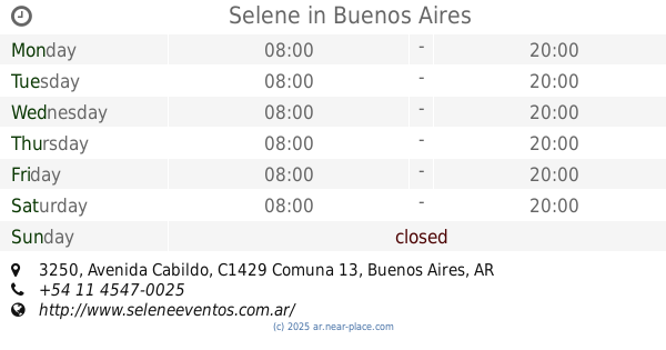
908 m
Selene
Avenida Cabildo 3250
Cafe
read more
921 m
Macarella
11 de Septiembre 4642, C1429BJL
Cafe
read more
940 m
la isla del sol
Quesada 2159, C1429COC
Cafe
read more
944 m
Goiabada
3 de Febrero 2823
Cafe
read more
947 m
Diaz De La Rossi Maniera
Núñez 2591
Cafe
read more
947 m
La Rossi Maniera
Núñez 2591
Cafe
read more
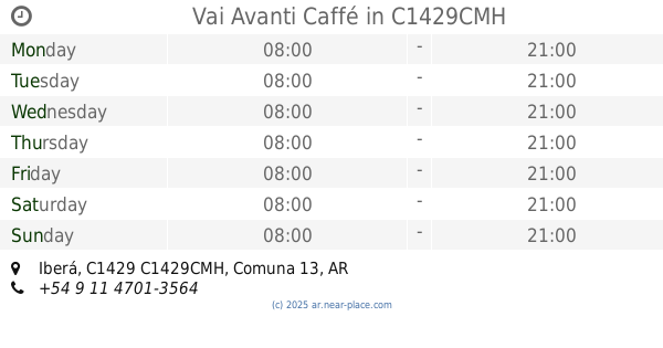
965 m
Vai Avanti Caffé
2386, Iberá, C1429CMH
Cafe
read more
995 m
New Coffee
Avenida Cabildo 3102
Cafe
read more
1.019 km
Crisol Núñez
1602, Avenida Congreso
Cafe
read more
1.03 km
Moshu
Moldes 3802
Cafe
read more
1.047 km
Almacén de Pizzas
Avenida del Libertador 6700
Cafe
read more
1.223 km
Chungo Helados, Café y Delicatessen
buenos Aires Esquina, Franklin D. Roosevelt
Cafe
read more
📑
all categories
Accounting
Administrative area level 1
Administrative area level 2
Airport
Amusement park
Aquarium
Art gallery
Atm
Bakery
Bank
Bar
Beauty salon
Bicycle store
Book store
Bowling alley
Bus station
Cafe
Campground
Car dealer
Car rental
Car repair
Car wash
Casino
Cemetery
Church
City hall
Clothing store
Colloquial area
Convenience store
Country
Courthouse
Dentist
Department store
Doctor
Electrician
Electronics store
Embassy
Establishment
Finance
Fire station
Florist
Food
Funeral home
Furniture store
Gas station
General contractor
Grocery or supermarket
Gym
Hair care
Hardware store
Health
Hindu Temple
Home goods store
Hospital
Insurance agency
Intersection
Jewelry store
Laundry
Lawyer
Library
Light rail station
Liquor store
Local government office
Locality
Locksmith
Lodging
Meal delivery
Meal takeaway
Mosque
Movie rental
Movie theater
Moving company
Museum
Natural feature
Neighborhood
Night club
Painter
Park
Parking
Pet store
Pharmacy
Physiotherapist
Place of worship
Plumber
Point of interest
Police
Political
Post office
Premise
Real estate agency
Restaurant
Roofing contractor
Route
Rv park, camping
School
Shoe store
Shopping mall
Spa
Stadium
Storage
Store
Subpremise
Subway station
Supermarket
Synagogue
Taxi stand
Train station
Transit station
Travel agency
University
Veterinary care
Zoo
sublocality level 1
sublocality level 3
↑