Cafe nearby Le Blé
Argentina
Cafe nearby Le Blé
Le Blé
4501, Avenida del Libertador, C1426, C1426BWG, Comuna 14, AR Argentina
contacts phone
:
+54 11 4773-1789
website:
www.leble.com.ar
Latitude:
-34.5667728
, Longitude:
-58.431458
larger map & directions
read more
nearest Cafe
131 m
FIII Fun House
Migueletes 681
Cafe
read more
228 m
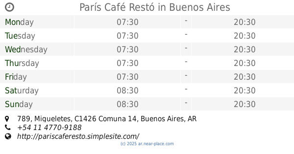
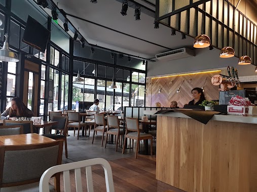
París Café Restó
Migueletes 789
Cafe
read more
233 m
Niacafe y Delicias Sa
Teniente Benjamín Matienzo 1698
Cafe
read more
241 m
Decata
Soldado de la Independencia 670
Cafe
read more
287 m
Cafe de la Imprenta
Argentina
Cafe
read more
317 m
Tilo Cafe Y Restaurant
Soldado de la Independencia 790, C1426BTV
Cafe
read more
318 m
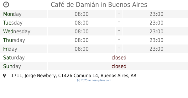
Café de Damián
Jorge Newbery 1711
Cafe
read more
418 m
Bedford Station
Arce 802
Cafe
read more
437 m
Bonafide
Jorge Newbery 1829
Cafe
read more
472 m
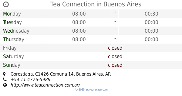
Tea Connection
1610, CTD, Gorostiaga
Cafe
read more
477 m
Confiteria Rosa
Gorostiaga 1650
Cafe
read more
484 m
Domenico Coffee & Brunch
Arce 901, Loc. 201
Cafe
read more
492 m
Starbucks
Maure 1818
Cafe
read more
552 m
cuantos Minutos De Aceso Oeste
Avenida Luis María Campos
Cafe
read more
552 m
Cafe Boccazzi
El Solar, Arce 446
Cafe
read more
554 m
Pei Chen
C1426CUH, Maure 1886, Buenos Aires
Cafe
read more
593 m
Mc Café
C1426BOH, Avenida Luis María Campos 931-999
Cafe
read more
727 m
PIT DELI
Soldado de la Independencia 1154
Cafe
read more
950 m
La Fusta
Avenida Cabildo 101
Cafe
read more
962 m
Café del Golf
Avenida Ernesto Tornquist
Cafe
read more
978 m
Maru Botana
11 de Septiembre 982
Cafe
read more
995 m
DELIBAR
Avenida Federico Lacroze 2120, 1426
Cafe
read more
1.163 km
Gourmet Service SRL
Cafe
read more
1.254 km
Repostería Candela
Ciudad de La Paz 353
Cafe
read more
1.26 km
Dia
Juan Francisco Seguí 4501-4579
Cafe
read more
📑
all categories
Accounting
Administrative area level 1
Administrative area level 2
Airport
Amusement park
Aquarium
Art gallery
Atm
Bakery
Bank
Bar
Beauty salon
Bicycle store
Book store
Bowling alley
Bus station
Cafe
Campground
Car dealer
Car rental
Car repair
Car wash
Casino
Cemetery
Church
City hall
Clothing store
Colloquial area
Convenience store
Country
Courthouse
Dentist
Department store
Doctor
Electrician
Electronics store
Embassy
Establishment
Finance
Fire station
Florist
Food
Funeral home
Furniture store
Gas station
General contractor
Grocery or supermarket
Gym
Hair care
Hardware store
Health
Hindu Temple
Home goods store
Hospital
Insurance agency
Intersection
Jewelry store
Laundry
Lawyer
Library
Light rail station
Liquor store
Local government office
Locality
Locksmith
Lodging
Meal delivery
Meal takeaway
Mosque
Movie rental
Movie theater
Moving company
Museum
Natural feature
Neighborhood
Night club
Painter
Park
Parking
Pet store
Pharmacy
Physiotherapist
Place of worship
Plumber
Point of interest
Police
Political
Post office
Premise
Real estate agency
Restaurant
Roofing contractor
Route
Rv park, camping
School
Shoe store
Shopping mall
Spa
Stadium
Storage
Store
Subpremise
Subway station
Supermarket
Synagogue
Taxi stand
Train station
Transit station
Travel agency
University
Veterinary care
Zoo
sublocality level 1
sublocality level 3
↑